Gough County

Gough County
Gough
New South Wales
Gough NSW.PNG
Location in New South Wales
Lands administrative divisions around Gough
Arrawatta Clive Clive
Arrawatta Gough Gresham
Murchison Hardinge Clarke

Gough County is one of the 141 Cadastral divisions of New South Wales.

Gough County was named in honour of Field Marshal Sir Hugh Gough, first Viscount Gough (1779-1869).[1]

Parishes

A full list of parishes found within this county; their current LGA and mapping coordinates to the approximate centre of each location is as follows:

Parish LGA Coordinates
Anderson Inverell Shire 29°48′54″S 151°18′04″E / 29.815°S 151.30111°E / -29.815; 151.30111 (Anderson Parish)
Arvid Glen Innes Severn Council 29°21′54″S 151°29′04″E / 29.365°S 151.48444°E / -29.365; 151.48444 (Arvid Parish)
Auburn Vale Inverell Shire 29°44′54″S 151°01′34″E / 29.74833°S 151.02611°E / -29.74833; 151.02611 (Auburn Vale Parish)
Balaclava Inverell Shire 29°47′54″S 151°31′04″E / 29.79833°S 151.51778°E / -29.79833; 151.51778 (Balaclava Parish)
Bald Nob Glen Innes Severn Council 29°40′54″S 151°58′04″E / 29.68167°S 151.96778°E / -29.68167; 151.96778 (Bald Nob Parish)
Beardy Plains Glen Innes Severn Council 29°42′54″S 151°49′04″E / 29.715°S 151.81778°E / -29.715; 151.81778 (Beardy Plains Parish)
Ben Lomond Guyra Shire 29°59′54″S 151°41′04″E / 29.99833°S 151.68444°E / -29.99833; 151.68444 (Ben Lomond Parish)
Blair Hill Glen Innes Severn Council 29°50′54″S 151°52′04″E / 29.84833°S 151.86778°E / -29.84833; 151.86778 (Blair Hill Parish)
Boyd Glen Innes Severn Council 29°36′54″S 151°49′04″E / 29.615°S 151.81778°E / -29.615; 151.81778 (Boyd Parish)
Bundar Glen Innes Severn Council 29°22′54″S 151°37′04″E / 29.38167°S 151.61778°E / -29.38167; 151.61778 (Bundar Parish)
Campbell Inverell Shire 29°41′54″S 151°12′04″E / 29.69833°S 151.20111°E / -29.69833; 151.20111 (Campbell Parish)
Clifton Glen Innes Severn Council 29°48′54″S 151°40′04″E / 29.815°S 151.66778°E / -29.815; 151.66778 (Clifton Parish)
Clive Inverell Shire 29°50′54″S 151°08′04″E / 29.84833°S 151.13444°E / -29.84833; 151.13444 (Clive Parish)
Deepwater Glen Innes Severn Council 29°29′54″S 151°52′04″E / 29.49833°S 151.86778°E / -29.49833; 151.86778 (Deepwater Parish)
Diehard Glen Innes Severn Council 29°40′54″S 152°03′04″E / 29.68167°S 152.05111°E / -29.68167; 152.05111 (Diehard Parish)
Ditmas Glen Innes Severn Council 29°41′54″S 151°39′04″E / 29.69833°S 151.65111°E / -29.69833; 151.65111 (Ditmas Parish)
Dumaresq Tenterfield Shire 29°11′54″S 151°24′04″E / 29.19833°S 151.40111°E / -29.19833; 151.40111 (Dumaresq Parish)
Eden Inverell Shire 29°51′54″S 151°21′04″E / 29.865°S 151.35111°E / -29.865; 151.35111 (Eden Parish)
Elsmore Inverell Shire 29°48′54″S 151°12′04″E / 29.815°S 151.20111°E / -29.815; 151.20111 (Elsmore Parish)
Fladbury Glen Innes Severn Council 29°31′54″S 151°38′04″E / 29.53167°S 151.63444°E / -29.53167; 151.63444 (Fladbury Parish)
Flagstone Tenterfield Shire 29°13′54″S 151°33′04″E / 29.23167°S 151.55111°E / -29.23167; 151.55111 (Flagstone Parish)
Fletcher Glen Innes Severn Council 29°51′54″S 151°42′04″E / 29.865°S 151.70111°E / -29.865; 151.70111 (Fletcher Parish)
Glen Innes Glen Innes Severn Council 29°43′54″S 151°46′04″E / 29.73167°S 151.76778°E / -29.73167; 151.76778 (Glen Innes Parish)
Gordon Glen Innes Severn Council 29°33′54″S 151°32′04″E / 29.565°S 151.53444°E / -29.565; 151.53444 (Gordon Parish)
Hamilton Glen Innes Severn Council 29°25′54″S 151°33′04″E / 29.43167°S 151.55111°E / -29.43167; 151.55111 (Hamilton Parish)
Herbert Inverell Shire 29°50′54″S 151°14′04″E / 29.84833°S 151.23444°E / -29.84833; 151.23444 (Herbert Parish)
Highland Home Tenterfield Shire 29°18′54″S 151°41′04″E / 29.315°S 151.68444°E / -29.315; 151.68444 (Highland Home Parish)
Kingsgate Glen Innes Severn Council 29°45′54″S 151°58′04″E / 29.765°S 151.96778°E / -29.765; 151.96778 (Kingsgate Parish)
Lands End Glen Innes Severn Council 29°16′54″S 151°29′04″E / 29.28167°S 151.48444°E / -29.28167; 151.48444 (Lands End Parish)
Llangothlin Glen Innes Severn Council 29°59′54″S 151°41′04″E / 29.99833°S 151.68444°E / -29.99833; 151.68444 (Llangothlin Parish)
Louis Glen Innes Severn Council 29°34′54″S 151°46′04″E / 29.58167°S 151.76778°E / -29.58167; 151.76778 (Louis Parish)
Macintyre Inverell Shire 29°56′54″S 151°35′04″E / 29.94833°S 151.58444°E / -29.94833; 151.58444 (Macintyre Parish)
Mann Glen Innes Severn Council 29°42′54″S 152°06′04″E / 29.715°S 152.10111°E / -29.715; 152.10111 (Mann Parish)
Marowan Glen Innes Severn Council 29°51′54″S 151°48′04″E / 29.865°S 151.80111°E / -29.865; 151.80111 (Marowan Parish)
Mitchell Glen Innes Severn Council 29°41′54″S 151°55′04″E / 29.69833°S 151.91778°E / -29.69833; 151.91778 (Mitchell Parish)
Mount Mitchell Glen Innes Severn Council 29°59′54″S 151°48′04″E / 29.99833°S 151.80111°E / -29.99833; 151.80111 (Mount Mitchell Parish)
Muir Tenterfield Shire 29°15′54″S 151°27′04″E / 29.265°S 151.45111°E / -29.265; 151.45111 (Muir Parish)
Newstead Inverell Shire 29°49′54″S 151°23′04″E / 29.83167°S 151.38444°E / -29.83167; 151.38444 (Newstead Parish)
Paradise Inverell Shire 29°54′54″S 151°31′04″E / 29.915°S 151.51778°E / -29.915; 151.51778 (Paradise Parish)
Paradise North Glen Innes Severn Council 29°18′54″S 151°34′59″E / 29.315°S 151.58306°E / -29.315; 151.58306 (Paradise North Parish)
Parkes Glen Innes Severn Council 29°27′54″S 151°58′04″E / 29.465°S 151.96778°E / -29.465; 151.96778 (Parkes Parish)
Rangers Valley Glen Innes Severn Council 29°32′54″S 151°47′04″E / 29.54833°S 151.78444°E / -29.54833; 151.78444 (Rangers Valley Parish)
Robertson Glen Innes Severn Council 29°40′54″S 152°09′04″E / 29.68167°S 152.15111°E / -29.68167; 152.15111 (Robertson Parish)
Ross Inverell Shire 29°43′54″S 151°27′04″E / 29.73167°S 151.45111°E / -29.73167; 151.45111 (Ross Parish)
Rusden Glen Innes Severn Council 29°43′54″S 151°53′04″E / 29.73167°S 151.88444°E / -29.73167; 151.88444 (Rusden Parish)
Scone Glen Innes Severn Council 29°29′54″S 151°36′04″E / 29.49833°S 151.60111°E / -29.49833; 151.60111 (Scone Parish)
Scott Glen Innes Severn Council 29°31′54″S 152°01′04″E / 29.53167°S 152.01778°E / -29.53167; 152.01778 (Scott Parish)
Severn Glen Innes Severn Council 29°33′54″S 151°51′04″E / 29.565°S 151.85111°E / -29.565; 151.85111 (Severn Parish)
Stonehenge Glen Innes Severn Council 29°48′54″S 151°43′04″E / 29.815°S 151.71778°E / -29.815; 151.71778 (Stonehenge Parish)
Strachan Glen Innes Severn Council 29°22′54″S 151°42′04″E / 29.38167°S 151.70111°E / -29.38167; 151.70111 (Strachan Parish)
Strathbogie Glen Innes Severn Council 29°29′54″S 151°31′04″E / 29.49833°S 151.51778°E / -29.49833; 151.51778 (Strathbogie Parish)
Strathbogie North Glen Innes Severn Council 29°23′54″S 151°34′04″E / 29.39833°S 151.56778°E / -29.39833; 151.56778 (Strathbogie North Parish)
Swanbrook Inverell Shire 29°42′54″S 151°17′04″E / 29.715°S 151.28444°E / -29.715; 151.28444 (Swanbrook Parish)
Swanvale Inverell Shire 29°43′54″S 151°22′04″E / 29.73167°S 151.36778°E / -29.73167; 151.36778 (Swanvale Parish)
Tent Hill Glen Innes Severn Council 29°25′46″S 151°40′08″E / 29.42944°S 151.66889°E / -29.42944; 151.66889 (Tent Hill Parish)
The Brothers Glen Innes Severn Council 29°46′54″S 152°05′04″E / 29.78167°S 152.08444°E / -29.78167; 152.08444 (The Brothers Parish)
Waterloo Glen Innes Severn Council 29°43′54″S 151°35′04″E / 29.73167°S 151.58444°E / -29.73167; 151.58444 (Waterloo Parish)
Wellingrove Glen Innes Severn Council 29°36′54″S 151°34′04″E / 29.615°S 151.56778°E / -29.615; 151.56778 (Wellingrove Parish)
Wellington Glen Innes Severn Council 29°35′54″S 151°39′04″E / 29.59833°S 151.65111°E / -29.59833; 151.65111 (Wellington Parish)
Wellington North Tenterfield Shire 29°17′54″S 151°39′04″E / 29.29833°S 151.65111°E / -29.29833; 151.65111 (Wellington North Parish)
Wellington Vale Glen Innes Severn Council 29°23′54″S 151°46′04″E / 29.39833°S 151.76778°E / -29.39833; 151.76778 (Wellington Vale Parish)
Yarrow Glen Innes Severn Council 29°52′54″S 152°00′04″E / 29.88167°S 152.00111°E / -29.88167; 152.00111 (Yarrow Parish)
Yarrowford Glen Innes Severn Council 29°36′54″S 151°46′04″E / 29.615°S 151.76778°E / -29.615; 151.76778 (Yarrowford Parish)

References

  1. ^ Geographical Names Board of NSW

Wikimedia Foundation. 2010.

Игры ⚽ Нужна курсовая?

Look at other dictionaries:

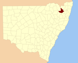
  • Gough County, New South Wales — Infobox Australian cadastral name = Gough state = New South Wales caption = Location in New South Wales near nw = Arrawatta near n = Clive near ne = Clive near e = Gresham near se = Clarke near s = Hardinge near sw = Murchison near w =… …   Wikipedia

  • Gough, Sir Hugh — ▪ British military officer also called (1846–49)  Baron Gough , or (from 1849)  1st Viscount Gough  born Nov. 3, 1779, Limerick, County Limerick, Ire. died March 2, 1869, St. Helen s, near Dublin       British soldier prominent in the Peninsular… …   Universalium

  • Electoral district of Gough — Gough was a former electoral district of the Legislative Assembly in the Australian state of New South Wales, which replaced Glen Innes and part of Gwydir in 1904 and was named after the Gough County, which includes the town of Glen Innes. In… …   Wikipedia

  • County of San Francisco — San Francisco Spitzname: Frisco, San Fran San Francisco mit Golden Gate Bridge im Vordergrund …   Deutsch Wikipedia

  • Gough — Recorded in several spellings including Gough, Goff, Goffe, Goth, Gouth, and unusual dialectals such as Coath and Couth, this interesting surname is usually English when recorded in England. It has two known origins. The first is occupational… …   Surnames reference

  • Darren Gough — Personal information Full name Darren Gough Born 18 September 1970 (1970 09 18) (age 41) Monk Bretton …   Wikipedia

  • Yorkshire County Cricket Club in 2007 — Championship= County Championship ScorecardsSurrey v YorkshireTest match date = 6 june 9 June team1 = Yorkshire team2 = Surrey score team1 inns1 = 594 9 dec (154 overs) runs team1 inns1 = Jason Gillespie 123* (192) wickets team1 inns1 = Azhar… …   Wikipedia

  • Yorkshire County Cricket Club in 2008 — Friends ProvidentFirst Class Bowling StatisticsTwenty20 Batting StatisticsTwenty20 Bowling StatisticsFixturesPre SeasonYorkshire began their preparation for the 2008 season in the United Arab Emirates, playing four games in the Pro Arch Trophy.… …   Wikipedia

  • Hugh Gough — Hugh Gough, 1. Viscount Gough Hugh Gough, 1. Viscount Gough (* 3. November 1779 in Woodstown, Limerick; † 3. März 1869 in London) war ein britischer Feldmarschall. Leben Gough trat 1794 in die Armee ein und nahm 1795 an der Eroberung des …   Deutsch Wikipedia

  • Anstruther-Gough-Calthorpe Baronets — The Anstruther Gough Calthorpe Baronetcy, of Elvetham Hall in Elvetham in the County of Southampton, is a title in the Peerage of the United Kingdom. It was created on 1 July 1929 for Fitzroy Anstruther Gough Calthorpe. Born Fitzroy Hamilton… …   Wikipedia

Share the article and excerpts

Direct link
Do a right-click on the link above
and select “Copy Link”