- Courchevel Airport
-
Courchevel Airport
Aérodrome de Courchevel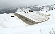
IATA: CVF – ICAO: LFLJ Summary Airport type Public Serves Courchevel Location Courchevel Elevation AMSL 6,588 ft / 2,008 m Coordinates 45°23′51″N 06°38′04″E / 45.3975°N 6.63444°ECoordinates: 45°23′51″N 06°38′04″E / 45.3975°N 6.63444°E Runways Direction Length Surface ft m 04/22 1,788 545 Asphalt Courchevel Airport is a French airport that serves Courchevel, a ski area. The airport has a very short runway of only 525 metres (1,788ft) with gradient of 18.5 %. There is no go-around procedure in this airport. De Havilland Twin Otters and Dash 7s have served the airport, but now more Cessnas and helicopters serve the airport.
The airport is considered dangerous, having a difficult approach, an upslope runway and a hill with ski runs. The airport's elevation is at 6,588 feet (2,008 m). The History Channel program Most Extreme Airports, ranks it as the 7th most dangerous airport in the world.[1] The pre-credit sequence of the James Bond film Tomorrow Never Dies was filmed at Courchevel.
References
- ^ Most Extreme Airports; channel 5; October 14, 2010
External links
Categories:- Airports in France
- Buildings and structures in Savoie
- French airport stubs

Wikimedia Foundation. 2010.