- Cratendune
-
Coordinates: 52°23′56″N 0°15′50″E / 52.399°N 0.264°E
Cratendune 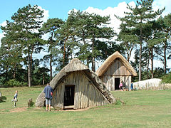
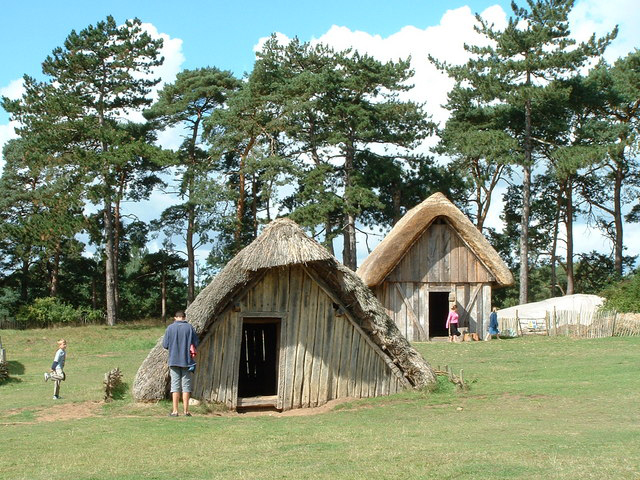
Reconstruction of an Anglo-Saxon village
in West Stow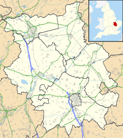
 Cratendune
Cratendune shown within CambridgeshireOS grid reference TL54138029 District East Cambridgeshire Shire county Cambridgeshire Region East Country England Sovereign state United Kingdom EU Parliament East of England List of places: UK • England • Cambridgeshire Cratendune (Medieval Latin: vallis Cracti) is the name of the lost village reported in the Liber Eliensis, the history of the abbey, then Ely Cathedral, compiled towards the end of the 12th century, as the 500th anniversary of the traditional founding date drew near.[1] As no direction is indicated in Liber Eliensis, a number of archaeological sites are therefore candidates for this lost village.
Contents
History
Reading from the Liber Eliensis MS folio 2, which is a 12th century Benedictine history of Ely written in Latin, Bentham describes Æthelberht of Kent, Chief of the Saxon Kings, founding a church at the insistence of Augustine (died 26 May 604). The church, dedicated to the Virgin Mary, was located about 1.6 kilometres (1 mi)[nb 1] from what is now Ely Cathedral at a place called Cratendune.[2] The date mentioned for this founding was the year 607,[nb 2] three years after Augustine's death. This incongruity was attributed by Bentham to a mistake by the monk transcribing this history.[3]
Fairweather, translating the same Latin text, records the site 1.6 kilometres (1 mi)[4] from the present site of the Cathedral:
In times of old , so it is said, there was a vill, that is, in Latin, vallis Cracti[nb 3] a mile away from the city which now exists. There one frequently finds implements of iron-work and the coinage of past kings, and the fact that it was for a long time a place inhabited by men is clear from various pieces of evidence. But after Æthelthryth, beloved of God, chose to dwell there, ...she sited her living-quarters near the course of the river, on higher ground[5]
Staffed by Benedictine monks, the church was abandoned, perhaps destroyed in around 650 by or on the orders of the pagan Penda of Mercia.[2][6]
No direction is indicated in Liber Eliensis; a number of archaeological sites, therefore, are candidates for this lost village. Two candidate locations are based on the survival of the toponym Cratenden. One, Cratendon Field, was identified as the lost site by the antiquarian James Bentham just south of the city of Ely[7], and the identification was repeated by James Sargant Storer, in The Antiquarian Itinerary, 1816.[8] Janet Fairweather notes that in the Ely Coucher book Cratendune Field is listed next to Grunty Fen, corroborating this identification. Cratendune also survived as a toponym associated with Chettisham in a 1251 survey.[9]
Geography
As there is no documented direction for Cratendune, the place could be anywhere. These modern places are all within 4 kilometres (2 mi) of the present day site of Ely cathedral. The cathedral is built on boulder clay resting on a Jurassic Kimmeridge Clay bed; the old course of the River Great Ouse is 2 kilometres (1 mi) south-east. The highest point in the area at 26 metres (85 ft) is 0.8 kilometres (0.5 mi) south-west towards Witchford aerodrome, now disused. At Witchford, 3 kilometres (2 mi) south-west, Fowler found an Anglo-Saxon cemetery: see below.

West Fen Road, Ely Little Downham Queen Adelaide Witchford 
 Ely Cathedral

Witchford Aerodrome[10]
(site of)Little Thetford River Great Ouse Archaeology
The search for Cratendune continues though evidence that any one site is the lost village remains sparse.[11] In 1999 there was media attention during preparation work for new buildings at West Fen Road, Ely.[12] The archaeology work subsequently undertaken indeed shows Romano-British and Anglo-Saxon occupation.[13] However, it was shown that the site was still active in the 13th century and there were no signs of an earlier Anglo-Saxon settlement here. This makes the West Fen Road site an unlikely Cratendune location.[14]
During World War II whilst constructing an aerodrome at Witchford, near Little Thetford, a cemetery was discovered.[15] Major Gordon Fowler reports witnessing a bulldozer levelling off ground and in so doing was crushing skeletons. The urgent war effort could not be stopped so little archaeological work could be undertaken. He was however able to recover some objects from the graves, which were later dated by Lethbridge to be consistent with the period AD 450–650.[16] Recent survey work has not repeated the 1943 report of an Anglo-Saxon cemetery here, instead finding Iron-Age and Roman period domestic and other remains.[17] It has been suggested that an Anglo-Saxon settlement within Ely was perhaps more spread out, being no single core settlement.[18]
See also
- History of Anglo-Saxon England
- Anglo-Saxon settlement of Britain
References
- Footnotes
- ^ Bentham (1771) p. 11 says about a mile distant from the present city
- ^ The date is given in Chronicon Abbatum et Episcoporum Eliensum, which depends in part on Liber Eliensis and shares the same source material. However, the date is not consistent with death of Augustine of Canterbury in 604
- ^ Here the translator Janet Fairweather inserts 'the down of Cractus'
- Notes
- ^ Fairweather 2005, p. 4.
- ^ a b Bentham 1771, p. 11.
- ^ Bentham 1771, pp. 11 12.
- ^ Fairweather 2005, p. 4 Note source is 1 mile; article is using British Units as per manual of style.
- ^ Fairweather 2005, book I, pp4f..
- ^ Pugh 1953, pp. 33–40.
- ^ Bentham 1771.
- ^ Storer 1816.
- ^ Fairweather 2005, p. 4 note 19.
- ^ Bomber Command:Witchford, Royal Air Force, http://www.raf.mod.uk/bombercommand/s50.html, retrieved 20 August 2010
- ^ Smith, Lisa (2007) (PDF), 25, Broad Street, Ely, Cambridgeshire Construction of Residential Dwellings, Archaeological Solutions Limited, http://ads.ahds.ac.uk/catalogue/adsdata/oasis_reports/archaeol7/ahds/dissemination/pdf/archaeol7-62442_1.pdf, retrieved 20 August 2010
- ^ "Anglo-Saxon village uncovered", BBC News, 2 November 1999, http://news.bbc.co.uk/1/hi/uk/502789.stm, retrieved 19 August 2010
- ^ (1999–2000) Cambridgeshire Historic Environment Record Late Iron Age/Conquest period settlement, West Fen Road
- ^ Regan 2001, p. 25.
- ^ (1953) Cambridgeshire Historic Environment Record Cratendune
- ^ Fowler 1948, p. 71.
- ^ CHER report 2008–9 p. 7
- ^ Stubbington, Paul (January 2008) (PDF), Ely Master Plan, Cambridgeshire Horizons, p. 3, http://www.urbed.com/cgi-bin/get_binary_doc_object.cgi?doc_id=276&fname=extra_pdf_2.pdf, retrieved 20 August 2010
- Bibliography
- Bentham, Reverend James (1771), The History and Antiquities of the Conventual and Cathedral Church of Ely: From the Foundation of the Monastery, A.D. 673. To the Year 1771, I, Cambridge University Press, http://books.google.com/books?id=y_5BAAAAYAAJ, retrieved 29 September 2010
- "Cambridgeshire Archaeology Historic Environment Team Annual Report:Lancaster Way, East Cambridgeshire" (PDF). Cambridgeshire County Council. 2008–2009. http://www.cambridgeshire.gov.uk/NR/rdonlyres/D38E6C6C-D36E-431B-84FF-FDFC5F193DD8/0/CambridgeshireArchaeologyannualreport2008_09.pdf. Retrieved 19 August 2010.
- Fairweather, Janet (2005), Liber Eliensis: a history of the Isle of Ely from the seventh century to the twelfth, The Boydell Press, ISBN 1843830159, http://books.google.com/books?id=fh5OozghywIC&
- Fowler, Gordon (1948), "Cratendune: A problem of the Dark Ages", Proceedings of the Cambridge Antiquarian Society (For the Cambridge Antiquarian Society by Bowes and Bowes) XLI: 70–73, http://books.google.com/books?id=VF5nAAAAMAAJ, retrieved 29 September 2010
- Pugh, R.B., ed. (1953), The Victoria History of the Counties of England: Cambridge and the isle of Ely, IV, Oxford University Press, http://www.british-history.ac.uk/report.aspx?compid=21908
- Regan, Roderick; Rachel Ballantyne, Mark Berger, Andrew Clerk, Chantal Conneller, Natasha Dodwell, Lorrain Higbee, Gwladys Monteil, Chris Stevens, Robert Scaife (January 2001), West Fen Road, Ely, Cambridgeshire:Cornwell Field, assessment report, 413, Cambridge Archaeological Unit, University of Cambridge
- Storer (1816), Ely, Cambridgeshire, The Antiquarian Itinerary: comprising specimens of architecture, monastic, castellated, and domestic; with other vestiges of antiquity in Great Britain
- Watson, William (1827), An historical account of the ancient town and port of Wisbech, in the Isle of Ely, in the county of Cambridge: and of the circumjacent towns and villages, the drainage of the great level of the fens, the origin of the royal franchise of the Isle of Ely &c. ..., H and J Leach, http://books.google.com/books?id=t7gLAAAAYAAJ
External links
- Cratendune Controversy
- Wells, Matt (5 November 1999). "Doggies bagged Dig throws new light on Anglo-Saxon attitudes". The Guardian: p. 9. http://proquest.umi.com/pqdweb?did=1159323882&sid=1&Fmt=1&clientId=132889&RQT=309&VName=HNP. Retrieved 23 August 2010.(subscription required)
Categories:- Former populated places in England

Wikimedia Foundation. 2010.