- Robertson Point Light
-
Robertson Point Light 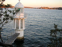
Robertson Point Light 

Location Cremorne Point, New South Wales, Australia Coordinates 33°50′55.62″S 151°13′58.85″E / 33.8487833°S 151.2330139°ECoordinates: 33°50′55.62″S 151°13′58.85″E / 33.8487833°S 151.2330139°E Year first constructed 1910 Foundation rock Tower shape round , lantern, gallery Markings / pattern white Height 26 feet (7.9 m) Focal height 25 feet (7.6 m) Range 5 nautical miles (9.3 km) Characteristic Oc.G. 3s Admiralty number K2664 NGA number 111-6220 ARLHS number AUS-176  Robertson Point Light.
 Historic view of the lighthouse, note the different light source
Robertson Point Light, also known as Cremorne Point Light, is an active lighthouse in Cremorne Point, a suburb on the lower North Shore of Sydney, New South Wales, Australia. It is the sibling of Bradleys Head Light.
The lighthouse is mounted on a rock and connected to shore by a footbridge.
The light characteristic shown is a green occulting light with a cycle of three seconds (Oc.G. 3s), the same as Bradleys Head Light.
Contents
Site operation
The light is operated by the Sydney Ports Corporation, while the site is managed by the North Sydney Municipal Council as part of the Cremorne Point Reserve.
Visiting
The site is open and accessible to the public, but the tower itself is closed. Parking is available at the end of Milson Road in Cremorne Point.
See also
- List of lighthouses and lightvessels in Australia
References
- (PDF) List of Lights, Pub. 111, The West Coasts of North and South America (Excluding Continental U.S.A. and Hawaii), Australia, Tasmania, New Zealand, and the Islands of the North and South Pacific Oceans. List of Lights. United States National Geospatial-Intelligence Agency. 2009. p. 127. http://msi.nga.mil/MSISiteContent/StaticFiles/NAV_PUBS/NIMA_LOL/Pub111/Pub111bk.pdf. Listed as "Cremorne Point" and not to be confused with "Robertson Point" listed on p. 106.
- Rowlett, Russ. "Lighthouses of Australia: New South Wales". The Lighthouse Directory. University of North Carolina at Chapel Hill. http://www.unc.edu/~rowlett/lighthouse/nsw.htm. Retrieved 2010-08-29.
External links
- "List of Lighthouses of New South Wales". Lighthouses of Australia. Lighthouses of Australia Inc. http://www.lighthouse.net.au/lights/NSW/Index%20NSW.asp.
- Searle, Garry. "List of Lighthouses - New South Wales". Lighthouses of Australia. SeaSide Lights. http://www.seasidelights.com.au/state.asp?fState=NSW.
Lighthouses of New South Wales and Jervis Bay Territory North Coast Fingal Head • Cape Byron • Richmond River • Clarence River • North Solitary Island • South Solitary Island • Smoky Cape • Tacking Point • Crowdy Head • Sugarloaf Point • Nelson Head • Point Stephens • Nobbys Head • Norah Head
Outside Sydney Harbour Inside Sydney Harbour Grotto Point • Bradleys Head • Fort Denison • Robertson Point • Parriwi Head • Eastern Channel • Western Channel • Vaucluse Bay - Front • Vaucluse Bay - Rear • Shark IslandSouth Coast Wollongong Head • Wollongong Breakwater • Kiama • Crookhaven Heads • Point Perpendicular • Cape St George • Warden Head • Burrewarra Point • Montague Island • Green CapeSee also: List of lighthouses and lightvessels in AustraliaCategories:- Lighthouses in Sydney
- 1910 architecture
- 1910 establishments in Australia
- Lighthouse stubs
- Australian building and structure stubs


Wikimedia Foundation. 2010.