- Crenshaw, Los Angeles
-
Crenshaw (also known as The Crenshaw District) is a neighborhood and district in southwestern Los Angeles, California. It derives its name from Crenshaw Boulevard, one of the city's principal thoroughfares.


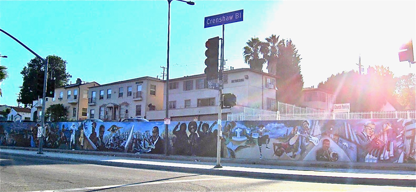
Mural of African-American Progress, Crenshaw Boulevard Contents
Crenshaw is bordered by Chesterfield Square on the east, Hyde Park on the south, View Park-Windsor Hills on the west. It includes Leimert Park. The district's boundaries are roughly Van Ness and Arlington Avenues on the east, Exposition Boulevard on the north, La Brea Avenue near Baldwin Hills on the west, and roughly Stocker Street & Slauson Avenue on the south. The Crenshaw Strip is the area directly on Crenshaw between Exposition Boulevard on the north and Vernon Avenue on the south.
Education
The area is part of the Los Angeles Unified School District. Crenshaw High School, which is south of Martin Luther King Boulevard and east of Crenshaw Boulevard, is the local public secondary school.
Charter schools in the area include the KIPP KIPP Academy of Opportunity[1] middle school, Celerity Nascent Charter School[2] the New Design Charter School (built in 2004), the View Park Preparatory Charter High School,[3] and the View Park Preparatory Charter Middle School.[4]
Neighborhood
Crenshaw is a largely residential area of single-story Mediterranean bungalows and low-rise apartment buildings, with an industrial corridor along Jefferson Boulevard.
Developed from the early 1920s onward, Crenshaw was initially a very diverse neighborhood of Whites (including many Jewish Americans and other Eastern Europeans). Covenants on property deeds barred African Americans and Asian Americans from owning real estate in Crenshaw. During preparations for the 1932 Summer Olympics, which heralded Los Angeles's arrival as a major world city, Crenshaw's medians and sidewalks were planted with hundreds of the towering palms that, to this day, dominate the area's otherwise low-rise skyline.
After courts ruled segregation covenants to be unconstitutional, the area opened up to other races. A large Japanese American settlement ensued, their neighborhood can still be found along Coliseum Street, east and west of Crenshaw Boulevard. African Americans started arriving in the 1960s and by the 1970s, they were the majority.
Since the 1970s, Crenshaw and neighboring Leimert Park have formed one of the largest African American neighborhoods in the United States, despite heavy damage from the 1992 riots and the 1994 Northridge earthquake. Crenshaw has some areas with high poverty rates such as Baldwin Village.
The population of Crenshaw in 2006 was around 27,600. Recently, with increased middle-class African American migration to newer neighborhoods such as the Antelope Valley, Moreno Valley and other areas of the Inland Empire Still, African Americans make up 63.34% of the population, followed by Latinos, 30%,[5], White, 16.89%, Asian, 4.37%, American Indians, 0.43%, Native Hawaiian and other Pacific Islanders, 0.20%, other races, 9.20%, two or more races, 9.32%.
Notable buildings
The Crenshaw district is known for the Baldwin Hills Crenshaw Plaza shopping mall, which is home to a tri-level Wal-Mart (formerly a Broadway store and later Macy's), a Sears and a Macy's, as well as many smaller stores. A bid to bring Nordstrom to the mall did not work out. The West Angeles Church of God in Christ, on the corner of Crenshaw and Exposition, is home to Bishop Charles E. Blake.
A misconception is that Crenshaw Christian Center is located in the Crenshaw district. Crenshaw Christian Center is actually located at 7901 Vermont Avenue in Los Angeles. The church was originally situated in the Morningside Park district of Inglewood on Crenshaw Boulevard at Hardy Street.
The "Crenshaw Square" sign, a local landmark, had been in serious disrepair for years. In 2007, it was replaced by a modern red-and-green sign that lights up at night.
Santa Barbara Plaza is a shopping center in the district. This aging center is in disrepair and is a failed redevelopment project, for which much money has been spent but little has been achieved.[6]
The Holiday Bowl was a center of activity during the 60s and 70s in Crenshaw. It featured a sushi bar known as the Sakiba Lounge with live musical acts. Its historic Googie architecture has been retained by the new Starbucks in that location.
Crenshaw Boulevard
Crenshaw Boulevard is a major thoroughfare for Los Angeles County. It starts at Wilshire Boulevard in Hancock Park and passes several demographically diverse areas to end in Rolling Hills. Tracks for the No. 5 Los Angeles Railway "yellow" streetcars[7] in the 1920s through 1950s ran in the median between Leimert Boulevard[8] on the north to near Florence Avenue on the south. Since the abandonment of the streetcars, the former railway median has been narrowed, the driving lanes improved and the street reconfigured. Because of its large black community, the name "Crenshaw" has become associated with African-American culture, and the area has often been referred to as the 125th Street, or Harlem of the west.
Crenshaw Boulevard has been mentioned in rap songs by artists Eazy-E, Nas, 2Pac, DJ Quik, Raekwon from the Wu-Tang Clan, Dr. Dre, Skee-Lo, Booba, The Game and Nipsey Hussle.
Crenshaw is the neighborhood that the film Boyz n the Hood is based upon. Almost the entire film was filmed in the neighborhood, as well as other places in South Los Angeles.
Metro Local lines 40 and 210, Metro Rapid lines 710 and 740, and Torrance Transit line 5 serve Crenshaw Boulevard; Metro lines 210 and 710 run through the majority of Crenshaw Boulevard to Artesia Boulevard, Metro lines 40 and 740 from Crenshaw District to Hyde Park, and Torrance Transit line 5 south of Artesia Boulevard. The Metro Green Line serves a station on Crenshaw Boulevard underneath Interstate 105. Plans are currently in the works to restore rail service along Crenshaw with a proposed Crenshaw Corridor line and for an Expo Line station.
In the Crenshaw district, Crenshaw Boulevard and Baldwin Hills Crenshaw Plaza are served primarily by LADOT and four Los Angeles County Metropolitan Transportation Authority bus lines:
-
- Metro Local 40 / Rapid 740 - South Bay Galleria - Patsaouras Transit Plaza via Hawthorne Boulevard and Martin Luther King Boulevard
- Metro Local 210 - South Bay Galleria - Hollywood/Vine Station via Crenshaw Boulevard, Rossmore Avenue, and Vine Street
- Metro Rapid Line 710 - South Bay Galleria - Wilshire/Western Station via Redondo Beach Boulevard and Crenshaw Boulevard
Crenshaw Boulevard is also briefly served in the Crenshaw district by the following LACMTA lines:
-
- Metro Local 42 - Los Angeles International Airport to Patsouras Transit Plaza via King Boulevard, Stocker Street, and La Tijera Boulevard
- Metro Local 105 / Rapid 705- West Hollywood - Vernon via La Cienega Boulevard, Rodeo Road, and Vernon Avenue
- Metro Limited 305 - UCLA - Wilmington/Imperial/Rosa Parks Station (Crosstown)
Notable residents and natives
- Arthur Lee, rock singer
- Darryl Strawberry, professional baseball player
- Eric Davis, professional baseball player
- Tremaine Fowlkes professional basketball (NBA).
- Ice Cube, rapper and actor
- Ice-T, rapper and actor
- James Hahn, mayor of Los Angeles, 2001–2005
- Kenneth Hahn, (1920–1997) Los Angeles County supervisor
- Lords of Lyrics, rap group
- Nipsey Hussle, rapper
- Pam Ward, designer/author of Want Some Get Some, a Los Angeles novel
- Saaphyri Windsor, reality television star, winner of "Flavor of Love Girls: Charm School."
- Skee-lo, rapper
- OFWGKTA, Hip-Hop collective
- Tom Bradley, mayor of Los Angeles, 1973-1993
- Richard Elfman and Danny Elfman, sibling musicians (The Mystic Knights of the Oingo Boingo/Oingo Boingo)
References
- ^ http://www.kippkao.org/
- ^ http://www.celerityschools.org/
- ^ http://vpphs.icefla.org/
- ^ http://vppms.icefla.org/
- ^ Robinson-Jacobs, Karen, "Noticing a Latin Flavor in Crenshaw," Los Angeles Times 2 May 2001: D1.
- ^ Urban renewal project in L.A. begets blight instead - By Ted Rohrlich, Los Angeles Times Staff Writer 10:38 PM PDT, April 27, 2008
- ^ Los Angeles Railway in Brief - Map of Streetcar Routes
- ^ 5 Line
External links
- Leimert Park Beat is a collaborative online community
South Los Angeles region, Los Angeles Districts and
neighborhoodsBaldwin Hills · Baldwin Village · Baldwin Vista · Canterbury Knolls · Chesterfield Square · Crenshaw · Hyde Park · Jefferson Park · King Estates · Leimert Park · University Park · Vermont Square · Watts · West Adams
Points of
interestSee also Downtown · Eastside/Northeast · Harbor Area · Greater Hollywood · Westlake/Silver Lake/Los Feliz · San Fernando and Crescenta Valleys · South Los Angeles · Westside · WilshireCategories:- Neighborhoods in Los Angeles, California
- Populated places in California with African American majority populations
-
Wikimedia Foundation. 2010.