- Crooks' Hollow Dam
-
Crooks' Hollow Dam 
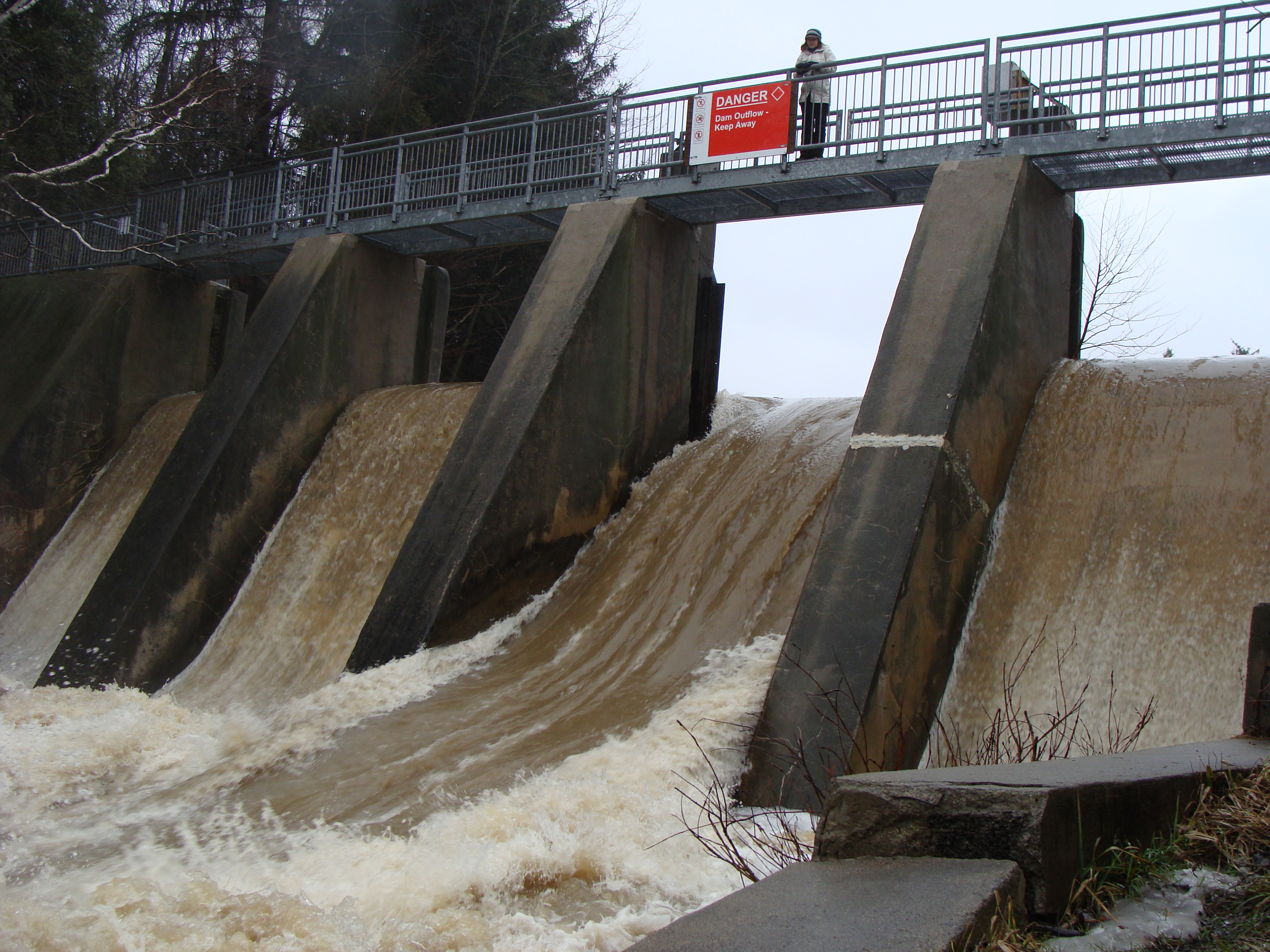
Crooks Hollow Dam with all 4 spillways in action on March 14, 2010. On this day, HCA’s upstream measuring station at Christie Conservation Area recorded 67.5 mm of rain.[1]Location of Crooks' Hollow Dam

Country Canada Location Greensville, Ontario Coordinates 43°16′43″N 79°59′47″W / 43.27861°N 79.99639°WCoordinates: 43°16′43″N 79°59′47″W / 43.27861°N 79.99639°W Status Operational Opening date 1916 Dam and spillways Height 17.5 feet (5 m) Length 100 feet (30 m) Crooks' Hollow Dam (alternatively, Dundas Town Dam) is a buttressed gravity dam, built of concrete in 1916[2] on Spencer Creek in Greensville, Ontario, Canada. About 100 yards upstream from the ruins of the much earlier Cockburn sawmill and dam,[3] it replaced that dam in supplying water by pipe to Dundas for all uses. It also provided much greater flood control, and, more than the Cockburn dam, supplied a managed flow for water power users in the industries downstream. The Dundas Star commented on its completion: "... an excellent piece of work. It is now hoped there will be no further difficulty about securing an adequate water supply for many years to come."[4]
Contents
Design and construction
The dam was built in such a way that pure, cool water was drawn from the bottom of the reservoir for the existing pipe[5] to Dundas; and for impure, warmed water to be sent over the spillways for industrial use downstream. The dam was created with reservoir expansion in mind, from 10,000,000 to 15,000,000 gallons, by the simple addition of another 3 feet of stoplogs.[2][5]
Local professionals built the dam. The consulting engineer was E.H. Darling (of McPhee, Kelly and Darling, Bank of Hamilton Building, Hamilton, Ont.). The general contractor was McAllister and Taylor (#37, Sun Life Building, Hamilton). They completed the project without overrunning its budget of $6,300.[2] Expropriation of the south-bank Hunt and west-end Morden properties was extra.
Features
Features of the dam include, or included in 1916:
- 100 feet long and 17½ feet high with 3 more feet of height possible[2]
- "a massive monolithic concrete construction"[2]
- incorporated "0.8 m thick base/key under the dam which provides sliding resistance on the d/s [downstream] key face and increases the weight of the dam" [6]
- 1-foot-thick stoplogs could be inserted to raise the level of any or all of 4 spillways in many configurations
- a fifth route to ease overtopping water levels, along the left wing wall, which is no higher than the original design operating level
- much earlier Morden dam pond, with its berm and ruins, usually has the same water level as the reservoir and, therefore, is continuous with it
- on top of the spillway columns, a bridge connecting "downtown" Greensville to a path to Kirby Avenue and a branch of Hamilton Public Library (bridge replaced about 1995) provides greater vistas upstream and downstream
- large reservoir to supply Dundas and "power users below [dam]" throughout dry summers[2]
- flood prevention (floods had plagued Dundas over the previous century[7])
- reservoir formed "a splendid natural settling basin", saving on filtration[2]
- Dundas was to save the cost of the dam in pumping alone every year[2]
- "To protect the water as much as possible", a wire fence was built on the south side of the reservoir and a tight board fence on the north.[5] The wire fence is still in evidence.
The dam today
The dam's impoundment, or reservoir, has been the subject of much photographic interest for its tranquil, picturesque beauty, especially in the autumn. Recreational activities at the dam that have occupied at least three Greensville generations include fishing, birding, walking the trails, picnicking, boating and swimming (historically).
The entire Crooks' Hollow, which was named after James Crooks and was Upper Canada's first industrial park in the 19th century,[8] is noteworthy for offering nature in an unmanaged state (only dangerous dead trees are cut down), with a wide variety of avian, animal, amphibian and piscine life. The Hollow is also noteworthy for its freedom from noise (excepting the steady roar of the spillways), from commercialization and from litter. Ruins of past water-power industries are plentiful, and have sometimes been used for educational purposes. The dam itself has that potential.
Controversy and demolition
In 1969 the Hamilton Region Conservation Authority established Crooks' Hollow as its first Conservation Area, with "extensive restoration" of the dam.[9] In September 2008 its successor, the Hamilton Conservation Authority slated the dam for demolition. The Authority's environmental assessment has been upheld by the Ontario Ministry of the Environment.[10] In December 2010, the Authority stated the dam's demolition and the creek's rehabilitation would begin in 2011 and end in 2012. This is motivated by environmental concerns along with fears that the dam could fail during or after a major storm. Hundreds of residents and Facebook supporters wish to preserve the dam and its reservoir for recreational, aesthetic and heritage purposes.[11]
Notes
- ^ Flamborough Review article Downpour floods area roads, March 18, 2010
- ^ a b c d e f g h Dundas Star, 2 Nov. 1916, p. 1.
- ^ Dundas had secured options on the Cockburn property in 1909 (Dundas Star, 9 June 1909, p. 1).
- ^ Dundas Star, 26 Oct. 1916, p. 4.
- ^ a b c Karch and Mount, P.U.C., to Dundas Town Council, 19 April 1915.
- ^ Peto MacCallum report, p. 11.
- ^ Aikman, "Crooks' Hollow: A Study of Change", App. B.
- ^ The name Crooks' Hollow was applied only to the western end when James Crooks established his industrial empire. Wodell's chapter (p. 101) has only the Stutt (or Darnley) paper mill surviving in the Hollow by 1897. Later the name came to include the ruins of the many downstream industries. Crooks' Hollow now extends from the Darnley Mill ruins to at least the old Kerby dam just before the Brock Road bridge.
- ^ H.R.C.A., "Annual Report 1969", p. 21.
- ^ M.O.E. to H.C.A., 13 May 2009.
- ^ Wong, Danielle (20 Dec 2010). "Crooks’ Hollow Dam to be demolished in two years". TheSpec. http://www.thespec.com/news/local/article/303775--crooks-hollow-dam-to-be-demolished-in-two-years. Retrieved 1 January 2011.
References
- 1897. J.E. Wodell, "Industrial Ruins in Crooks' Hollow", in R.K. Kernighan et al., Pen and Pencil Sketches of Wentworth Landmarks (Hamilton: The Spectator Printing Co.), pp. 100–2.
- 1909. "Purchasing Cockburn Dam Property; There'll Be Big Savings to the Town If This Deal Goes Through", Dundas Star, 9 June.
- 1915. R.W. Karch and Wm. Mount, Public Utilities Commission of Dundas, to Dundas Town Council, 19 April (Dundas Town archives).
- 1916. "The Town Water Supply" [editorial], Dundas Star, 26 Oct., p. 4.
- 1916. "Greensville Dam Now Finished; It Is a Fine Piece of Work and Should Ensure Plenty Water for Many Years to Come", Dundas Star, 2 Nov., p. 1.
- 1950. Township of West Flamborough, Province of Ontario: 1850 - 1950 Centennial Celebration; A Record of the One Hundred and One Years Since the Township Was Incorporated (printed by Dundas Star; 218 pp.).
- 1965. Thomas M. Thomson, The Spencer Story ([Dundas?, Ont.: Public Relations and Education Board, Spencer Creek Conservation Authority).
- 1969. Hamilton Region Conservation Authority, "Annual Report 1969".
- 1977. John H. Aikman, "Crooks' Hollow: A Study of Change" (Student's Handbook, Board of Education for the City of Hamilton; 1974, revised). Available at Flamborough Archives and Dundas Archives.
- 1993. Peto MacCallum Ltd, Consulting Engineers. "Crooks Hollow Dam Integrity Assesssment, Crooks' Hollow Road, Town of Flamborough, Ontario, for Hamilton Region Conservation Authority". Available at HCA office, Ancaster, Ont.
- 2008. Hatch Energy. "Class Environmental Assessment Project Plan: Crooks' Hollow Dam; Draft Report". October.
- 2009. John Gerretsen, Ontario Minister of the Environment, to Hamilton Conservation Authority, 13 May.
See also
Categories:- Buildings and structures in Hamilton, Ontario
- Reservoirs in Canada
- Dams in Ontario

Wikimedia Foundation. 2010.