- Cuchumuela
-
Cuchumuela — Town — Location within Bolivia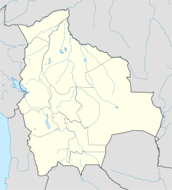
 Cuchumuela
Coordinates: 17°38′S 65°47′W / 17.633°S 65.783°WCoordinates: 17°38′S 65°47′W / 17.633°S 65.783°W Country  Bolivia
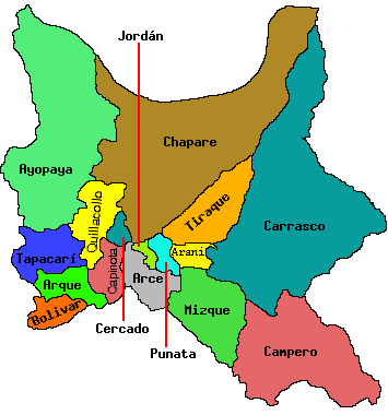
Department Cochabamba Department Province Punata Province Municipality Cuchumuela Municipality Foundation Government – Mayor David Guevara Velasquez (2007) – President Vitaliano Ovando Velarde (2007) Population (2001) – Total 448 Time zone -4 (UTC-4) Cuchumuela or Khuchumuela is a location in the Cochabamba Department in central Bolivia. It is the seat of the Cuchumuela Municipality, the fifth municipal section of the Punata Province.
References
 Cochabamba Department
  Capital: Cochabamba
Provinces Arani • Arque • Ayopaya • Bolívar • Capinota • Carrasco • Cercado • Chapare • Esteban Arce •Germán Jordán • Mizque • Narciso Campero • Punata •Quillacollo • Tapacarí • Tiraque
Municipalities (and seats) Aiquile (Aiquile) • Alalay (Alalay) • Anzaldo (Anzaldo) • Arani (Arani) • Arbieto (Arbieto) • Arque (Arque) • Ayopaya (Ayopaya) • Bolívar (Bolívar) • Capinota (Capinota) • Chimoré (Chimoré) • Cliza (Cliza) • Cocapata (Cocapata) • Cochabamba (Cochabamba) • Colcapirhua (Colcapirhua) • Colomi (Colomi) • Cuchumuela (Cuchumuela) • Entre Ríos Municipality (Entre Ríos) Mizque (Mizque) • Morochata (Morochata) • Omereque (Omereque) • Pasorapa (Pasorapa) • Pocona (Pocona) • Pojo (Pojo) • Puerto Villarroel (Puerto Villarroel) • Punata (Punata) • Quillacollo (Quillacollo) • Sacaba (Sacaba) • Sacabamba (Sacabamba) • San Benito (San Benito) • Santiváñez (Santiváñez) • Shinahota (Shinahota) • Sicaya (Sicaya) • Sipe Sipe (Sipe Sipe) • Tacachi (Tacachi) • Tacopaya (Tacopaya) • Tapacarí (Tapacarí) • Tarata (Tarata) • Tiquipaya (Tiquipaya) • Tiraque (Tiraque) • Toco (Toco) • Tolata (Tolata) • Totora (Totora) • Vacas (Vacas) • Vila Vila (Vila Vila) • Villa Rivero (Villa Rivero) • Villa Tunari (Villa Tunari) • Vinto (Vinto)
Categories:- Populated places in the Cochabamba Department
- Cochabamba Department, Bolivia geography stubs

Wikimedia Foundation. 2010.