- Ansty and Staplefield
-
Coordinates: 51°00′08″N 0°10′40″W / 51.00214°N 0.17767°W
Ansty and Staplefield 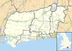
 Ansty and Staplefield
Ansty and Staplefield shown within West SussexArea 38.69 km2 (14.94 sq mi) [1] Population 1,574 [1] 2001 Census - Density 41 /km2 (110 /sq mi) OS grid reference TQ279241 - London 35 miles (56 km) N Parish Ansty and Staplefield District Mid Sussex Shire county West Sussex Region South East Country England Sovereign state United Kingdom Post town HAYWARDS HEATH Postcode district RH17 Dialling code 01444 Police Sussex Fire West Sussex Ambulance South East Coast EU Parliament South East England UK Parliament Mid Sussex Horsham Website http://www.anstystaplefield-pc.gov.uk/ List of places: UK • England • West Sussex Ansty and Staplefield, formally Cuckfield Rural,[2] is a civil parish in the Mid Sussex District of West Sussex, England, covering an area from the north-west side of Burgess Hill, the whole lying to the west of Cuckfield civil parish, from which it was created in 1894 under the Local Government Act 1894. It includes the settlements of Ansty, Staplefield and Brook Street. It is the largest civil parish in West Sussex, covering an area of 3869 ha, and has a population of 1574 persons (2001 census).
References
- ^ a b "2001 Census: West Sussex – Population by Parish". West Sussex County Council. http://www.westsussex.gov.uk/communityandliving/census2001/pop_parish_summary.pdf. Retrieved 1 April 2009.
- ^ "Minutes of a Meeting of Mid Sussex District Council". Mid Sussex County Council. 15 October 2008. pp. pp.5 (item 70). http://www.midsussex.gov.uk/Nimoi/sites/msdcpublic/resources/0810152.pdf. Retrieved 29 May 2009.
Categories:- West Sussex geography stubs
- Mid Sussex

Wikimedia Foundation. 2010.