- Culcheth Methodist Church
-
Coordinates: 53°27′15.3″N 2°31′15.9″W / 53.45425°N 2.521083°W Culcheth Methodist Church is located in the village of Culcheth, now a part of Warrington, England. The church building is located at the corner of Ellesmere Road and Burton Close near the village centre, a short walk from the village green.
Contents
Foundation
The church was founded in the 1950s as a home worship group in the rapidly expanding village as the village became a residence area to workers in the newly established Atomic Energy industry[1] at Risley[2] by Methodists from the nearby village of Glazebury, where a much older Methodist Church was and is based on the Warrington Road, Glazebury. Now the church has expanded to be the largest Methodist church in the local area. The church is part of the Leigh and Hindley Circuit, which is currently (circa late 2009) under review and change.[3]
Independent charity
In 2009 the church became an independent charity, registered with the Charity Commission of England and Wales. Registered Charity Number 1129901.[4] Previously the church was a charity under the statutory regulations giving charitable status to all Methodist Churches.[5]
Delta shape, Δ, and bell
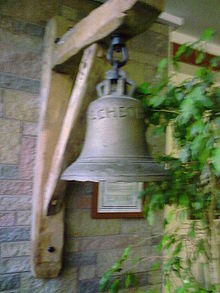 Culcheth Hall Bell
The church sanctuary is somewhat exceptional in being of a triangular shape ("Δ") much like the sweets called "Toblerone" and being the first modern church, since the English reformation inside the old Culcheth village area. The older village area under its squire was recusant and thus the Church of England church serving the village was outside the village area controlled by the squire at Newchurch. The local Roman Catholic church also being outside the village leaves an old[6] settlement with a very recent church inside the village. The Culcheth Methodist Church is now home to the old bell from Culcheth Hall chapel, the squire's private catholic chapel, which has passed through the other churches to Culcheth Methodist Church for safekeeping, and is in regular use as it is rung to announce services and continuation of worship in many forms in the village.
See also
References
- ^ http://www.nnl.co.uk/locations/risley.html
- ^ http://www.british-towns.net/en/level_4_display.asp?GetL3=14865
- ^ Leigh and Hindley Circuit of the Methodist Church of Great Britain
- ^ Refer to Charity Commission website for aims and trustees
- ^ An exempt charity under statutory instrument 2002 no. 1598
- ^ http://www.culcheth.org/history1.htm Local History Notes
External links
Categories:- Warrington
- Methodist churches in England

Wikimedia Foundation. 2010.