- Dolmen of Cunha Baixa
-
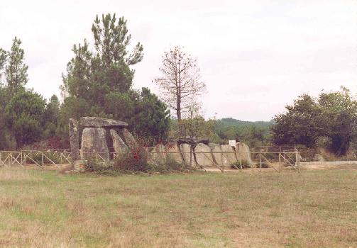
Dolmen of Cunha Baixa (Anta de Cunha Baixa) Casa da Orca Dolmen (Anta)  Profile of the dolmen, showing main chamber (centre-left) and corridor (right)
Official name: Anta de Cunha Baixa/Casa da Orca Named for: the civil parish of Cunha Baixa Country  Portugal
Region Centro Region Sub-region Dão-Lafões District Viseu Municipality Mangualde Location Cunha Baixa - elevation 491 m (1,611 ft) - coordinates 40°34′2.23″N 7°44′59.56″W / 40.5672861°N 7.7498778°W Length 3 m (10 ft), Southwest-Northeast Width 10.2 m (33 ft), Northwest-Southeast Height 3.2 m (10 ft) Area 10.4 m2 (112 sq ft) Architects unknown Style Megalithic Material Granite Discovered c. 1892 - Earliest 3000 A.D. - Last 2500 A.D. Owner Portuguese Republic For public Private Visitation Closed Management Instituto Gestão do Patrimonio Arquitectónico e Arqueológico Status National Monument Listing Decree 16 June 1910; DG 136, 23 June 1910 Wikimedia Commons: Anta de Cunha Baixa The Dolmen of Cunha Baixa (Portuguese: Anta de Cunha Baixa) is a dolmen in the civil parish of Cunha Baixa, in the municipality of Mangualde. It is lcoated in a valley area of the Rio Castelo, between the villages of Cunha Baixa and Espinho.
History
From artifacts discovered in and around the archaeological excavations, scientists have determined that it was constructed between 3000 and 2500 A.D.[1]
It was discovered in 1892, by Leite de Vasconcelos, who first documented the dolmen, under the authority of Dr. Pais da Cunha, then owner of the property.[1] He found the dolmen damaged, with the interior chambers full of dirt, brambles and rocks of various sizes, some eroded or damaged from the dolmen itself. They proceeded to clean-out the chambers and excavate to about 1.17 metres, discovering the first archaeological objects, and then continuing to the table rock. In these excavations Leite de Vasconcelos found in the interior of the dolmen, axes and polished trapezoidal-shaped polished stone adzes; rudely carved flint blades, trapezoidal microliths, triangular and semi-lunar, fragments of red and black pottery, some with ornaments; yellow ocre for body painting; burnt berry seeds; burnt pieces of substances from a forge or furnace; and a human bone.[1]
At the entrance, was an inclined rock slab 1.2 metres by 0.2 metres, with 15 grooves along its edge on both sides. Also in the adjacent terrain, a flint axe, a polished stone implement, six small blades (some jagged) and flint arrowheads, were also discovered.[1] The artifacts were transferred to the National Archaeological Museum (Portuguese: Museu Nacional de Arqueologia) in Lisbon.
It was declared a National Monument (Portuguese: Monumento Nacional) on 16 June 1910.
In 1934, the Leisners carried-out a plan of the site, and cut a section from the dolmen.[1] But, by 1955, I. Moita encountered the dolmen surrounded by scrub and the corridor obstructed by rocks.[1]
A restoration and cleaning of the site, under Raquel Vilaça and Domingos Cruz (1987), solicited the A.C.A.B. and the Central Region Archaeological Service (Portuguese: Serviço Regional de Arqueologia da Zona Centro), with authorization from the IPPC.[1] A similar cleaning was undertaken in 1994 that included cleaning the monument and the area circling the site.[1]
Architecture
Located along the municipal roadway connecting Cunha Baixa with Espinho, the site is 0.8 kilometres along a footpath to a bridge: 300 metres by foot between two properties in the locality of Orca, or Casa da Moura.[1] It is situated in a rural, fertile plain alongside a river, isolated from view and encircled by vineyards to the south and east, and pine forests to north and northwest, delimited by a wood and wire fence.
Cunha Baixa comprises a main chamber and corridor, although there are no remnants of body within its chamber. The dolmen, is a large polygonal shape enclosure, covered by a great slab of rock, of similarly large dimensions.[2][1] This main chamber is 3 metres wide, and 3.2 metres high, formed from 9 vertical slabs, some fractured or incomplete.[1] The entrance rock is parallel to the main stone and inclined towards the interior. The roof-stone is a long rounded rectangular slab, 4.5 metres in diameter.[1]
The corridor is 7.20 metre long, at a height of 1.40 metres, oriented along the southeast of the main chamber.[1] It is built from 8 vertical slabs on either side (a few reinforced by steel beams), forming side-walls that are wider in the mid-area and converge slightly towards the main chamber entrance.[1] The vertical slabs are largely square, although some trapezoid and triangular rock pieces are located in the chamber. At the middle of the corridor, another trapezoidal roof slab, smaller then the first covers only the middle part of the corridor.[1]
The pavement of the dolmen is regular, composed of granite rock, with a total surface area of 10.4 metres.[1]
In some places there are remnants of carvings (or vestiges), such as pitting or scaring.[1]
References
- Notes
- ^ a b c d e f g h i j k l m n o p q Marques, Lina (1995). "Anta da Cunha Baixa/Casa da Orca". In SIPA (in Portuguese). Lisbon, Portugal: SIPA – Sistema de Informação para o Património Arquitectónico. http://www.monumentos.pt/Site/APP_PagesUser/SIPA.aspx?id=2378. Retrieved 20 October 2011.
- ^ IGESPAR, ed (2011). "Anta de Cunha Baixa" (in Portuguese). Lisbon, Portugal: IGESPAR-Instituto de Gestão do Património Arquitectónico e Arqueológico. http://www.igespar.pt/en/patrimonio/pesquisa/geral/patrimonioimovel/detail/70677/. Retrieved 20 September 2011.
- Sources
- Vasconcelos, Leite de (1897) (in Portuguese), Religiões da Lusitânia, I, Lisbon, Portugal, pp. 271-272
- Vasconcelos, Leite de (1904), "Arqueologia Pré-Histórica da Beira", O Arqueólogo Português, IX, Lisbon, Portugal, pp. 303-308
- Silva, Valentim da (1945) (in Portuguese), Concelho de Mangualde (Antigo Concelho de Azurara da Beira), Viseu, Portugal
- Moita, Irisalva (1966) (in Portuguese), Características Predominantes do Grupo Dolménico da Beira Alta, Lisbon, Portugal
- Campos, José A. Correia de (1982), "Dólmens: Habitações ou Necrópoles?" (in Portuguese), Beira Alta, XLI, Viseu, Portugal, pp. 167-188
- Vilaça, Raquel; Cruz, Domingos (1990) (in Portuguese), A Casa da Orca da Cunha Baixa, Mangualde, Portugal
Freguesias Abrunhosa-a-Velha · Alcafache · Chãs de Tavares · Cunha Alta · Cunha Baixa · Espinho · Fornos de Maceira Dão · Freixiosa · Lobelhe do Mato · Mangualde · Mesquitela · Moimenta de Maceira Dão · Póvoa de Cervães · Quintela de Azurara · Santiago de Cassurrães · São João da Fresta · Travanca de Tavares · Várzea de TavaresHeritage sites Cunha Baixa Dolmen · Mesquitela House · Santa Maria de Maceira Dão MonasteryOther buildings and structures Nossa Senhora do Castelo Chapel
Categories:- Megalithic monuments in Portugal
- National monuments in Portugal
Wikimedia Foundation. 2010.