- Cyclone Herbie
-
Tropical Cyclone Herbie Category 1 cyclone (Australian scale) Tropical storm (SSHS) 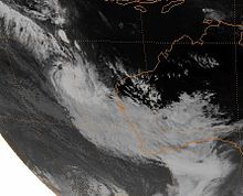
Cyclone Herbie approaching Western Australia on 20 May Formed 17 May 1988 Dissipated 21 May 1988 Highest winds 10-minute sustained:
75 km/h (45 mph)
1-minute sustained:
65 km/h (40 mph)
Gusts:
120 km/h (75 mph)Lowest pressure 980 mbar (hPa; 28.94 inHg) Fatalities None reported Damage $15.6 million (1988 USD) Areas affected Western Australia Part of the 1987–88 Australian region cyclone season Tropical Cyclone Herbie was the only known tropical system to impact Western Australia during the month of May on record. The final cyclone of the 1987–88 Australian region cyclone season, Herbie was first identified northwest of the Cocos Islands on 17 May. The following day, the system was classified as a tropical low by the Australian Bureau of Meteorology and intensified into a Category 1 cyclone later that day. Several hours after this upgrade, the storm attained its initial peak intensity with winds of 75 km/h (45 mph 10-minute sustained). Around the same time, the Joint Typhoon Warning Center classified Herbie as Tropical Storm 21S.
On 19 May, the cyclone formed a new low pressure center and relocated roughly 300 km (190 mi) south. Shortly thereafter, the storm began to accelerate towards the southeast and started to undergo an extratropical transition. Early on 21 May, Herbie made landfall in Shark Bay before losing its identity the following day over the Great Australian Bight. Although a weak storm, Herbie brought flooding rains and severe dust storms to portions of Western Australia. Additionally, a 30,000 ton freighter broke in half amidst rough seas produced by the storm. Total losses from the storm reached A$20 million ($15.6 million USD). Due to the significant damage wrought by Herbie, the name was retired following its use.
Contents
Meteorological history
 Storm path
Tropical Cyclone Herbie originated from an area of low pressure on 17 May 1988 northwest of the Cocos Islands. Later that day, the Australian Bureau of Meteorology began monitoring the system as a tropical low.[1] Several hours after, the Joint Typhoon Warning Center (JTWC) classified the system as Tropical Depression 21S, having attained winds of 45 km/h (30 mph 1-minute sustained).[2] Following slight development, the system intensified into a Category 1 cyclone and was given the name Herbie by the Australian Bureau of Meteorology early on 18 May.[1][3] Several hours after being named, the storm attained its initial peak intensity with winds of 75 km/h (45 mph 10-minute sustained) and a barometric pressure of 990 hPa (mbar).[3]
Around the same time, the JTWC upgraded the system to a tropical storm, estimating the cyclone to have attained peak winds of 65 km/h (40 mph 1-minute sustained).[2] On 19 May, satellite imagery of the system depicted that a new low pressure centre had developed roughly 300 km (190 mi) south of the original low.[1] Several hours after the relocation, the JTWC downgraded Herbie to a tropical depression as the system's movement began to accelerate towards the southeast.[1][2] As the storm moved at a rapid speed towards the coastline of Western Australia, it began to undergo an extratropical transition. During a 24-hour period (20–21 May) Herbie tracked roughly 1,500 km (930 mi), with the movement of the storm reaching 70 km/h (43 mph) at times.[1]
Late on 20 May, the JTWC ceased advisories on the system as it weakened below tropical depression status offshore.[2] However, the Bureau of Meteorology continued to monitor the system. Early on 21 May, the center of Herbie made landfall in Shark Bay with wind gusts up to 120 km/h (75 mph) and a pressure of 980 hPa (mbar). Due to the rapid movement of the storm, it reached the Great Australian Bight while retaining tropical characteristics despite its low-latitude. Early on 22 May, the system lost its identity south of Australia as an extratropical cyclone.[1]
Impact
Although a weak storm, Herbie caused moderate structural damage across Western Australia in coastal areas between Carnarvon and Denham and banana plantations sustained extensive damage. In Denham, a storm surge of 2 m (6.6 ft) was recorded. This water rise led to several fishing vessels being brought inland and left beached on streets once the water subsided. Due to the storms extratropical transition, areas south of Herbie received moderate to heavy rainfall while areas north of the center reported severe dust storms fueled by the cyclone's high winds. Most areas affected by the storms rain recorded around 50 mm (2.0 in) with isolated totals near 100 mm (3.9 in).[1] The Irwin and Greenough Rivers overflowed their banks, inundating parts of Dongara.[4] Near Carnarvon, about A$10 million worth of crops were wiped out by the storm as 100 km/h (65 mph) winds struck plantations. Structural damage was also estimated at A$10 million.[5]
Offshore, a 30,000 ton freighter, the Korean Star, sustained extreme damage during the storm. Rough seas caused the hull of the ship to break and the vessel was separated into two pieces. Although the freighter was in two pieces, the ship did not sink and the wreckage of it came ashore near Cape Cuvier.[1] No one on the ship sustained injury as all crew members abandoned ship.[6]
In the wake of the storm, appeals were made for relief funds in regions affected by Herbie.[7] As of January 2010, Cyclone Herbie is the most recent tropical system to either directly or indirectly impact the town of Geraldton, a region that is struck by tropical cyclones once every six to eight years.[4] Although the storm caused relatively little damage, the name Herbie was retired following its usage and will never be used again to name a tropical cyclone in the Australian region.[8]
See also
- Lists of tropical cyclones
References
- ^ a b c d e f g h "Tropical Cyclone Herbie". Australian Bureau of Meteorology. 2010. http://www.bom.gov.au/cyclone/history/herbie.shtml. Retrieved 27 January 2010.
- ^ a b c d Joint Typhoon Warning Center (1989). "Cyclone 21S Best Track". United States Navy. http://www.usno.navy.mil/NOOC/nmfc-ph/RSS/jtwc/best_tracks/1988/1988s-bsh/bsh211988.txt. Retrieved 27 January 2010.
- ^ a b "Australian Region Tropical Cyclone Best Tracks". Australian Bureau of Meteorology. 2009. http://www.bom.gov.au/cgi-bin/silo/cyclones.cgi. Retrieved 27 January 2010.
- ^ a b "Tropical Cyclones Affecting Geraldton". Australian Bureau of Meteorology. 2010. http://www.bom.gov.au/weather/wa/cyclone/about/geraldton/index.shtml. Retrieved 27 January 2010.
- ^ Staff Writer (23 May 1988). "Oil Slick Spreads From Shipwreck". Sydney Morning Herald.
- ^ Associated Press (24 May 1988). "Ship breaks up". Herald-Journal. http://news.google.com/newspapers?id=8VIgAAAAIBAJ&sjid=js4EAAAAIBAJ&pg=5691,3215968&dq=cyclone+herbie&hl=en. Retrieved 27 January 2010.
- ^ "Previous Relief Appeals". The Lord Mayor's Distress Relief Fund. 2010. http://appealswa.org.au/previousappeals.html. Retrieved 27 January 2010.
- ^ "Tropical Cyclone Names". Australian Bureau of Meteorology. 2010. http://www.bom.gov.au/weather/cyclone/about/cyclone-names.shtml. Retrieved 27 January 2010.
External links
- Joint Typhoon Warning Center (JTWC).
- Australian Bureau of Meteorology (TCWC's Perth, Darwin & Brisbane).
List of retired Australian cyclone names 1960s 1970s 1980s 1990s 2000s 2010s Categories:- Retired Australian region cyclones
- Category 1 Australian region cyclones
- Cyclones in Australia


Wikimedia Foundation. 2010.