- D56 road (Croatia)
-
D56 state road
Route information Length: 122.5 km (76.1 mi) Major junctions From:  D424 in Tromilja interchange
 D27 in Benkovac
 D33 in Lozovac and in Drniš
To:  D1 in Klis-Grlo interchange
Location Counties: Zadar, Šibenik-Knin, Split-Dalmatia Major cities: Benkovac, Skradin Highway system State roads in Croatia
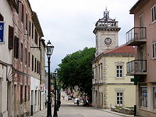 Benkovac, located on the D56 road
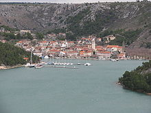 Skradin, located on the D56 road
 Skradin Bridge, carrying the D56 road
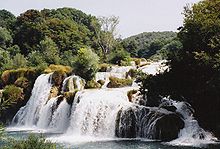 Krka National Park, accessed via D56
 Klis Fortress, near the eastern terminus of D56
D56 runs parallel to a segment of A1 motorway between Zadar and Split areas. Furthermore the road has junctions to major state roads, namely D27 in Benkovac, connecting to D1 state road in Gračac, serving as a possible bypass of both Maslenica bridges, D424, D59 and D33 state roads. The road also connects to A1 motorway Skradin and Zadar 2 interchanges via D424 and a short connector road, respectively.[1] The road is 122.5 km (76.1 mi) long.[2]
The D56 road also serves as a connection to Krka National Park.
The road, as well as all other state roads in Croatia, is managed and maintained by Hrvatske ceste, a state-owned company.[3]
Contents
Traffic volume
Traffic is regularly counted and reported by Hrvatske ceste, operator of the road.[4] Substantial variations between annual (AADT) and summer (ASDT) traffic volumes are attributed to the fact that the road serves as a connection to A1 motorway and it carries substantial tourist traffic.
D56 traffic volume Road Counting site AADT ASDT Notes  D56
D564916 Raštević 3,109 3,493 Adjacent to Ž6003 junction. D565318 Lišane Oštrovičke 742 1,200 Between L63177 and L63147 junctions. D565306 Skradin 1,930 3,058 Adjacent to Ž6090 junction. D565413 Kljake 1,362 1,568 Between Ž6098 and Ž6099 junctions. D565503 Progon - south 2,732 3,267 Between D219 and Ž6116 junctions. Road junctions and populated areas
D56 junctions/populated areas Type Slip roads/Notes 
Tromilja interchange
D424 to Zadar and A1 motorway Zadar 2 interchange.
 D502 to Zemunik Donji (to the west).
The western terminus of the road. D56 and D502 are concurrent for approximately 700 m (2,300 ft) to the east. D502 to Smilčić and Karin (to the north).
The eastern limit of D56/D502 concurrency.Ž6044 to Škabrnje 
Donje Biljane
Ž6014 to Poličnik.
Ž6258 to Smilčić and Islam Latinski.Benkovac
D27 to Stankovci (to the south) and Gračac (to the north).
D56 and D27 are concurrent for approximately 500 m (1,600 ft) in Benkovac. The southbound D27 junction is west of the northbound one.
Ž6003 to the town centre.Ž6051 to Kolarina. Ž6067 to Vukšić and Bila Vlaka. Žažvić Bribirske Mostine
 D59 to Knin (to the north) and to Pirovac (to the south).
There actually two D56/D59 intersections, the first one with the southbound D59, and the second one to the northbound section of D59. The two roads are concurrent for approximately 300 m (980 ft).Ž6073 to Piramatovci. Vaćani Gračac
Ž6089 to Sonković. A1 Skradin interchange to Zadar (to the north) and to Šibenik and Split (to the south).
The interchange is accessed via a short connector road.Skradinsko Polje Skradin
Ž6075 to Dubravice.
Skradin Bridge Ž6090 to Krka National Park. Gulin Lozovac
D33 to Šibenik (to the south). D33 and D56 to the east are concurrent.Konjevrate
Ž6092 to Unešić.Ž6093 to Pokrovnik. Ž6078 to Pakovo Selo. Ž6094 to Žitnić. Drniš
D33 to Knin (to the north). D33 and D56 to the west are concurrent.Kričke Ružić Ž6096 to Gradac. Ž6097 to Mirlović Polje and Čavoglave.
Ž6098 to Kladnice.Ž6099 to Crivac. Gornje Postinje Muć Gornji Muć
 D219 to Sinj.
Ž6116 to Neorić and Sičane. Ž6114 to Brištanovo and Nisko. Prugovo Ž6115 to Konjsko. Ž6253 to Klis. D1 in Klis-Grlo interchange to Sinj (to the north) and Split to the south.
The eastern terminus of the road.See also
- Croatian Motorways Ltd
- Krka National Park
Sources
- ^ "Regulation on motorway markings, chainage, interchange/exit/rest area numbers and names" (in Croatian). Narodne novine. May 6, 2003. http://narodne-novine.nn.hr/clanci/sluzbeni/305463.html.
- ^ "Decision on categorization of public roads as state roads, county roads and local roads" (in Croatian). Narodne novine. February 17, 2010. http://narodne-novine.nn.hr/clanci/sluzbeni/2010_02_17_410.html.
- ^ "Public Roads Act" (in Croatian). Narodne novine. December 14, 2004. http://narodne-novine.nn.hr/clanci/sluzbeni/2004_12_180_3130.html.
- ^ "Traffic counting on the roadways of Croatia in 2009 - digest" (in English). Hrvatske ceste. May 1, 2010. http://www.hrvatske-ceste.hr/WEB%20-%20Legislativa/brojenje-prometa/CroDig2009.pdf.
Categories:- State roads in Croatia
- Split-Dalmatia County
- Šibenik-Knin County
- Zadar County


Wikimedia Foundation. 2010.