- New Plymouth
-
For other uses, see New Plymouth (disambiguation).
New Plymouth
Ngāmotu (Maori)— Metropolitan Area — 

 New Plymouth
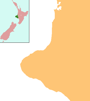
Coordinates: 39°04′S 174°05′E / 39.067°S 174.083°E Country  New Zealand
Region Taranaki Territorial authority New Plymouth District Electorate New Plymouth Government - MP Jonathan Young (National) - Mayor Harry Duynhoven - Deputy Mayor Alex Matheson Area - Territorial 2,324.26 km2 (897.4 sq mi) Population - Territorial 68,901 - Density 29.6/km2 (76.8/sq mi) - Urban 52,200 Time zone NZST (UTC+12) - Summer (DST) NZDT (UTC+13) Area code(s) 06 Website http://www.newplymouthnz.com New Plymouth is the major city of the Taranaki Region on the west coast of the North Island of New Zealand. It is named after Plymouth, Devon, England, from where the first English settlers migrated.
New Plymouth District includes New Plymouth City and several smaller towns. New Plymouth District is the 15th largest district (out of 73) in New Zealand, and has 1.7 percent of New Zealand's population.[1]
New Plymouth District has a population of 68,901 – nearly two thirds of the total population of the Taranaki Region. This includes – New Plymouth City (52,200), Waitara (6,288), Inglewood (3,090), Oakura (1,359), Okato (531) and Urenui (429).[2]
The city is a service centre for the region's principal economic activities including intensive pastoral activities (mainly dairy farming) as well as oil, natural gas and petrochemical exploration and production. It is also the region's financial centre as the home of the TSB Bank (formerly the Taranaki Savings Bank), the largest of the remaining non-government New Zealand-owned banks.
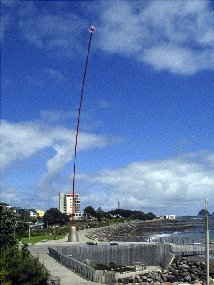
Notable features are the botanic gardens (e.g. Pukekura Park), the 10 km (6.2 mi) Coastal Walkway alongside the Tasman Sea, the Len Lye-designed 45-metre-tall (148 ft) artwork known as the Wind Wand, and views of Mount Taranaki/Egmont.
In 2008, New Plymouth won multiple awards as a city.[citation needed] The city was in 2010 chosen as one of two walking & cycling "Model Communities" by the government. Based on New Plymouth's already positive attitude towards cyclists and pedestrians, the city will receive $3.71m to invest into infrastructure and community programs to boost walking and cycling.[3]
It is also noted for being a coastal city with a mountain within 30 minutes drive, where residents and visitors to New Plymouth can snowboard, ski, water ski and surf all in the same day.
Contents
History
Main article: History of New PlymouthIn 1828 Richard "Dicky" Barrett (1807–47) set up a trading post at Ngamotu after arriving on the trading vessel Adventure. Barrett traded with the local Māori and helped negotiate the purchase of land from them on behalf of the New Zealand Company. Settlers were selected by the Plymouth Company, which was set up to attract emigrants from the West Country of England, and which took over land initially purchased by the New Zealand Company. The first of the town’s settlers arrived on the William Bryan, which anchored off the coast on 31 March 1841. A series of disputes over ownership and settlement of land developed between Māori and settlers soon after and New Plymouth became a fortified garrison town in 1860–1861 as more than 3500 Imperial soldiers, as well as local volunteers and militia, fought Māori in the First Taranaki War.
Growth and governance
New Plymouth Province
The New Zealand Constitution Act 1852 created the New Plymouth Province, with a Provincial Council given jurisdiction over an area of 400,000ha. Five years later the name of the province changed to Taranaki Province. The province was abolished in 1876.
Borough/City of New Plymouth
A Town Board was formed in 1863 and in August 1876 the town was constituted as a borough. Its new status did little to overcome some outside perceptions, however. In 1876 author E. W. Payton wrote that "all the great bustling 'cities' of the colony had a patronising way of trying to snub New Plymouth, referring to it in such derogatory terms as the dullest hole in the colony ... nothing whatever to do there... I find a great liking for this 'slow, old hole' ... it is a quiet, unassuming place and has not done so much to attract immigrants and settlers by exaggerating reports, as some districts have done."[4]
The Fitzroy Town District was merged with New Plymouth borough in August 1911; Vogeltown, Frankleigh Park and Westown were added a year later, followed by St Aubyn-Moturoa. By 1913 the town had a population of 7538. Seafront land was added in 1931 and 1941; land acquired on Omata Rd was added in 1955 and in 1960 large areas including land to the south of Paritutu, as well as Hurdon, Ferndale and Huatoki were included, as well as land straddling Mangorei Rd between the Henui Stream and Waiwakaiho River.
New Plymouth was declared a city in 1949.
New Plymouth District Council
Main article: New Plymouth DistrictIn 1989, as a part of New Zealand-wide reorganisation of local government, New Plymouth City Council was merged with Taranaki County Council, Inglewood Borough Council, Waitara Borough Council, and Clifton County Council to form New Plymouth District Council.
Every three years the Mayor, 14 councillors and 16 community board members are elected by the New Plymouth District’s enrolled voters. The full council, sub-committees and standing committees meet on a six-weekly cycle.
The Policy and Monitoring standing committees have delegated authority from the council to make final decisions on certain matters, and they make recommendations to the council on all others. The four community boards–Clifton, Waitara, Inglewood and Kaitake–as well as the subcommittees and working parties can make recommendations to the standing committees for them to consider.
The third standing committee, the Hearings Commission, is a quasi-judicial body that meets whenever a formal hearing is required–for instance, to hear submissions on a publicly notified resource consent application.
The Chief Executive and approximately 460 full time equivalent staff provide advice and information to the elected members and the public, implement council decisions and manage the district’s day-to-day operations.
This includes everything from maintaining more than 280 parks and reserves, waste water management and issuing consents and permits, through to providing libraries and other recreational services and ensuring the district’s eateries meet health standards.
New Plymouth District Council's annual operating revenue for 2008/2009 is more than $188 million. Visit the NPDC website for more information.[5]
City suburbs
From west to east
- Westown
- Ferndale
- Frankleigh Park
- Vogeltown
- Brooklands
- Welbourn
- East End
- Strandon
- Highlands Park
- Merrilands
- Fitzroy
- Waiwhakaiho
- Glen Avon
Satellite settlements
New Plymouth Airport
Main article: New Plymouth AirportNew Plymouth Airport (IATA: NPL, ICAO: NZNP) serves the city of New Plymouth, and the surrounding region of Taranaki. It is located on the coast, 11 km from the city centre, and 4 km from the outer suburb/satellite town of Bell Block.
It is the 11th busiest airport in New Zealand, with scheduled services to Wellington, Auckland and Christchurch.[6]
Transport and industry
Electric power was first provided in January 1906 from the Mangorei power station alongside the Waiwakaiho River near Burgess Park.[7] In the 1960s, the New Plymouth Power Station was initially designed to run on coal but constructed to be fueled by natural gas or fuel oil. This is a thermal power station with a steam turbine, commenced operation in 1974 with units progressively decommissioned from 2000 with one left operating in 2008.[8]
Companies began searching for oil on the New Plymouth coast in 1865 after small deposits of thick oil were found on the shoreline. The first commercial quantities of oil were obtained in January 1866. Exploration continued sporadically and a refinery opened in 1913. Production ceased about 1972. The offshore Maui A well began production of natural gas in the late 1970s, sparking a flourishing energy and petrochemical industry. As Maui A’s resources decline, new sites in Taranaki are being developed in an effort to find more commercial petrochemical reserves.[9]
An 18 km (11 mi) railway link between New Plymouth and Waitara was completed in 1875; this later became the Waitara Branch. The next year, work began on a line south to Stratford, which was reached in 1879, followed by Hawera in 1881. This line, known as the Marton - New Plymouth Line, was completed on 23 March 1885, and when the Wellington - Manawatu Line of the Wellington and Manawatu Railway Company was opened on 3 November 1886, a direct railway link was established to Wellington.[10] The original routing through the centre of the town was replaced in 1907 by an alignment along the foreshore, which remains today. The New Plymouth Express passenger train began operating on this route in December 1886. In 1926, it was augmented by the Taranaki Flyer for the run between New Plymouth and Wanganui, A direct railway route to Auckland was not established until 1932, when the Stratford - Okahukura Line was completed; the next year, when the line was handed over from the Public Works Department to the New Zealand Railways Department, the New Plymouth Night Express began operating to Auckland.[11] All carriage trains were replaced by RM class Standard and 88 seater railcars by 1956. The Wanganui service ceased in 1959; the Auckland service was truncated to terminate in Taumarunui from 1971; and the Wellington service was cancelled on 30 July 1977. On 11 February 1978, the Taumarunui railcar was replaced by a passenger train, but it was ultimately cancelled on 21 January 1983. Since this date, the only passenger trains to operate to New Plymouth have been infrequent excursions operated by railway preservation societies.[12]
The breakwater at Ngamotu was completed in 1883, providing safe berthage for vessels, and the Moturoa wharf was completed in 1888. Port Taranaki is a critical transport link for the region and the only deep water port on the west coast of New Zealand.
In 1916 the city's electric tramway system began and petrol-powered buses began running four years later. Trams were scrapped in 1954.
The first aircraft landed at the racecourse in 1920 and commercial flights began using the airport at Bell Block in June 1937. During World War II this grass airfield became RNZAF Bell Block; and was replaced in 1966 by the current tarmac airport, 3 km (1.9 mi) NE of the old airport site.
Among the city's major industrial companies was Ivon Watkins-Dow, an agricultural chemicals company founded in 1944 by brothers Ivon, Harry and Dan Watkins and joined as a partner 20 years later by Dow Chemicals of Michigan. The company ran a factory at Paritutu making the herbicide 2,4,5-T. A 2005 study found that people who lived close to the Ivon Watkins-Dow plant between 1962 and 1987 were likely to have dioxin levels on average four times higher than the general public. In some groups the level was as much as seven times as high. A Public Health Medicine senior adviser has claimed that based on international findings, the residents' exposure to dioxin may cause increased rates of disease, in particular cancer. In March 2007 the Ministry of Health announced it would offer a major health support programme to anyone affected.[13][14][15] In April 2008 the Ministry clarified that the programme's main feature would be a free annual medical check up for those who had lived, worked or studied close to the factory.[16]
Features and attractions
New Plymouth District has a reputation as an events centre, with major festivals (the annual TSB Bank Festival of Lights, Taranaki Rhododendron and Garden Festival, WOMAD and the G-TARanaki Guitar Festival, and the biennial Taranaki Arts Festival), sports fixtures (including international rugby, cricket and tennis matches, and the annual ITU World Cup Triathlon) and concerts (from Sir Elton John, Jack Johnson, Westlife, R.E.M and Fleetwood Mac).
With its rich volcanic soil, the city is well known for its gardens. Chief among them are the 52 ha Pukekura Park in the centre of the city (named a Garden of National Significance), and Pukeiti, a rhododendron garden of international significance high on the Pouakai Range.
Pukekura Park is also the home of the TSB Bank Festival of Lights, which runs for free every year from mid-December to early February. It has daytime and night time programmes of events for people of all ages, and the festival itself transforms the park into an illuminated wonderland every evening.
Next to the foreshore in the central city is Puke Ariki – the world’s first purpose-built, fully integrated museum, library and information centre which tells the stories of Taranaki in a variety of interactive media.
Nearby is the Govett-Brewster Art Gallery, a contemporary art museum and the home of the collection of film maker and kinetic artist Len Lye. Plans are in place to house Lye's collection in a purpose-built centre next to the gallery, making New Plymouth the world centre for Len Lye.
 Te Rewa Rewa Bridge which immediately became a symbol of the extensive cycling opportunities that have been created in and around New Plymouth.
The Coastal Walkway is a 7 km path that forms an expansive sea-edge promenade stretching almost the entire length of the city, from the Bell Block mouth in the east to Port Taranaki in the west. The pathway includes the iconic Te Rewa Rewa Bridge and is ideal for walking, running, cycling or skating, or simply enjoying the view of the dramatic west coast.[17] It has won numerous awards, including the Cycle Friendly Award in 2008 for the best New Zealand cycle facility.
Right next to the Coastal Walkway is the Todd Energy Aquatic Centre, with indoor and outdoor pools, a diving pool, wave machine, hydroslides, spa, sauna and gym.
Mount Taranaki/Egmont provides recreation opportunities, from skiing and snowboarding to rock climbing and alpine walks. The North Egmont Visitors Centre is 20 minutes' drive from central New Plymouth.
Taranaki is known as big wave territory with some of the country's best surfing spots found off this coastline.
The region has 20 golf courses, ranging from nine-hole country courses where you have to move the sheep, through to Ngamotu Links–consistently rated one of the best golf courses in New Zealand. All 20 golf courses are within an hour’s drive of each other.
Centre City Shopping Centre is the only mall in New Plymouth. It contains over 55 shops and services.
Awards
New Plymouth won the Top Town award from North and South Magazine in 2008 (judged "the best place in New Zealand to live, love, work and raise a family").[18]
The city also won three awards at the 11th International Awards for Liveable Communities held in Dongguan, China, 6–10 November 2008:[19]
- Whole City Gold award (population category 20,000 – 75,000)
- Criteria award for Community Sustainability
- Gold award for community project (natural) – the Coastal Walkway.[20]
Climate
New Plymouth has a warm, moist, temperate climate. The average summer afternoon temperature is 21–22 °C (70–72 °F); average summer night-time temperature is 12–13 °C (54–55 °F). In winter the average afternoon temperature is 13–14 °C (55–57 °F) and night-time temperature is 5–6 °C (41–43 °F). The average annual rainfall is 1,432 mm (56.4 in). On 15 August 2011 it snowed in New Plymouth which is such a rare event that it has been described as a once in a generation occurrence.
Climate data for New Plymouth Month Jan Feb Mar Apr May Jun Jul Aug Sep Oct Nov Dec Year Average high °C (°F) 21.8
(71.2)22.3
(72.1)21.1
(70.0)18.7
(65.7)16
(61)14
(57)13.3
(55.9)13.9
(57.0)15
(59)16.3
(61.3)18.1
(64.6)19.9
(67.8)17.5 Average low °C (°F) 13.6
(56.5)13.6
(56.5)12.7
(54.9)10.6
(51.1)8.3
(46.9)6.6
(43.9)5.6
(42.1)6.4
(43.5)7.9
(46.2)9.2
(48.6)10.8
(51.4)12.3
(54.1)9.8 Precipitation mm (inches) 97
(3.82)95
(3.74)117
(4.61)131
(5.16)124
(4.88)145
(5.71)143
(5.63)127
(5)110
(4.33)124
(4.88)108
(4.25)103
(4.06)1,432
(56.38)Source: NIWA Climate Data[21] Sister cities
Education
Main article: List of schools in the Taranaki Region#New Plymouth DistrictThere are three schools within the central city, and suburban schools in Fitzroy, Frankleigh Park, Lynmouth, Mangorei, Marfell, Merrilands, Moturoa, Spotswood, Vogeltown, Welbourn and Westown. The Western Institute of Technology at Taranaki has its main campus in central New Plymouth.[22]
In the inner city, New Plymouth Boys' High School and New Plymouth Girls' High School are single-sex secondary (years 9–13) schools with rolls of 1219[23] and 1218[24] respectively. The Boys' School was founded in 1882.[25] The decile ratings of the two schools are 8 and 7, respectively.
Central School is a coeducational contributing primary (years 1–6) schools with a roll of 212 and a decile rating of 8.[26] Central School opened in 1884.[27]
References
- ^ Quickstats about New Plymouth District
- ^ Statistics New Zealand Census 2006
- ^ "Big bucks for bike paths". Taranaki Daily News. 28 June 2010. http://www.stuff.co.nz/taranaki-daily-news/news/3857083/Big-bucks-for-bike-paths. Retrieved 11 November 2010.
- ^ As quoted by J.S. Tullett, who cites "Early Days, Taranaki" by F. B. Butler (1942).
- ^ New Plymouth District Council website.
- ^ NPDC
- ^ Puke Ariki essay on electricity generation in Taranaki
- ^ "information sheet on New Zealand power stations". Contact Energy. http://www.contactenergy.co.nz/web/view?page=/contentiw/pages/shared/powerstations&vert=au.
- ^ "About New Plymouth". New Plymouth District Council. http://www.newplymouthnz.com/LivinginNewPlymouth/AboutNewPlymouth/.
- ^ New Zealand Railway and Tramway Atlas, fourth edition, edited by John Yonge (Essex: Quail Map Company, 1993), 9–11, 15.
- ^ J. D. Mahoney, Kings of the Iron Road: Steam Passenger Trains of New Zealand (Palmerston North: Dunmore Press, 1982), 67, 71.
- ^ Geoffrey B. Churchman and Tony Hurst, The Railways of New Zealand: A Journey Through History (Auckland: HarperCollins, 1991), 132–3, 140–1.
- ^ "Health support for Taranaki residents exposed to dioxin". New Zealand Herald. 27 March 2007. http://www.nzherald.co.nz/location/story.cfm?l_id=146&objectid=10431141.
- ^ "The Poisoning of New Zealand". Investigate magazine. http://www.investigatemagazine.com/poisoning_of_new_zealand%20OCT2000.htm.
- ^ O'Connor, Damien (3 April 2003). "Search on for former Paritutu residents". http://www.beehive.govt.nz/ViewDocument.aspx?DocumentID=16411.
- ^ "Health support service for people exposed to dioxin". Ministry of Health. 29 April 2008. http://www.moh.govt.nz/moh.nsf/indexmh/dioxins-healthsupportprogramme#news.
- ^ "Coastal Walkway". NPDC. http://www.newplymouthnz.com/VisitingNewPlymouth/Attractions/CoastalWalkway.htm. Retrieved 2 January 2010.
- ^ "New Plymouth Named New Zealand’s Top City". Scoop.co.nz. http://www.scoop.co.nz/stories/AK0810/S00133.htm.
- ^ Livcom coverage
- ^ Livcom awards website
- ^ "Climate Data". NIWA. http://www.niwascience.co.nz/edu/resources/climate/. Retrieved 2 November 2007.
- ^ "WITT HISTORY". Western Institute of Technology. http://www.witt.ac.nz/Content/100012417.aspx.
- ^ "Te Kete Ipurangi – New Plymouth Boys' High School". Ministry of Education. http://www.tki.org.nz/e/schools/display_school_info.php?school_id=171.
- ^ "Te Kete Ipurangi – New Plymouth Girls' High School". Ministry of Education. http://www.tki.org.nz/e/schools/display_school_info.php?school_id=172.
- ^ "Jubilees & reunions: New Plymouth Boys' High School 125th Jubilee" (–Scholar search). Education Gazette New Zealand 85 (13). 7 August 2006. http://www.edgazette.govt.nz/notices.php?action=view&id=604005.[dead link]
- ^ "Te Kete Ipurangi – Central School, New Plymouth|Central School". Ministry of Education. http://www.tki.org.nz/e/schools/display_school_info.php?school_id=2160.
- ^ "New Plymouth Central School (B213)". National Register of Archives and Manuscripts. http://www.nram.govt.nz/record.php?holderid=73&id=6895&parent=ncindex.
External links
Categories:- Taranaki Region
- New Plymouth District
- Populated places in New Zealand
- Port cities in New Zealand
- Populated places established in 1841
- Surfing locations in New Zealand

Wikimedia Foundation. 2010.