- Daman, Daman and Diu
-
Daman — capital — Coordinates 20°25′N 72°51′E / 20.42°N 72.85°ECoordinates: 20°25′N 72°51′E / 20.42°N 72.85°E Country India Territory Daman and Diu District(s) Daman Population 35,743 (2001[update]) Time zone IST (UTC+05:30) Area
• 5 metres (16 ft)
Daman (Damão in Portuguese), is a city and a municipal council in Daman district in the union territory of Daman & Diu, India. Although there is no public airport in the area, the Indian Coast Guard operates the small Daman Airport which is sometimes used by public companies (mostly state run airlines operate some aircraft from there).

Contents
Geography
Daman has an average elevation of 5 metres (16 ft).
Daman city
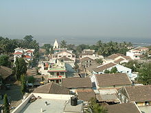
Daman is divided by the Daman Ganga River into two parts namely Nanidaman (Nani meaning "small") and Motidaman (Moti meaning "big"). Ironically, Nanidaman is the larger of the two towns. It is the downtown area containing most of the important entities like the major hospitals, supermarkets, major residential areas etc. While Motidaman is mainly the old city inhabited mostly by the fishing communities and government officers (most of the public offices are located there). Both Nanidaman and Motidaman are connected to each other by two bridges (one for light vehicles like two-wheelers and the other for heavy vehicles like trucks, cars etc.). The smaller bridge collapsed in August, 2004 killing 28 school children. It was replaced but that bridge also collapsed. Since then it has not been rebuilt. Small boats ferry people from one side to the other several times a day for INR 2. New bridge has been constructed that connects two parts of daman i.e. Nani Daman and Moti Daman. Daman was discovered in 1523 by Diogo-de-Melo, who was heading towards Ormuz but was caught in a violent storm and his boat was blown towards the coast of Daman.[1] Soon after it was settled as a Portuguese colony and remained so for over 400 years. A larger fort was built in Motidaman in the 16th century to guard against the Mughals who ruled the area until the Portuguese arrived. It still stands today, most of it preserved in its original form. Today the majority of the municipal government offices are situated inside this fort. Daman was incorporated into the Republic of India in 1961 after a battle between the Portuguese and the Indians. The battle left 4 Indians dead and 14 wounded,[2] and 10 Portuguese dead and 2 wounded.[3] Located 93 kilometres (58 mi) north of Mumbai, Daman, along with neighboring Vapi, Bilimora and Silvassa form an important manufacturing hub. A variety of products like pesticides, chemicals, fertilizers, toys, electronics, dyes, printing ink, windmills, plastics, etc. are manufactured here. People enjoy a modest quality of life here as Daman has a number of reputed hospitals, schools and other public institutions. Educated and well qualified people from all over India migrate here in search of work. Daman is well-connected to other parts of India primarily though NH-8. The neighboring city Vapi (located 12 kilometres (7.5 mi) from Daman) is connected to the Indian rail network.
Daman villages
There are many small villages around Daman, such as Benslore, Kunta,bhimpor,kadya, Varkund and Khariwar. These villages mainly act as residential areas for lower-middle class families. Here Varkund is the biggest village in Daman,in which a big meghastructure is been built it called Thunderbird resort,it has the 4th licence of casino in India
Demographics
As of 2001[update] India census,[4] Daman had a population of 35,743. Males constitute 53% of the population and females 47%. Daman has an average literacy rate of 76%, higher than the national average of 64.84%: male literacy is 81% and female literacy is 70%. In Daman, 12% of the population is under 6 years of age.
Most of the population in Daman consists of skilled and educated migrant workers (from all over India) who reside in Daman for a period of around 4 to 5 years. The local population consists of mostly fishermen called Tandels in Gujarati. The major part of the population is a mixture of Hindus, Muslims and Christians, with Hindus being dominant in number. There has never been any communal violence reported in this area.
Tourism
 Daman Port
Daman is a popular tourist destination. This is mainly due to its relatively untouched beaches and freedom to drink liquor, which is prohibited in the neighboring state of Gujarat. It mainly attracts tourists from neighboring areas like Vapi, Valsad, Surat and even Baroda. The two well-known beaches of Daman are Devka beach and Jumpore beach.
Pollution
Daman along with Vapi is one of the world's most polluted areas. As of 2007, the Blacksmith Institute, Germany rated this area as the fifth most polluted place in the world. Major pollutants include heavy metals like lead, cadmium, etc. There are lot of pharmaceutical industries in Vapi that causes major concern for pollution.
References
- ^ Singh, Kumar Suresh (1995). Daman and Diu. People of India. XIX. Popular Prakashan. p. 3. http://books.google.com.br/books?id=KRhkT8SjhD8C&pg=PA3&dq=Daman%2BVasco+de+Gama%2B1523&hl=pt-br&ei=fxYMTYXaNoO0lQfjgZ2HDA&sa=X&oi=book_result&ct=result&resnum=1&ved=0CCwQ6AEwAA#v=onepage&q=Daman%2BVasco%20de%20Gama%2B1523&f=false. Retrieved 2010-12-18.
- ^ Anil Shorey (21 February 1999). "The Forgotten Battles of Daman and Diu". The Tribune. http://www.tribuneindia.com/1999/99feb21/sunday/head3.htm. Retrieved 18 December 2010.
- ^ Chakravorty, Dr. B.C. (2008). "Operation Vijay". Bharat Rakshak. Retrieved 12/18/2010.
- ^ "Census of India 2001: Data from the 2001 Census, including cities, villages and towns (Provisional)". Census Commission of India. Archived from the original on 2004-06-16. http://web.archive.org/web/20040616075334/http://www.censusindia.net/results/town.php?stad=A&state5=999. Retrieved 2008-11-01.
External links
- Administration of Daman and Diu: Official Website
- Daman Tourism Website
 State and Union Territory capitals of India
Agartala · Aizawl · Bangalore · Bhopal · Bhubaneswar · Chandigarh · Chennai (Madras) · Daman · Dehradun · New Delhi · Dispur · Gandhinagar · Gangtok · Hyderabad · Imphal · Itanagar · Jaipur · Jammu (in winter) · Kavaratti · Kohima · Kolkata (Calcutta) · Lucknow · Mumbai (Bombay) · Panaji (Panjim) · Patna · Puducherry (Pondicherry) · Port Blair · Raipur · Ranchi · Shillong · Shimla · Silvassa · Srinagar (in summer) · Thiruvananthapuram (Trivandrum)
Categories:- Indian capital cities
- Daman, India
- Cities and towns in Daman district


Wikimedia Foundation. 2010.