- Danakil Depression
-
See also: Eritrean coastal desert
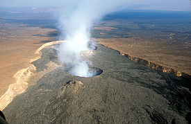 Erta Ale shield volcano in the Danakil Desert
The Danakil Depression is a desert basin which lies in the Danakil Desert in north-eastern Ethiopia and southern Eritrea. It belongs to the homeland of the Afar people. It lies up to 100 m below sea level as a result of tectonic activity caused by plate movements. The presence of many volcanoes in the region, including Erta Ale and the Dabbahu Volcano in the middle of the depression, also finds its cause in these plate movements.It was named by National Geographic as the "Cruelest Place on Earth".
World deserts Africa Asia - Ad-Dahna
- Arabian
- Aral Karakum
- Aralkum
- Badain Jaran
- Betpak-Dala
- Cholistan
- Dasht-e Kavir
- Dasht-e Lut
- Dasht-e Margoh
- Dasht-e Naomid
- Gurbantünggüt
- Gobi
- Hami
- Indus Valley
- Judean
- Karakum
- Kharan
- Kumtag
- Kyzyl Kum
- Lop
- Nefud
- Negev
- Ordos
- Qaidam
- Rub' al Khali
- Russian Arctic
- Registan
- Saryesik-Atyrau
- Syrian
- Taklamakan
- Tengger
- Thal
- Thar
- Tihamah
- Ustyurt Plateau
- Wahiba Sands
- Liwa
Europe North America - Alvord
- Amargosa
- Baja California
- Black Rock
- Carcross
- Channeled scablands
- Chihuahuan
- Escalante
- Forty Mile
- Gran Desierto de Altar
- Great Basin
- Great Salt Lake
- Great Sandy
- Jornada del Muerto
- Kaʻū
- Lechuguilla
- Mojave
- North American Arctic
- Owyhee
- Painted Desert
- Red Desert
- Sevier
- Smoke Creek
- Sonoran
- Tule (Arizona)
- Tule (Nevada)
- Yp
- Yuha
- Yuma
Australia South America Polar regions New Zealand Categories:- Afar Region
- Deserts of Ethiopia
- Deserts of Eritrea
- Afar geography stubs
- Eritrea geography stubs

Wikimedia Foundation. 2010.