- Dão-Lafões Subregion
-
 Dão-Lafões
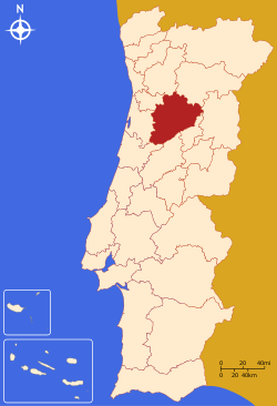
Dão-Lafões is a Portuguese NUTS III sub-region in the Centro Region. It is located in central Portugal, and has an approximate area of 3,483 km² and 286,315 inhabitants. Its largest city is Viseu (with approx. 50,000 inhabitants).
Municipalities
- Aguiar da Beira
- Carregal do Sal
- Castro Daire
- Mangualde
- Mortágua
- Nelas
- Oliveira de Frades
- Penalva do Castelo
- Santa Comba Dão
- São Pedro do Sul
- Sátão
- Tondela
- Vila Nova de Paiva
- Viseu
- Vouzela
All the above municipalities are either towns or city, and lie in Viseu District, except for Aguiar, which is part of Guarda District.
 NUTS 2 regions, NUTS 3 subregions and Districts of Portugal
Norte Region Subregions: Alto Trás-os-Montes · Ave · Cávado · Douro · Entre Douro e Vouga · Grande Porto · Minho-Lima · Tâmega · Districts: Braga · Bragança · Porto · Viana do Castelo · Vila Real · Aveiro * · Guarda * · Viseu *Centro Region Subregions: Baixo Mondego · Baixo Vouga · Beira Interior Norte · Beira Interior Sul · Cova da Beira · Dão-Lafões · Médio Tejo · Oeste · Pinhal Interior Norte · Pinhal Interior Sul · Pinhal Litoral · Serra da Estrela · Districts: Castelo Branco · Coimbra · Leiria · Aveiro * · Guarda* · Santarém * · Viseu *Lisboa Region Alentejo Region Algarve Region Subregions: Algarve · Districts: FaroAzores Subregions: AzoresMadeira Subregions: Madeira(*) Situated in more than one Region. NOTE: The Azores and Madeira are Autonomous Regions: districts have been discontinued in these areas and local government replaced by LAU1 and LAU2 authorityCategories:- NUTS 3 Statistical Regions of Portugal

Wikimedia Foundation. 2010.