- Roxbury, Boston
-
Roxbury — Neighborhood of Boston — First Church of Roxbury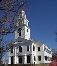

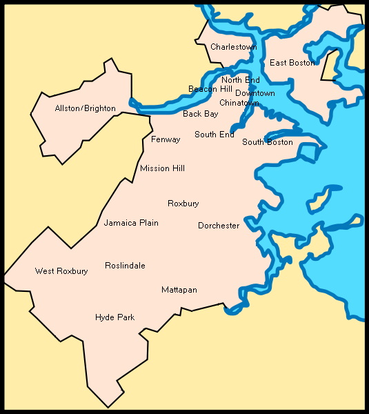
SealSettled 1630 Incorporated 1846 Annexed by Boston 1868 Time zone Eastern – Summer (DST) Eastern (UTC) Area code(s) 617 / 857 Roxbury is a dissolved municipality and current neighborhood of Boston, Massachusetts, United States.[1] It was one of the first towns founded in the Massachusetts Bay Colony in 1630, and became a city in 1846 until annexed to Boston on January 5, 1868.[2] The original town of Roxbury once included the current Boston neighborhoods of Jamaica Plain, Roslindale, West Roxbury, the South End and much of Back Bay. Roxbury now generally ends at Hammond St, Davenport St to the east and East Lenox St/Melnea Cass Blvd to the south.
Roxbury is now one of 21 official neighborhoods of Boston, used by the city for neighborhood services coordination. The city asserts that it "serves as the heart of Black culture in Boston."[3]
The original boundaries of the Town of Roxbury can be found in Drake's History of Roxbury and its noted Personages. Those boundaries include the Christian Science Center, the Prudential Center (built on the old Roxbury Railroad Yards) and everything south and east of the Muddy River including Symphony Hall, Northeastern University, Y.M.C.A., Harvard Medical School and many hospitals and schools in the area. This side of the Muddy River is Roxbury, the other side is Brookline and Boston. Franklin Park, once entirely within Roxbury when Jamaica Plain, West Roxbury and Roslindale were villages within the town of Roxbury until 1854, has been divided with the line between Jamaica Plain and Roxbury located in the vicinity of Peter Parley Road on Walnut Avenue, through the park to Columbia Road. Here, Walnut Avenue changes its name to Sigourney Street, indicating the area is now Jamaica Plain. One side of Columbia Road is Roxbury, the other Dorchester. Melnea Cass Boulevard is locate approximately over the Roxbury Canal that brought boats into Roxbury, bypassing the busy port of Boston in the 1830s.
A store known as The Blue Store was located at the intersection of Washington and Warren streets in Dudley since 1699.[citation needed] Many remember the furniture store there known as Ferdinand's Blue Store, as the elevated train bisected the building. This area was also the home to several famous Boston business firms, W. Bowman Cutter's Hardware Store with the upside down sign, Timothy Smith's Department Store, and J. S. Waterman and Sons, funeral directors to many prominent Boston families.
Contents
History
Early history
 Munroe House in 1905, built in 1683
Early settlers of the Massachusetts Bay Colony established a series of six villages in 1630.[2] The village of Roxbury (originally called “Rocksberry”[2] for the rocks in its soil that made early farming a challenge,) has long been noted for its hilly geography and many large outcroppings of Roxbury puddingstone, which was quarried for many years and used in the foundations of a large number of houses in the area.
The town is located where Boston was previously connected to mainland Massachusetts by a narrow isthmus called Boston Neck or alternately, Roxbury Neck. (Boston has since land-filled around the area so that Boston is no longer located on an isthmus.) Since all initial land traffic to Boston had to pass through Roxbury, it became an important town. Originally, it would be home to a number of early leaders of the colony, including original Massachusetts Bay Colony treasurer William Pynchon, who left Roxbury in 1636 with nearly one third its men to found Springfield, Massachusetts on far less rocky and more arable soil. [4] Later, Roxbury would be home to colonial governors Thomas Dudley, William Shirley, Increase Sumner. The Shirley-Eustis House, built at Roxbury during the period 1747–1751, is one of only four remaining Royal Colonial Governors' mansions in the United States.
 Roxbury Town Hall in 1899, built in 1810
The settlers of Roxbury originally comprised the congregation of the First Church of Roxbury, established in 1632.[5] During this time the church served not only as a place of worship but as a meeting place for government. The congregation had no time to raise a meeting house the first winter and so met with the neighboring congregation in Dorchester. One of the early leaders of this church was Amos Adams, and among the founders were Richard Dummer and his wife Mary.[6] The first meeting house was built in 1632, and the building pictured here is the fifth meeting house, the oldest such wood-frame church in Boston.[7] The Roxbury congregation, still in existence as a member congregation of the Unitarian Universalist Association, lays claim to the historical founding - along with five other local congregations, i.e. Boston, Cambridge, Watertown, Charlestown and Dorchester - of Harvard College. Also, the First Church of Roxbury was the starting point for William Dawes' "Midnight Ride", April 18, 1775 (in a different direction than Paul Revere) to warn Lexington and Concord of the British raids during the Revolutionary War.
Urban and industrial development
 Fort Hill Tower (also the Cochituate Standpipe), designed by Nathaniel J. Bradlee and built in 1869 on the site of Revolutionary War fortifications
As Roxbury developed in the 19th century, the northern part became an industrial town with a large community of English, Irish, and German immigrants and their descendants, while the majority of the town remained agricultural and saw the development of some of the first streetcar suburbs in the United States. This led to the incorporation of the old Roxbury village as one of Massachusetts's first cities, and the rest of the town was established as the town of West Roxbury.
In the early 20th century, Roxbury became home to recent immigrants - A thriving Jewish community developed around Grove Hall, along Blue Hill Avenue, Seaver Street and into Dorchester along Columbia Road. A large Irish population also developed, with many activities centered around Dudley Square, which just before and following annexation into Boston, became a central location for Roxbury commerce. Following a massive migration from the South to northern cities in the 1940s and 1950s, Roxbury became the center of the African-American community in Boston. The center of African American residential and social activities in Boston had formerly been on the north slope of Beacon Hill and the South End. In particular, a riot in response to the assassination of Martin Luther King Jr. resulted in stores on Blue Hill Avenue being looted and eventually burned down, leaving a desolate and abandoned landscape which discouraged commerce and business development. Rampant arson in the 1970s along the Dudley Street corridor also added to the neighborhood's decline, leaving a landscape of vacant, trash filled lots and burned out buildings. The arrival of the crack epidemic in the 1980s helped make Roxbury one of the most dangerous neighborhoods in Boston. The violent crime would not be significantly reduced until the late 1990s. In early April 1987, the original Orange Line MBTA route along Washington Street was closed and relocated to the Southwest Corridor (where the Southwest Expressway was supposed to be built a couple decades before). More recently, grassroots efforts by residents have been the force behind revitalizing historic areas and creating Roxbury Heritage State Park, although an effort by some to secede from Boston and form an independent municipality named "Mandela" (after South African activist Nelson Mandela) failed in 1986.[citation needed]
The Boston Transportation Planning Review stimulated relocation of the Orange Line, and development of the Southwest Corridor Park spurred major investment, including Roxbury Community College at Roxbury Crossing and Ruggles Center at Columbus Avenue and Ruggles Street. Commercial development now promises reinvestment in the form of shopping and related consumer services. The Fort Hill section experienced significant gentrification when college students (many from Northeastern University and Wentworth Institute of Technology), artists, and young professionals moved into the area in the late 1990s and early 2000s. In the present day, there is much commercial and residential redevelopment.
Demographics
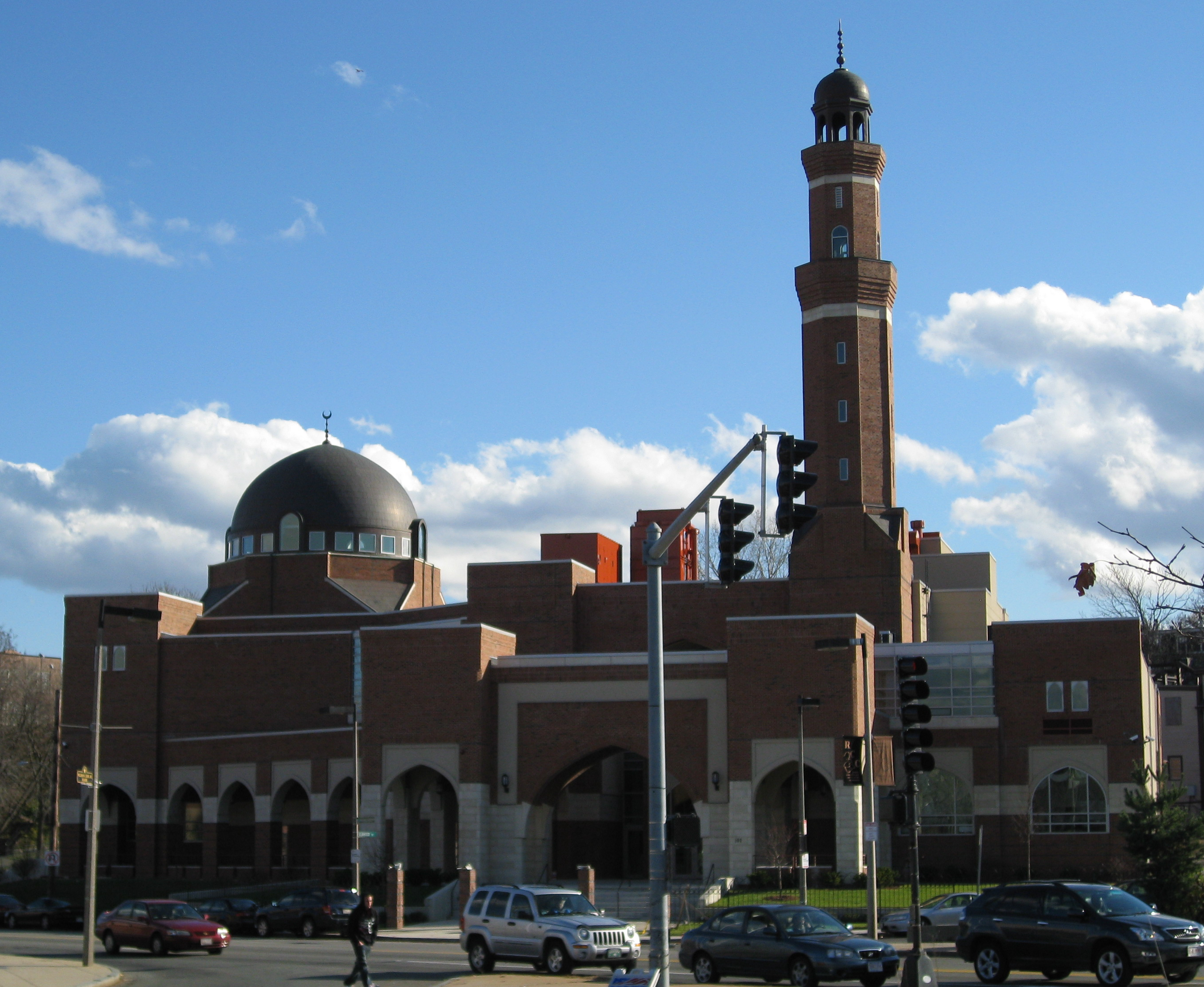
 The First Mosque of Roxbury, the Islamic Society of Boston
Roxbury is still a majority African-American neighborhood as it has been since 1960, but there is a growing Puerto Rican population. In 1987, Nelson Merced, a Puerto Rican, was elected from the fifth Suffolk district in Boston. As of the 2010 census Roxbury was 20.6% Non-Hispanic White, 42.5% Non-Hispanic African-American or Black, 25.6% Hispanic or Latino, who can be of any race, 5.6% Asian-American, 2.5% from other races and 3% from two or more races.[8]
Education
Primary and secondary schools
Students in Roxbury are served by Boston Public Schools (BPS). BPS assigns students based on preferences of the applicants and priorities of students in various zones.[9]
Roxbury Preparatory Charter School is a public charter school that serves Grades 6-8 in the Roxbury neighborhood of Mission Hill.
Roxbury High School was once located on Greenville Avenue.[10]
Colleges and universities
Roxbury is home to Roxbury Community College, and to Gordon-Conwell Theological Seminary's Center for Urban Ministerial Education (CUME). Further, The Eastern Nazarene College offers Adult Studies/LEAD classes in Roxbury.[11]
Public libraries
Boston Public Library operates the Dudley Branch Library in Roxbury. The branch, which opened in April 1978, replaced the Mount Pleasant Branch, a library branch, and the Fellowes Athenaeum, a privately endowed facility.Next to the Dudley Branch Library is the Dudley Literacy Center which assists patrons who are learning English as a second language. It is the largest public library literacy center in the Boston Public Library system. The Grove Hall Branch of the Boston Public Library, which was formerly located on Crawford Street since 1971, is now located at 41 Geneva Avenue in Dorchester/Roxbury. The Branch is in a new facility that opened in April, 2009.[12]
Notable residents
- Irving Ashby (1920–1987) jazz guitarist
- Ruth Batson (1921–2003), civil rights and education activist
- Susan Batson, actress, daughter of Ruth Batson
- Ricky Bell, Member of R&B group New Edition formed in Boston in 1978
- Michael Bivins, Member of R&B group New Edition formed in Boston in 1978
- Nathaniel Jeremiah Bradlee (1829–1888), architect
- Edward Brooke, U.S. senator, first African American elected to Senate in the 20th century
- Bobby Brown, Member of R&B group New Edition formed in Boston in 1978
- Henry Dearborn (1751–1829), physician, general, U.S. representative, U.S. Secretary of War
- Henry Alexander Scammell Dearborn (1783–1851), U.S. representative, mayor of Roxbury, son of Henry Dearborn.
- Ronnie DeVoe, Member of R&B group New Edition formed in Boston in 1978
- Joseph Dudley (1647–1720), colonial governor of Massachusetts, son of Thomas Dudley
- Thomas Dudley (1576–1653), colonial governor of Massachusetts
- Ed O.G., hip hop artist, founder of Da Bulldogs, named an album after Roxbury.
- John Eliot (1604–1690), minister, Bible translator, founder of Roxbury Latin School
- Gustavus Esselen (1888–1952), chemist, born in Roxbury
- William Eustis (1753–1825), governor of Massachusetts, owner of Shirley-Eustis House in Roxbury
- Louis Farrakhan, Nation of Islam leader, activist,[13] raised in Roxbury
- Mark Frechette (1947–1975), film actor, Zabriskie Point
- The G-Clefs, Top 40 Soul Group
- William Lloyd Garrison (1805–1879), journalist, abolitionist, lived in Roxbury the last 15 years of his life[14]
- Charles Dana Gibson (1867–1944), illustrator
- Samuel Griswold Goodrich (1793–1860), author, state legislator
- Guru (1961–2010), rapper, member/founder of Gang Starr
- Edward Everett Hale (1822–1909), author, reformer, Unitarian clergyman
- Roy Haynes (born 1925), jazz drummer and bandleader
- Elma Lewis (1921–2004), arts educator, founder of the National Center of Afro-American Artists (NCAAA)
- Mel Lyman (1938–1978), harmonica player, cult leader
- Nelson Merced, state legislator, Latino activist
- Members of New Edition, R&B / Pop group
- Patrice Oneal, comedian, actor.
- Louis Prang (1824–1909), printer, lithographer and publisher
- William Pynchon (1590–1662), founder of Roxbury and Springfield, Massachusetts
- Sylvester H. Roper (1823–1896), inventor
- Nathaniel Ruggles (1761–1819), U.S. representative.
- Byron Rushing, state legislator, activist
- Kenneth Kamal Scott, singer, dancer, actor, nephew of Irving Ashby.
- Ebenezer Seaver (1763–1844), U.S. representative.
- William Shirley (1694–1771), colonial governor of Massachusetts, built Shirley-Eustis House in Roxbury
- Aafia Siddiqui, neuroscientist, alleged Al-Qaeda operative, Roxbury resident 1995-2001
- Ebenezer Stevens (1751–1823), American Revolution activist, officer
- Sonny Stitt (1924–1982), jazz saxophonist
- John L. Sullivan (1858–1918), boxing heavyweight champion, born in Roxbury[15]
- Donna Summer, R&B Star, "Queen of Disco"[16]
- Increase Sumner (1746–1799), governor of Massachusetts
- Ralph Tresvant, Member of R&B group New Edition formed in Boston in 1978
- Jimmy Walker (1944–2007), professional basketball guard
- Joseph Warren (1741–1775), physician, Revolutionary major general
- "Masspike Miles" Wheeler (born 1980), R&B artist, member of Perfect Gentlemen.[17]
- Tony Williams (1945–1997), jazz drummer, grew up in Roxbury
- Malcolm X (1925–1965), Nation of Islam minister and activist,[18] spent formative years in Roxbury.
Sites of interest
- Franklin Park Zoo
- Shirley-Eustis House
- John D. O'Bryant School of Mathematics & Science
- Roxbury Historic Markers
See also
- Dudley Square
- Roxbury Film Festival
- St. Joseph's Church
- West Roxbury
- Former Mayors of Roxbury
- Roxbury High Fort
- Boston Latin Academy
References
- ^ "Boston's Neighborhoods: Roxbury". Boston Redevelopment Authority (BRA). 2010. http://www.bostonredevelopmentauthority.org/neighborhoods/neighborhoods.asp?action=ViewHood&HoodID=16. Retrieved August 17, 2010.
- ^ a b Roxbury History. Part of Roxbury had become the town of West Roxbury on May 24, 1851, and additional land in Roxbury was annexed by Boston in 1860.
- ^ "Roxbury." City of Boston. Retrieved on May 2, 2009.
- ^ http://www.archive.org/stream/kingshandbookofs00kring#page/10/mode/2up
- ^ First Church in Roxbury, MA. Records, 1641-1956, Harvard University Library
- ^ Thwing, Walter Eliot (1908). "First Church in Roxbury (1630–1650)". http://newpennacook.blogspot.com/2007/11/first-church-of-roxbury-1630-1650.html. Retrieved 28 June 2010.
- ^ Historical Markers: Roxbury The Boston Historical Society
- ^ http://www.boston.com/yourtown/boston/roxbury/news/census_2010/
- ^ "Student Assignment Policy." Boston Public Schools. Retrieved on April 15, 2009.
- ^ "Roxbury High School students." The Ten O'Clock News at Open Vault WGBH-TV. September 13, 1978. Retrieved on April 16, 2009.
- ^ "ENC's Adult and Graduate Studies Program expands into satellite locations around the state". Nazarene Communications Network. December 18, 2008. http://www.ncnnews.com/nphweb/html/ncn/article.jsp?sid=10000013&id=10006683.
- ^ "Dudley Branch Library." Boston Public Library. Retrieved on May 23, 2010.
- ^ Fineman, Howard and Vern E. Smith. "Article: An angry 'charmer.' (Louis Farrakhan)(includes related article)(Cover Story)." Newsweek. October 30, 1995. Retrieved on June 18, 2009.
- ^ [1] The William Lloyd Garrison House
- ^ "Founding father of the sweet science." The Irish Times. Wednesday October 29, 2008. Retrieved on June 18, 2009.
- ^ Morse, Steve. "A WARM HOMECOMING FOR DONNA SUMMER." The Boston Globe. July 24, 1990. Retrieved on June 18, 2009.
- ^ Reid, Shaheem, "Kanye West 'Inspired' By Lady Gaga's 'Poker Face' For Kid Cudi Single; Plus: Masspike Miles gets a boost from Rick Ross, in Mixtape Daily", MTV News, May 28, 2009
- ^ Helfer, Andrew; Randy DuBurke (2006). Malcolm X: A Graphic Biography. New York: Hill and Wang. p. 40. ISBN 0-8090-9504-1.
Further reading
- Roxbury Directory. Roxbury: John Backup. 1858; 1866.
- "Historical Sketch of Boston Highlands", Mercantile Publishing Company, Boston, 1888. There is much information on Roxbury.
- City of Boston & Boston Redevelopment Authority, "Roxbury Strategic Master Plan", 2004
- Sammarco, Anthony Mitchell; Rosenberg, Charlie, Roxbury, Arcadia Publishing, Then & Now series, 2007
- Roxbury History—Boston Landmarks Commission (2007 archived version)
- Born before plastic: stories from Boston's most enduring neighborhoods; North End, Roxbury, and South Boston, Boston, Massachusetts, USA: City of Boston and Grub Street, Inc., 2007, http://openlibrary.org/books/OL24643200M/Born_before_plastic_stories_from_Boston's_most_enduring_neighborhoods
External links
- 1832 Map of the Town of Roxbury - Jamaica Plain Historical Society
- 1832 Map of Roxbury by John G. Hales at the BPL.
- 1849 Map of Roxbury by Charles Whitney at the BPL.
- 1868 Map of Roxbury and Boston by E.P.Dutton at the BPL.
- 1895 Outline and Ward Index Map of Boston and Roxbury by George and Walter Bromley.
- 1895 Map of Ward 17 Roxbury area of Hampton, Gerand, Allerton, and Mass. Ave showing New England Piano, Mechanics Foundry, and Boston Lead Works at DavidRumsey.com .
- 1895 Atlas of Boston and Roxbury links to the Roxbury Plates - 19, 20, 21, and 31-45.
- Bailey Co. Map—1888 bird's-eye view map of Roxbury area
- Vital Records Of Roxbury 1765-1870 population
- Discover Roxbury—tours and information
- Shirley-Eustis House—Massachusetts' Royal Governor's Mansion
- Roxbury Crossing Historical Trust—historical society
- Roxbury Neighborhood - Boston Revelopment Authority
- The La Alianza Hispana records, 1960-1999 (bulk 1975-1995) are located in the Northeastern University Libraries, Archives and Special Collections Department, Boston, MA.
- The Lower Roxbury Community Corporation records, 1968-1978 are located in the Northeastern University Libraries, Archives and Special Collections Department, Boston, MA.
- The Roxbury Multi-Service Center records, 1965-2002 are located in the Northeastern University Libraries, Archives and Special Collections Department, Boston, MA.
- The Lower Roxbury Black History Project records, 2007-2009 are located in the Northeastern University Libraries, Archives and Special Collections Department, Boston, MA.
- Boston Pictorial Archive. Boston Public Library. Images of Roxbury
Neighborhoods in Boston Allston/Brighton · Back Bay · Bay Village · Beacon Hill · Charlestown · Chestnut Hill · Chinatown · Columbia Point · Dorchester · Downtown Crossing · East Boston · Fenway–Kenmore · Financial District · Forest Hills · Fort Point · Government Center · Hyde Park · Jamaica Plain · Leather District · Longwood · Mattapan · Mission Hill · North End · Readville · Roslindale · Roxbury · South Bay · South Boston · South End · West End · West Roxbury
 Categories:
- Roxbury, Boston
- Populated places established in 1630
- Neighborhoods in Boston, Massachusetts
- Former cities in Massachusetts
- Streetcar suburbs
- Historic districts in Massachusetts
- Populated places in Massachusetts with African American majority populations
- Eastern Nazarene College locations
- Former municipalities in Boston, Massachusetts


Wikimedia Foundation. 2010.