- Davis Creek, West Virginia
-
Davis Creek, West Virginia — Unincorporated community — 
 Davis Creek, West Virginia
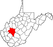
Coordinates: 38°20′14″N 81°42′13″W / 38.33722°N 81.70361°WCoordinates: 38°20′14″N 81°42′13″W / 38.33722°N 81.70361°W Country United States State West Virginia County Kanawha Elevation 594 ft (181 m) Time zone Eastern (EST) (UTC-5) – Summer (DST) EDT (UTC-4) Area code(s) 304 & 681 GNIS feature ID 1554264[1] Davis Creek is an unincorporated community in Kanawha County, West Virginia, United States. Davis Creek is located on West Virginia Route 214 2 miles (3.2 km) south of South Charleston.
References
Municipalities and communities of Kanawha County, West Virginia Cities Charleston | Dunbar | Marmet | Montgomery‡ | Nitro‡ | St. Albans | Smithers‡ | South Charleston
Towns Belle | Cedar Grove | Chesapeake | Clendenin | East Bank | Glasgow | Handley | Pratt
CDPs Alum Creek‡ | Big Chimney | Chelyan | Coal Fork | Cross Lanes | Elkview | Jefferson | Pinch | Rand | Shrewsbury | Sissonville | Upper Falls
Other
localitiesAarons | Acme | Acup | Amandaville | Amelia | Annfred | Barren Creek | Blackhawk | Blakeley | Blount | Blue Creek | Blundon | Bream | Brounland | Burnwell | Cabin Creek | Carbon | Cinco | Coalburg | Coalridge | Coco | Corton | Crede | Crown Hill | Davis Creek | Dawes | Decota | Dial | Diamond | Dickinson | Donwood | Dry Branch | Dungriff | Dupont City | East Nitro | East Side | Edgewood | Elk | Elk Forest | Elk Hills | Emmons‡ | Eskdale | Etowah | Falling Rock | Ferrell | Fivemile | Forest Hills | Forks of Coal | Fort Hill | Frame | Gallagher | Giles | Green Valley | Greencastle | Grippe | Guthrie | Hansford | Hernshaw | Hicumbottom | Highlawn | Hillsdale | Hitop | Holly | Hollygrove | Hollyhurst | Hugheston | Institute | Island Branch | Ivydale | Jarrett | Jarretts Ford | Joplin | Kanawha Estates | Kayford | Kelly Hill | Kendalia | Laing | Leewood | London | Lower Falls | Malden | Mammoth | Meadowbrook | Miami | Mink Shoals | Ohley | Pocatalico | Pond Gap | Port Amherst | Quick | River Bend | Riverside | Ruth | Ruthdale | Sharon | Snow Hill | Standard | Tad | Tornado | Victor | Wallace | Whittaker | Winifrede
Footnotes ‡This populated place also has portions in an adjacent county or counties
Categories:- Populated places in Kanawha County, West Virginia
- Unincorporated communities in West Virginia
- Kanawha County, West Virginia geography stubs


Wikimedia Foundation. 2010.