- December 2010 North American blizzard
-
For other 2010 blizzards in North America, see North American blizzards of 2010.
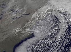
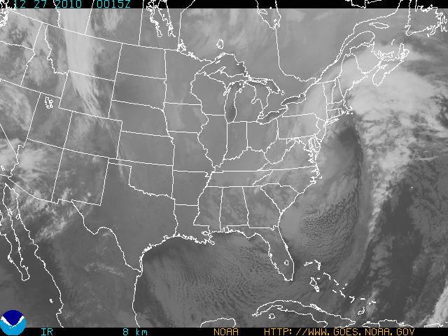
December 2010 North American blizzard Infrared satellite image of the storm on Monday, December 27, 2010 (Day 2)
Storm type: Blizzard Formed: December 22, 2010 (moved ashore in California)[citation needed] Dissipated: December 29, 2010[citation needed] Maximum
amount:*34 inches (86 cm) at Piscataway, New Jersey, Elizabeth, New Jersey, and Rahway, New Jersey.[1] Lowest
pressure:961 millibars (28.4 inHg)[2] Damages: $60 million (2010 USD)[citation needed] Fatalities: 7[citation needed] Areas affected: Deep South, Mid-Atlantic, New England, eastern Canada ^* Maximum snowfall or ice accretion
The December 2010 North American blizzard was a major nor'easter[3] and historic blizzard affecting the United States from portions of northern Florida to Maine and portions of Canada on December 26–27, 2010. It was the first significant winter storm of the 2010-11 winter season and the fourth North American blizzard of 2010. The storm affected the northeast megalopolis, which includes major cities such as Norfolk, Philadelphia, New York City, Hartford, Providence, and Boston. The storm brought between 12 and 32 inches (30 and 81 cm) of snow in many of these areas.
Contents
Meteorological history
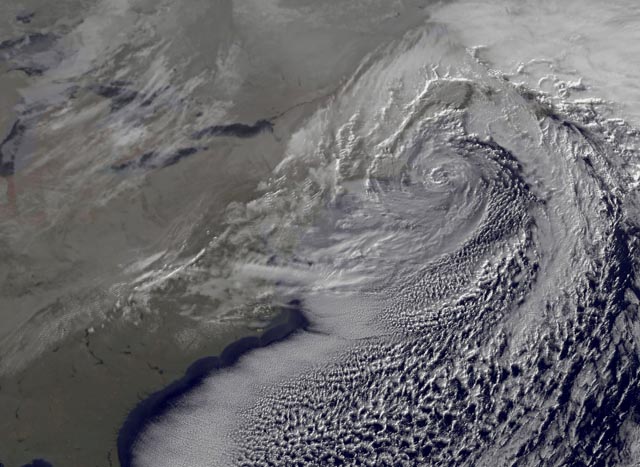
 Visible satellite imagery of the storm offshore Cape Cod on the morning of December 27
The main storm formed in Western Texas; however, its moisture was traced to a remnant storm that brought significant rain, snow, and mudslides to much of Southern California and the Desert Southwest. This system interacted with an upper-level low pressure system that dropped down from central Canada and an ample amount of southern stream energy; as a result, the storm carried a fairly large amount of moisture influx from the Pacific, Gulf of Mexico, and Atlantic Ocean. The core of the storm eventually moved southeast into the Gulf of Mexico then abruptly turned sharply northeastward into the Florida panhandle and state of Georgia as it merged with an upper-level low pressure system located near Virginia. As it became a stacked low pressure system, the storm system began a period of rapid intensification off the North Carolina coast while tracking along the coast of the Northeast and Newfoundland.
The storm had many similarities to North American blizzard of 2006. The storm also generated a rare meteorological phenomenon known as thundersnow in which thunder and lightning occur concurrently with the falling snow. On December 27, 2010, the storm had deepened to 961 millibars (28.4 inHg),[2] equal in pressure to that found in a Category 3 hurricane.[3] Several synoptic factors contributed to the intensity of this blizzard.[4]
The global American and European weather models encountered exceptional difficulty in portraying the path of the storm. The main issue that the models were trying to resolve was whether or not the upper-level low pressure system from Central Canada was going to phase in time with the southern stream energy, thereby revealing if the resulting storm would come up the Eastern Seaboard or simply continue to move east out to sea in the Atlantic Ocean. The latter solution would have only caused the storm to affect the Mid-Atlantic states of Virginia and North Carolina with a modest winter storm instead of the entire Eastern coastline up to Atlantic Canada. As such, it was only 24 hours prior to the storm's arrival in the Northeastern states when all the European and American models were in agreement that the storm would turn up the entire coastline. The National Weather Service's Hydrometeorological Prediction Center and many other private forecasters were skeptical of the storm impacting the Northeastern states until about 24 hours of the storm's arrival as well; although, some models depicted the storm delivering a full-blown blizzard to the New York City metropolitan area as early as a week in advance. The Hydrometeorological Prediction Center even issued a statement on Christmas Eve, 48 hours prior to the storm, that they suspected the American models of having model initialization errors; thus, they believed these errors may have forced the storm to be erroneously modeled to come up the Northeastern coast.[5]
Synoptic conditions
Snowfall
WCAU-TV in Philadelphia forecast a snowfall of between 10 and 20 inches (25 and 51 cm) in Philadelphia itself (which received 12.2 inches (31 cm)), while nearby Trenton, New Jersey and parts of southern New Jersey were expected to receive snowfalls of 20 inches (51 cm) or more. Wind gusts were expected to reach between 40 and 50 miles per hour (64 and 80 km/h).[6] Areas in eastern North Carolina and south eastern Virginia saw upwards of 12 inches (30 cm) of snow.
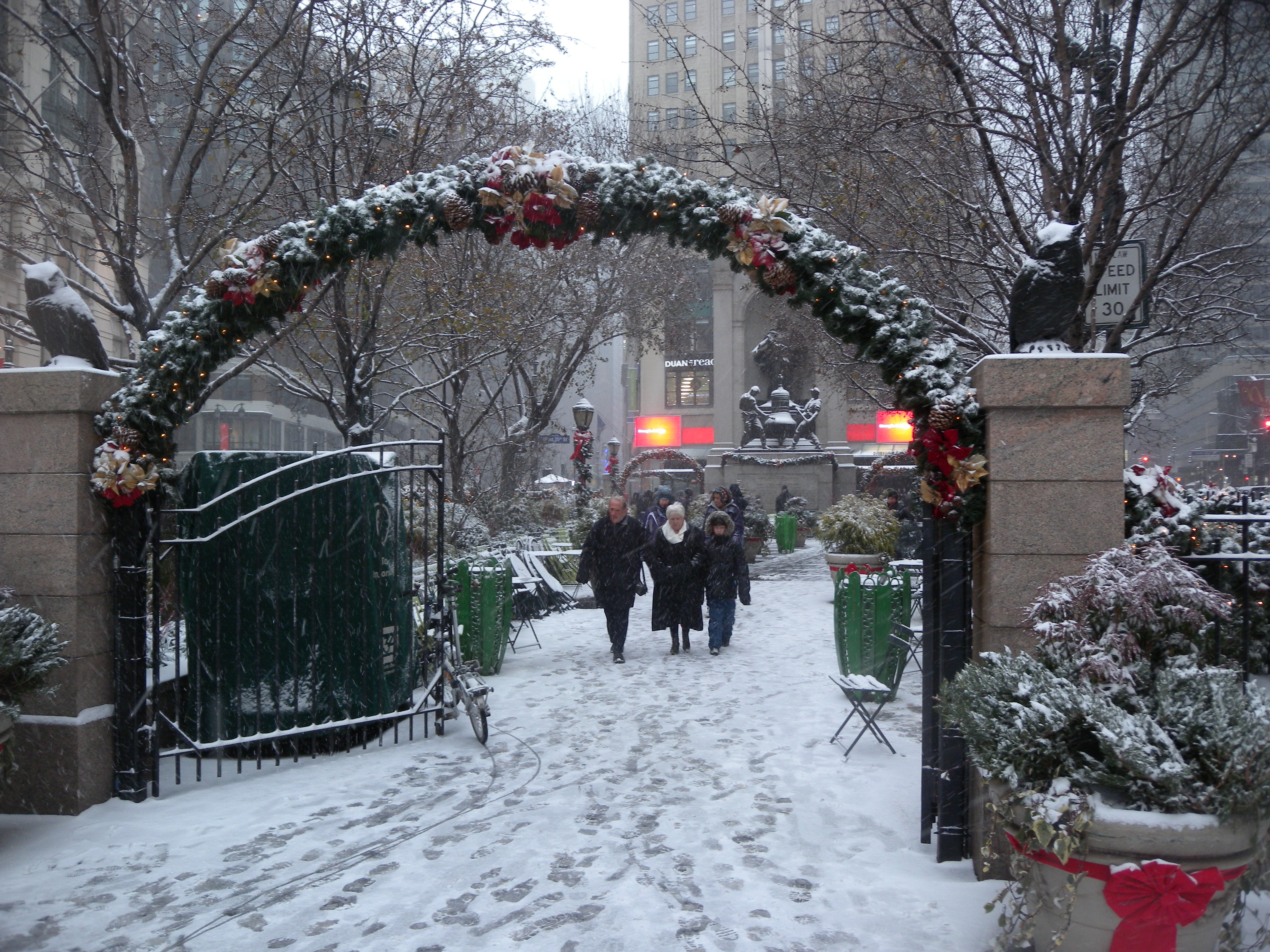
 Manhattan as snowfall begins
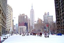 Broadway at end of snowfall
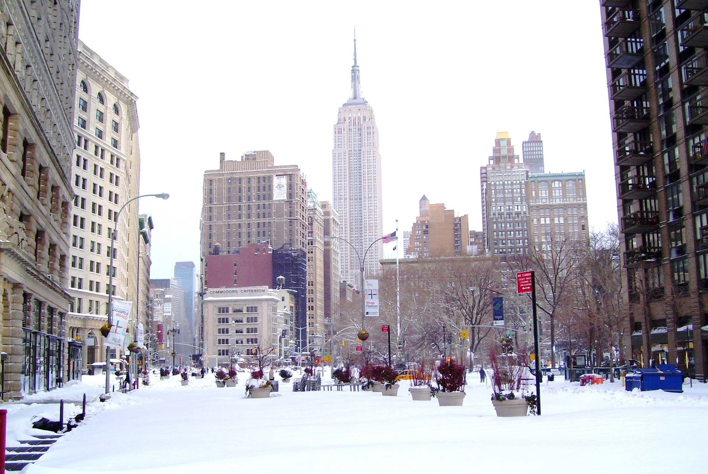
Areas in and around New York City, which were most impacted by the storm, reported between 12 and 32 inches (30 and 81 cm) of snowfall by Monday morning. Measurement was made difficult due to 4-foot (120 cm) snow drifts caused by the winds. Central Park's reported 20 inches (51 cm) of snow from the storm is the sixth-largest snowfall on record for that location.
Areas to the east of New York City received 10 to 20 inches while 20 to 30 inches of snow fell across the New York City, Northeast and Central New Jersey and Lower Hudson Valley.[4] Areas receiving the most snow are between New Brunswick and Elizabeth and between Brick and Atlantic City in New Jersey. This was because multiple convective bands of heavy snow fed in off the ocean into the large stationary very heavy snow band (with occasional lightning) over the areas that received 20 to 30 inches.[4] These areas received snowfall totals over 24.0 inches (61 cm). A secondary heavy snow/rain band formed across Eastern Massachusetts the night of December 26.[4] Southern New England including Boston saw more than 1 foot (30 cm) of snow. Even areas of coastal Virginia saw more than 1 foot (30 cm) of snow, and North Carolina received more than 6.0 inches (15 cm).[1]
Washington, D.C. and Baltimore and their environs were largely spared this storm, receiving little accumulation despite large snowfall totals further east on the Delmarva Peninsula.
High winds
Wind gusts routinely over 50 miles per hour (80 km/h) were widespread during the blizzard in coastal areas. Hurricane-strength wind gusts of 80 miles per hour (130 km/h) were recorded along coastal portions of Eastern Massachusetts.[1] A wind gust of 94.4 miles per hour (151.9 km/h) was recorded in Grand Etang, Nova Scotia.[7] The Greater New York area had sustained winds of 30-45 MPH with gusts to over 60 MPH during the afternoon and night of December 26.[4] High winds caused near zero visibilities and treacherous travel conditions in many areas. The strong easterly winds also piled up water along the eastern coast of Massachusetts, leading to major coastal flood damage.
Impact
Late on December 25, WPVI-TV announced that the National Weather Service had issued blizzard warnings for northern and parts of central New Jersey, New York City, Long Island and coastal southern New England.[8] WABC-TV also offered information on the blizzard warning that was posted throughout the New York City region.[9]
On December 26, several closures were announced on KYW-1060 (the all-news radio station in Philadelphia), including the Please Touch Museum and Independence National Historical Park.[10] Philadelphia mayor Michael Nutter declared a snow emergency beginning at 2:00 p.m. local time.[11] The NFL game between the Minnesota Vikings and the Philadelphia Eagles at Lincoln Financial Field in Philadelphia, scheduled for Sunday, December 26, was postponed until Tuesday, December 28.[12] Ironically, it was scheduled to be played Sunday afternoon, but flexed to the primetime slot, displacing the San Diego Chargers-Cincinnati Bengals game to the afternoon.
Boston declared a State of Emergency Sunday afternoon with an expected accumulation of over 20 inches (51 cm).[13]
Delaware had declared a State of Emergency on Sunday evening.[14]
Amtrak's Acela Express and regular Northeast Regional service was shut down completely between Boston and New York.[15]
North Carolina
North Carolina was one of six US states where a state of emergency was declared due to the storm.[16] Snow totals in the state ranged from less than 1 to 10 inches (2.5 to 25 cm) in the east, from 5 to 12 inches (13 to 30 cm) in the central part of the state, and from 3 to 15 inches (7.6 to 38 cm) in the west.[17]
 No trains running on the BMT Brighton Line as the result of the storm.New Yorkers cross a deep melt puddle (half minute video)
New York City
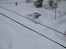
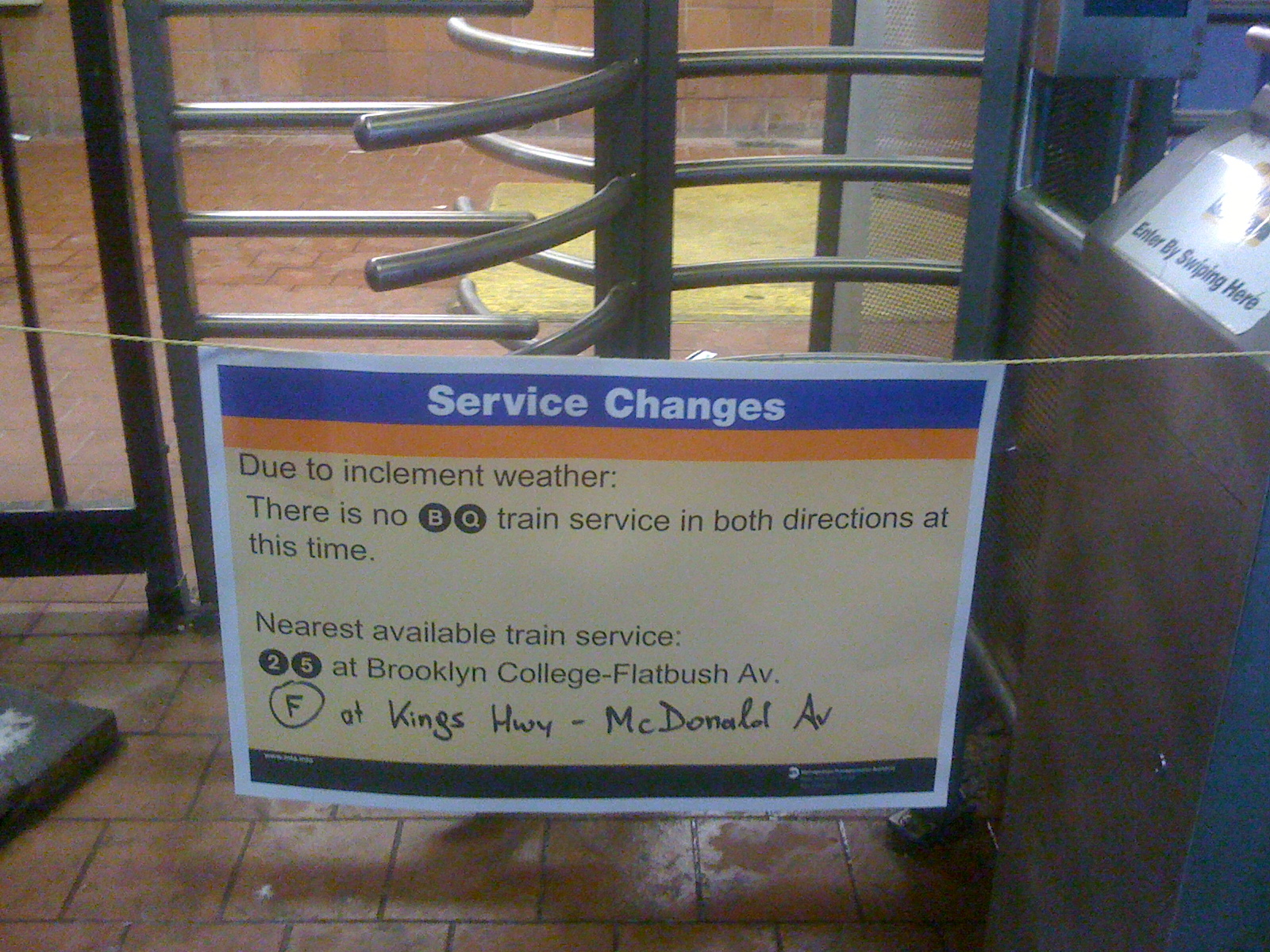
By the storm's end, weather stations in Central Park had recorded 20 inches (51 cm) of snow. A combination of heavy snow and strong winds led to massive transportation lockdowns across the city. Hundreds of buses were stuck in the snow.[18] More than 400 passengers were stranded on the A train on the IND Rockaway Line for seven hours starting shortly before 1 a.m.[19] One train did not open its doors when it stopped at the station. Dozens of LIRR trains were frozen onto the platforms. Hundreds of plows were on the road. NYC's major airports, Kennedy, Newark and LaGuardia were shut down until 6:00 p.m. Monday evening.[20] The MTA ran on a limited schedule, even on Tuesday morning, with many above ground subway lines not functioning. By Wednesday, only the Sea Beach Line, Franklin Avenue Line, and Greenport Branch remained suspended. The subway resumed full service on Thursday, the LIRR Friday morning.
Residents of the city were complaining to Mayor Michael Bloomberg about the slowness of the snowplows attempting to reach their areas. By the late afternoon on Tuesday, snowplows had reached the minor streets in Brooklyn. Many residents of Staten Island, however, had yet to see one. Many plows became stuck in the snow that had accumulated on the streets and several could not get through as many residents had simply abandoned their cars in the middle of roads once it became too hazardous or impossible to move. These cars became stuck as the snow accumulated around them, creating roadblocks for the plows. Both Mayor Bloomberg and the chief of the sanitation department were urging residents to stay indoors and not shovel snow back onto the streets that had already been plowed. State Senator Carl Kruger called the response a "Colossal Failure".[21]
Multiple explanations have been proposed for the relatively slow response of the snow cleanup in the New York City metropolitan area. For example, the local media did not fully alert the general public until Christmas Day about the impending storm due to the complexity and lateness of the forecast models predicting the storm; thus, public awareness was delayed. Another possible cause was that Mayor Bloomberg had previously laid off 400 New York City Sanitation workers due to budget cuts; therefore, fewer plows were at work. In addition, some city workers who are responsible for managing the snow removal process had taken the day off from work during the storm due to the Christmas holiday. Also, a snow emergency was not declared, contributing to the number of abandoned cars on the streets.
On December 30, the New York Post reported that several sanitation workers confessed that cleanup was intentionally slowed down to protest the aforementioned budget cuts.[22] On January 3, 2011, WCBS-TV reported that prosecutors had obtained a video of two sanitation trucks driving down 155th Street in Whitestone, Queens after the blizzard with their plows raised so as not to remove the snow. Allegations were also made that sanitation workers slept on the job, hung out at a doughnut shop for 11 straight hours while on the job, and drank beer for six or seven hours while on the job. Claims were also made that supervisors encouraged such work stoppages.[23] However, a month later, the New York Times reported that the allegations of a slowdown remained unsubstantiated and that Councilman Daniel Halloran, who had originally reported the confessions, had not named his sources.[24]
A man who attempted suicide by jumping from a ninth-story window was saved when he landed on a huge pile of garbage that had accumulated during the blizzard.[25]
Two casualties were reported as the result of emergency workers being unable to reach those in need: a newborn baby and an elderly woman.[26]
New Jersey
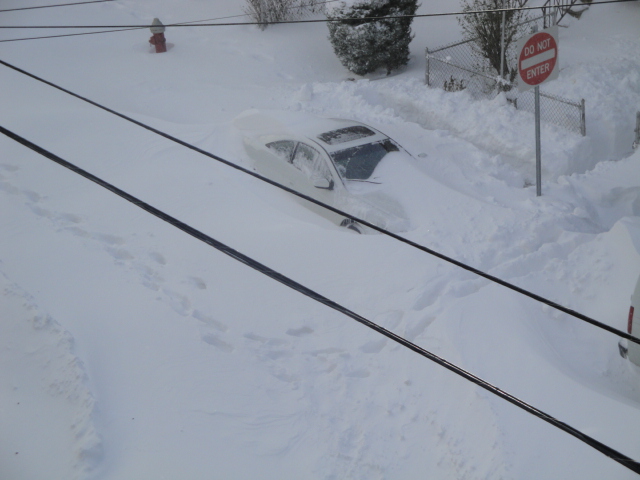
New Jersey declared a State of Emergency on Sunday, December 26.[27] They were affected the hardest because of its high winds and snow. Over 20 inches (51 cm) of snow was estimated in some counties such as Union County. Interstate 78, Interstate 80, and Interstate 280 experienced congestion, closures, and accidents. New Jersey Transit suspended all bus service, North Jersey Coast Line service, and Hudson-Bergen Light Rail Service. River Line service had partial closures and the Newark Light Rail was delayed for 20–30 minutes.[28] Many people in the state were stranded on roadways and only emergency vehicles were allowed on the roads.
The highest amount recorded was in Brick, New Jersey, where 36 inches of snow accumulated.[1] The visibility was near 0 miles (0 km). Central and Northeastern New Jersey were hit the hardest with snow totals of 1 to 2.5 feet (30 to 76 cm). Edison got 32.5 inches (83 cm), Lyndhurst got 29 inches (74 cm)[29] and Elizabeth had one of the highest totals of snow of any city affected by this storm, 31.8 inches (81 cm) of heavy snow. Blizzard Warnings were prompted for eastern New Jersey, while Winter Storm Warnings were issued in the western portion. Blowing and drifting snow was a big problem on December 26 and 27.
Newark Liberty International Airport in Newark had received 7 inches (18 cm) of snowfall in about three hours, an instance of very heavy snow in a short time. Snow drifts as high as seven feet were spotted in portions of eastern New Jersey. The NJ Transit was shut down on late December 26 due to blizzard conditions occurring in the area. Cape May was one of many southern New Jersey towns that were affected by snow bands containing four-inch per hour snowfall rates. When the storm was off the coast of New Jersey, bands of heavy snow formed one after another, increasing already-hefty snowfall amounts even further. There were reports of snow plows getting stuck in the snow late at night on December 26 and the early morning of the 27th. On the 26th, visibilities in some towns were less than 0.1 miles. This caused whiteout conditions in towns along the Raritan River and the Atlantic coastline.
Cape May had reported nearly 15 inches of snow after the storm had moved out to sea. The town had lesser snow amounts due to a break in the southern half of the snow bands pivoting toward New Jersey. The snow totals were only expected to reach 10 to 15 inches at the highest. Instead, the highest amount was in Brick, New Jersey where 36 inches fell, nearly 3 feet of snow fell. I-95 Northbound was mostly covered in layers of snow, which was dangerous for some drivers.
The higher snowfall amounts occurred in central and northern coastal areas of New Jersey. The blustery winds in New Jersey gusted as high as 65 mph. The fact of the high winds caused the blizzard warnings to be issued by the Mount Holly, New Jersey (Philadelphia, PA area) National Weather Service officials.
Snow fell so fast that traffic came to a complete halt. Motorists had to be rescued the following day as snow continued to pile up and trap them on interstates and local streets, which themselves became completely impassable. Citizens began calling in to news stations asking for help and giving reports, while plows and other emergency personnel became stuck everywhere. Newark Mayor Cory Booker notably used Twitter to help stranded residents and assure citizens.
Connecticut
Heavy snow and winds of up to 60 miles per hour (97 km/h) caused a gas station roof to collapse in North Haven, and widespread tree damage and power outages throughout the state. Service on the Metro-North New Haven Line and its branches was suspended on Monday due to equipment and switch failures caused by the storm.[30][31] The greatest snow totals were in the western part of the state, with Wilton receiving 18 inches of snow. North Canaan reported 16.1 inches, and 13.9 inches of snowfall was reported at Bradley International Airport.
The blizzard was nicknamed Winter Storm "Adrienne" by WFSB-TV Channel 3. The local CBS affiliate has unofficially named local winter storms since 1971.
Maine
Blizzard conditions arrived in Maine on December 27. On December 28, a ski lift at the Sugarloaf ski resort derailed, causing several skiers to receive injuries after falling to the ground, sending seven to the hospital.[32][33][34]
Massachusetts
Coastal Massachusetts, along with coastal Maine, bore the brunt of the storm with a recorded wind gust of 153 km/h (95 mph) in Scituate, Massachusetts.
Atlantic Canada
In Atlantic Canada, the nor'easter was the fourth major winter storm to hit the area in four weeks. Blizzard conditions forced numerous road closures and resulted in the death of a minivan driver on December 27 near Fredericton, Prince Edward Island. Wind gusts approached 150 km/h (93 mph), and up to 40 cm (16 in) of snow fell in New Brunswick, while Nova Scotia was hit by heavy rain and unseasonably warm temperatures and rain continued in eastern Newfoundland.[35][36]
See also
- February 5–6, 2010 North American blizzard
- February 9–10, 2010 North American blizzard
- February 25–27, 2010 North American blizzard
- March 2010 North American winter storm
- January 31 – February 2, 2011 North American blizzard
- North American blizzard of 2009
- North American blizzard of 2006
References
- ^ a b c d "National Weather Service Hydrometeorological Prediction Center Storm Summary Message". National Weather Service. December 28, 2010. http://www.hpc.ncep.noaa.gov/discussions/nfdscc1.html. Retrieved December 28, 2010.
- ^ a b "Storm Summary Number 11 for Eastern U.S. Winter Storm". National Weather Service. December 27, 2010. http://www.hpc.ncep.noaa.gov/winter_storm_summaries/storm20/stormsum_11.html. Retrieved December 29, 2010.
- ^ a b Andrew Freedman (December 27, 2010). "Blizzard blasts coastal cities from Va. to Mass.". The Washington Post. http://voices.washingtonpost.com/capitalweathergang/2010/12/blizzard_bypasses_dc_blasts_co.html.
- ^ a b c d e Case Study December 26-27th 2010 Blizzard National Weather Service New York, New York
- ^ "HPC's Case Study of the December 25-27 Northeast Blizzard"
- ^ "Heavy Snow Slams Region". Retrieved 2010-12-26.
- ^ Weather station history for CWZQ, Grand Etang, NS
- ^ WPVI-TV map showing counties affected by blizzard warning. Retrieved 2010-12-26.[verification needed]
- ^ WABC-TV page referencing blizzard warnings in NYC area. Retrieved 2010-12-26.[verification needed]
- ^ CBS Philadelphia page with closings. Retrieved 2010-12-26.[dead link]
- ^ "Nutter sets 2 p.m. snow emergency in Philly". Delaware Online. Retrieved 2010-12-26.
- ^ Philadelphia Eagles home page. Retrieved 2010-12-26.[verification needed]
- ^ Patrick declares state of emergency in Mass.. Associated Press. The Boston Globe. December 26, 2010.
- ^ "Gov. Markell declares limited state of emergency". Dover Post. 26 December 2010. http://www.doverpost.com/features/x1682036058/Gov-Markell-declares-limited-state-of-emergency. Retrieved 28 December 2010.
- ^ At South Station, passengers grapple with surprise shutdown by Amtrak
- ^ Tucker, Eric (2010-12-26). "East Coast storm strands travelers, vexes drivers". News & Observer. Associated Press. http://www.newsobserver.com/2010/12/26/882319/mid-atlantic-northeast-brace-for.html#storylink=misearch. Retrieved 2010-12-29.
- ^ "Snow tapers off, but morning commute will be dicey". News & Observer. 2010-12-26. http://www.newsobserver.com/2010/12/26/882363/overnight-snow-blankets-triangle.html#storylink=misearch. Retrieved 2010-12-29.
- ^ NYTimes, Dec 29, 2010 Hundreds of buses stranded
- ^ Andrew Grossman (December 27, 2010). "Snow Keeps City at Standstill". The Wall Street Journal. http://online.wsj.com/article/SB10001424052970203731004576046082386121562.html. Retrieved December 28, 2010.
- ^ Susan Carey (December 28, 2010). "Blizzard Strands Travelers Across U.S.". The Wall Street Journal. http://online.wsj.com/article/SB10001424052970203513204576047251243335300.html. Retrieved December 28, 2010.
- ^ "Slow Cleanup From Blizzard 2010"
- ^ Goldenberg, Sally; Celona, Larry; Margolin, Josh. "Sanitation Department's slow snow cleanup was a budget protest". New York Post. http://www.nypost.com/p/news/local/sanit_filthy_snow_slow_mo_qH57MZwC53QKOJlekSSDJK. Retrieved 2010-12-30.
- ^ Video Of Apparent Blizzard Clean-Up, Slow-Down Surfaces, WCBS-TV, January 3, 2011
- ^ Evidence Is Elusive on Charge of a Blizzard Slowdown, New York Times, January 25, 2011
- ^ Garbage breaks suicide jumper's fall, New York Post, January 2, 2011
- ^ Death of newborn baby among several blizzard tragedies as city is accused of 'dropping the ball'
- ^ Shore gets buried by blizzard, state of emergency declared APP.com December 26, 2010
- ^ Rahway, New JerseyTravelAlertsTo&rel=Bus Travel Alerts New Jersey Transit
- ^ "Update: Lots of snow, but no records, meteorologist says"
- ^ Blizzard Warnings Remain in Effect, Thousands Without Power, WTNH-TV New Haven, CT, December 27, 2010
- ^ Liz Robbins (December 26, 2010). "After Blizzard Ends, a Slow Recovery". The New York Times. http://www.nytimes.com/2010/12/28/nyregion/28blizzard.html. Retrieved December 28, 2010.
- ^ Paulson, Amanda (December 28, 2010). "Sugarloaf Mountain: How common are serious ski lift accidents?". The Christian Science Monitor. http://www.csmonitor.com/USA/2010/1228/Sugarloaf-Mountain-How-common-are-serious-ski-lift-accidents. Retrieved December 28, 2010.
- ^ Kamlet, Lee (December 28, 2010). "Skiers Plummet When Maine Ski Lift Derails". ABC News. http://abcnews.go.com/US/skiers-trapped-injured-sugarloaf-mountain-ski-lift-derailment/story?id=12492517. Retrieved December 28, 2010.
- ^ News, South Hill (December 28, 2010). "Southside Va. treated to a white Christmas". Smith Hill Enterprise. http://www.vancnews.com/articles/2010/12/28/south_hill/news/news41.txt. Retrieved 28 December 2010.
- ^ Cohen, Tobi; Mike Barber (December 28, 2010). "Winter batters Atlantic Canada". The Vancouver Sun. http://www.vancouversun.com/sports/Winter+batters+Atlantic+Canada/4031864/story.html. Retrieved December 28, 2010.
- ^ News, CBC (December 27, 2010). "East Coast snowstorm pummels region". Canadian Broadcasting Corporation. http://www.cbc.ca/canada/new-brunswick/story/2010/12/27/nb-maritimes-storm.html. Retrieved December 28, 2010.
External links
- Timelapse Video – Sped-up footage of the blizzard
- December 26-27, 2010 Blizzard National Weather Service, New York, New York
- "The blizzard of 2010", The Boston Globe
- "December 26-27, 2010 Snowstorm", National Weather Service Eastern Region Headquarters
- "Neptune Digs Out", Asbury Park Press
Blizzards in the United States 19th century 20th century 21st century Categories:- 2010 meteorology
- 2010 natural disasters in the United States
- Blizzards in the United States
- Natural disasters in Massachusetts
- Nor'easters

Wikimedia Foundation. 2010.