- Deer Island Thorofare Light
-
Deer Island Thorofare Light 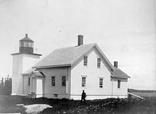
Location Penobscot Bay, Maine Coordinates 44°8′3.721″N 68°42′11.785″W / 44.13436694°N 68.70327361°WCoordinates: 44°8′3.721″N 68°42′11.785″W / 44.13436694°N 68.70327361°W Year first constructed 1857 Automated 1958 Foundation Masonry Construction Brick Tower shape Square tower Markings / pattern White with black lantern and trim Focal height 52ft (16m) Original lens 4th order Fresnel Lens Current lens 250mm Range 8nm Characteristic Fl W 6s Fog signal Original: Bell
Current: Horn: 1 every 15s, operates continuouslyAdmiralty number J0073 ARLHS number USA-221 USCG number 1-3095 Deer Island Thorofare Light, also known as Mark Island Light [4], is a lighthouse on Penobscot Bay, Maine, about 1.8 nm west-southwest of Stonington. It was built in 1857.
History
The station was established in 1857 with the building of the current small square brick tower and a keeper's house. It was built at the time that the granite quarries on Deer Isle and Crotch Island, immediately to the east, were becoming important for the construction of public buildings throughout the eastern United States. It was automated in 1958. The keeper's house burned down in 1959 and the rest of the buildings were removed shortly thereafter. In 1998 control of the site was passed to the Island Heritage Trust, a local group which preserves historic sites in the area. They have promised to keep the island as a bird sanctuary.[3]
Location and Nomenclature
It sits on a small island at the west end of the Deer Island Thorofare and of Merchant Row, two east-west passages among the small islands which lie between Deer Isle and Isle au Haut. The island is called "Mark Island" on NOAA charts 13302 and 13313, but "Marks Island" on the larger scale chart 13315. The light is called "Mark Island Light" on an early 20th century postcard and is still locally referred to by that name. Also confusing is that the large island to the north and the town on it are "Deer Isle", but the passage is "Deer Island Thorofare".
References
- ^ "Historic Light Station Information and Photography: Maine". United States Coast Guard Historian's Office. 2009-08-06. http://www.uscg.mil/history/weblighthouses/LHME.asp.
- ^ United States Coast Guard (2009). Light List, Volume I, Atlantic Coast, St. Croix River, Maine to Shrewsbury River, New Jersey. p. 29.
- ^ a b Rowlett, Russ (2009-10-03). "Lighthouses of the United States: Eastern Maine". The Lighthouse Directory. University of North Carolina at Chapel Hill. http://www.unc.edu/~rowlett/lighthouse/me.htm.
- ^ Deer Isle Lighthouse Trail
Lighthouses of Maine Avery Rock Light · Baker Island Light · Bass Harbor Head Light · Bear Island Light · Blue Hill Bay Light · Boon Island Light · Browns Head Light · Burnt Coat Harbor Light · Burnt Island Light · Cape Elizabeth Lights · Cape Neddick Light · Crabtree Ledge Light · The Cuckolds Light · Curtis Island Light · Deer Island Thorofare Light · Dice Head Light · Doubling Point Light · Doubling Point Range Lights · Eagle Island Light · Egg Rock Light · Fiddler's Reach Fog Signal · Fort Point Light · Franklin Island Light · Goat Island Light · Goose Rocks Light · Great Duck Island Light · Grindel Point Light · Halfway Rock Light · Hendricks Head Light · Heron Neck Light · Indian Island Light · Isle Au Haut Light · Kennebunkport Breakwater Light · Ladies Delight Light · Libby Island Light · Little River Light · Lubec Channel Light · Manana Island Sound Signal Station · Marshall Point Light · Matinicus Rock Light · Monhegan Island Light · Moose Peak Light · Mount Desert Light · Narraguagus Light · Nash Island Light · Owls Head Light · Pemaquid Point Light · Perkins Island Light · Petit Manan Light · Pond Island Light · Portland Breakwater Light · Portland Head Light · Prospect Harbor Point Light · Pumpkin Island Light · Ram Island Light · Ram Island Ledge Light · Rockland Harbor Breakwater Light · Saddleback Ledge Light · Saint Croix River Light · Seguin Light · Spring Point Ledge Light · Squirrel Point Light · Tenants Harbor Light · Two Bush Island Light · West Quoddy Head Light · Whaleback Light · Whitehead Light · Whitlocks Mill Light · Winter Harbor Light · Wood Island Light Portland Head Light
 Categories:
- Lighthouses in Maine
- Buildings and structures completed in 1857
- Lighthouses in Hancock County, Maine
- United States lighthouse stubs

Wikimedia Foundation. 2010.