- Demographics of Madras Presidency
-
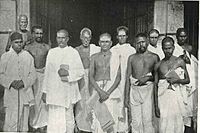 Census superintendent and enumerators in Pasumalai, Madras Presidency, circa 1911
The first census of the Madras Presidency was taken in the year 1822.[1] It returned a population of 13,476,923.[1] The second census conducted in 1836-37 returned a population of 13,967,395, an increase of only 490,472 in 15 years.[1] The first quinquennial enumeration of the population was made in 1851-52. It returned a population of 22,031,697.[1] Subsequent enumerations were made in 1856-57, 1861–62 and 1866-67. The population of Madras Presidency was found to be 22,857,855 in 1851-52, 24,656,509 in 1861-62 and 26,539,052 in 1866-67.[1]
The first organized census of India was conducted in 1871. It returned a population of 31,220,973 for Madras Presidency. Since then, a census has been conducted once every ten years. The last census of British India held in 1941 returned a population of 49,341,810 for Madras Presidency.
Districts and Agencies of Madras Presidency District District Headquarters Area (in square miles) Year of incorporation Population 1871 1881 1891 1901 1911 1921 1931 1941 Anantapur Anantapur 5,557 1800 741,255 599,899 727,725 788,254 963,223 1,166,255 Bellary Bellary 5,714 1800 911,755 726,275 880,950 947,214 969,436 Chingleput Saidapet 5,079 1763 938,184 981,381 1,202,928 1,312,122 1,321,000 Coimbatore Coimbatore 7,860 1799 1,763,274 1,657,690 2,004,839 2,201,752 Cuddapah Cuddapah 8,723 1800 1,351,194 1,121,038 1,272,072 1,291,267 East Godavari[2] Cocanada 1765 - - - - - - 1,756,477 1,976,743 Ganjam[3] Berhampur 8,372 1765 1,520,088 1,749,604 1,896,803 2,010,256 - Godavari[2] Cocanada 7,972 1765 1,592,939 1,791,512 2,078,782 2,301,759 1,530,000 2,583,250 - - Kistna Masulipatam 8,498 1765/1801 1,452,374 1,548,480 1,855,582 2,154,803 1,997,535 Kurnool Kurnool 7,878 1800 914,432 678,551 817,811 872,055 889,000 Madras Madras 27 1639 367,552 405,848 452,518 509,346 518,660 526,000 645,000 776,000 Madura Madura 8,701 1761/1790/1801 2,266,615 2,168,680 2,608,404 2,831,280 1,861,000 Malabar Calicut 5,795 1792 2,261,250 2,365,035 2,652,565 2,800,555 3,015,119 Nellore Nellore 8,761 1781 1,376,811 1,220,236 1,463,736 1,496,987 1,296,000 Nilgiris Ootacamund 958 1799 49,501 91,034 99,797 111,437 80,000 North Arcot Chittoor 7,386 1781/1801 2,015,278 1,817,814 2,114,487 2,207,712 1,822,000 Salem Salem 7,530 1792 1,966,995 1,599,595 1,962,591 2,204,974 1,766,680 South Arcot Cuddalore 5,217 1781/1801 1,755,817 1,814,738 2,162,851 2,349,894 2,272,000 South Kanara Mangalore 4,021 1799 918,362 959,514 1,056,081 1,134,713 Tanjore Tanjore 3,710 1799 1,973,731 2,130,383 2,228,114 2,245,029 2,362,639 Tinnevely Tinnevely 5,389 1761/1801 1,693,959 1,699,747 1,916,095 2,059,607 Trichinopoly Trichinopoly 2,632 1781/1801 1,200,408 1,215,033 1,372,717 1,444,770 Vizagapatam Waltair 17,222 1794 2,159,199 2,485,141 2,802,992 2,933,650 2,231,874 West Godavari[2] Eluru 1765 - - - - - - Total Madras 141,705 31,220,973 30,827,218 35,630,440 38,209,436 41,870,160 42,794,155 46,740,107[2] 49,341,810[3] Princely States of Madras Presidency Banganapalle Banganapalle 255 45,208 30,754 34,596 32,264 Cochin Cochin 1,362 601,114 600,278 722,906 812,025 979,080 918,110 1,205,016 1,422,875 Pudukkottai Pudukkottai 1,100 316,695 302,127 373,096 380,440 411,886 426,313 400,694 Sandur Sandur 161 14,996 10,532 11,388 11,200 Travancore Trivandrum 7,091 2,311,379 2,401,158 2,557,736 2,952,157 3,428,975 4,006,062 5,095,973 6,070,018 Source: The Imperial Gazetteer of India Cities
Position 1871 1881 1891 1901 1911 1921 1931 1941 1 Madras (367,552) Madras (405,848) Madras (452,518) Madras (509,346) Madras (526,911) Madras (777,481) 2 Madura (76,530) Madura(84,449) Madura(90,609) Madura (105,984) Madura (138,894) Madura (239,144) 3 Tanjore (52,171) Trichinopoly (73,807) Trichinopoly (87,428) Trichinopoly (104,721) Trichinopoly (120,422) Trichinopoly (159,566) 4 Trichinopoly (51,987) Calicut (57,085) Salem (67,710) Calicut (76,981) Calicut (82,334) Coimbatore (130,348) 5 Bellary (51,766) Tanjore (54,745) Calicut (66,078) Salem (70,621) Coimbatore (65,788) Salem (129,702) 6 Salem (50,012) Negapatam (53,855) Bellary (59,447) Kumbakonam (59,673) Kumbakonam (60,700) 7 Negapatam (48,525) Bellary (53,460) Negapatam (59,221) Bellary (58,247) Tanjore (59,913) 8 Calicut (48,338) Salem (50,667) Tanjore (54,390) Tanjore (57,870) Negapatam (54,016) 9 Kumbakonam (44,444) Kumbakonam (54,307) Kumbakonam (54,307) Negapatam (57,190) Cocanada (53,348) 10 Coimbatore (35,310) Coimbatore (38,967) Coimbatore (46,383) Coimbatore (53,080) Salem (52,244) Notes
Categories:- Madras Presidency
- Tamil society
- Demographic history of India

Wikimedia Foundation. 2010.