- Den Helder–Amsterdam railway
-
Den Helder–Amsterdam railway 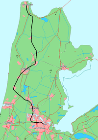
Overview Status Operational Locale The Netherlands Termini Den Helder railway station
Amsterdam Centraal railway stationOperation Opened 1865-1878 Operator(s) Nederlandse Spoorwegen Technical Line length 83 km (52 mi) No. of tracks single track (Den Helder–Schagen),
double track (Schagen–Amsterdam)Track gauge 1,435 mm (4 ft 8 1⁄2 in) Standard gauge Electrification 1.5 kV DC Route map Legend
0.6 Den Helder 


3.4 Den Helder Zuid 12.1 Anna Paulowna 21.3 Schagen 

from Hoorn 35.2 Heerhugowaard 40.2 Alkmaar Noord 
42.1 Alkmaar 48.0 Heiloo 53.9 Castricum 57.7 Uitgeest 

to Haarlem 62.3 Krommenie-Assendelft 65.1 Wormerveer 67.7 Koog-Zaandijk 68.8 Koog Bloemwijk Line from Enkhuizen 71.2 Zaandam 

North Sea Canal 


Line from Haarlem 


Amsterdam Sloterdijk (Hemboog) 
78.9 Amsterdam Sloterdijk 
Line to Schiphol 
83.3 Amsterdam Centraal Lines to Utrecht and Amersfoort The Den Helder–Amsterdam railway is a railway line in the Netherlands running from Den Helder to Amsterdam, passing through Alkmaar and Zaandam. It is also called the Staatslijn K ("state line K") in Dutch. The line is 81 km long.
The following stations are on Staatslijn K:
- Den Helder
- Den Helder Zuid
- Anna Paulowna
- Schagen
- Heerhugowaard
- Alkmaar Noord
- Alkmaar
- Heiloo
- Castricum
- Uitgeest
- Krommenie-Assendelft
- Wormerveer
- Koog-Zaandijk
- Koog Bloemwijk
- Zaandam
- Amsterdam Sloterdijk
- Amsterdam Centraal
History
The line began construction on 18 August 1860 and on 18 December 1865 the first section opened.
The sections were opened on:
- 18 December 1865 - Den Helder - Alkmaar
- 1 May 1867 - Alkmaar - Uitgeest
- 1 November 1869 - Uitgeest - Zaandam
- 15 May 1878 - Zaandam - Amsterdam Willemspoort
- 15 October 1878 - Amsterdam Willemspoort - Amsterdam Oosterdok
The line between Alkmaar and Amsterdam was electrified in 1931 and between Den Helder and Alkmaar in 1958.
The following stations were opened at the same time as the sections of the line were opened:
- Den Helder
- Anna Paulowna
- Schagen
- Noord Scharwoude
- Heerhugowaard
- Alkmaar
- Castricum
- Uitgeest
- Krommenie-Assendelft
- Wormerveer
- Koog-Zaandijk
- Zaandam
- Amsterdam Westerdok
Categories:- Railway lines in the Netherlands

Wikimedia Foundation. 2010.