- Desert Center Airport
-
Desert Center Airport 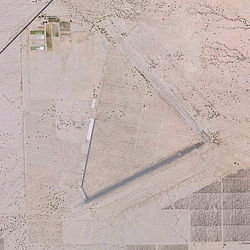
2006 USGS photo IATA: none – ICAO: none – FAA LID: L64 Summary Airport type Public Owner Chuckwalla Valley Associates, LLC Location Desert Center, California Elevation AMSL 559 ft / 170 m Coordinates 33°44′52″N 115°19′30″W / 33.74778°N 115.325°W Runways Direction Length Surface ft m 5/23 4,200 1,280 
 Desert Center AirportLocation of Desert Center Airport, California
Desert Center Airport (FAA LID: L64) is a public airport located at the end of an unnamed road, one mile (1.6 km) east of CA Route 177 (Desert Center - Rice Road), 5 miles (8.0 km) northeast of the town of Desert Center, California, 127 miles (204 km) northeast of San Diego.
Contents
History
World War II use
Desert Center Army Airfield was built in the early 1940s was a subbase of Thermal Army Airfield and served as a support base for the Air Technical Service Command. The airfield was located within the Desert Center Division Camp,which encompassed over 34,000 acres (140 km2). Desert Center was one of the areas included in the California Arizona Maneuver Area, used during 1942-44 to train General Patton's armored forces for desert combat prior to it deploying to North Africa.
Desert Center Army Airfield was first known as the Desert Center Airdrome. According to a history of the 1st, 2nd, and 3rd Airdrome Detachments, a detachment of the 475th Base Headquarters & Air Base Squadron was the first administrative unit stationed at Desert Center, arriving in 15 January 1943. It was described as having 5,500' runways. The field also had taxiways & a parking apron. More than 40 buildings were constructed at the airfield, including an operations building, power house, Link Trainer building, hangar and various supply buildings. The 74th Reconnaissance Group was the first flying unit at the field, arriving in December 1942 while the facility was under construction. It was variously equipped with O-52s, L-1s, L-4s, B-25s, P-39s and P-40s and trained to provide air support and reconnaissance to the Army ground forces training at the desert combat training facility.[1]
Desert Center AAF was officially opened in April 1943. The 3d Airdrome Detachment was activated on 1 August to maintain the installation and assist in the administration and training of tactical organizations stationed at the airfield for training and maneuvers.[2]
When the training area closed in 1944, the airfield was assigned to the Fourth Air Force, and operational activities decreased greatly. The airfield remained open, however, and was used by B-24 Liberator crews flying training missions from March Field.
Civil use
In 1946, following the end of World War II, the airfield was turned over to the Army Corps of Engineers, and the buildings were auctioned off to the public.
It was listed as "Desert Center CAA Site 17" in the "Aerodromes" table on the 1955 San Diego Sectional Aeronautical Chart. It described the field as having two 5,000' bituminous runways. The airfield was listed among active airports in the 1962 AOPA Airport Directory, under the name of "FAA Site 17". It was described as having two 5,000 ft bituminous runways: 13/31 & 4/22, and the operator was listed as the FAA. It was closed in the mid-1960s, but listed as an emergency airfield.
The airport was reopened as a civil airport (owned by Riverside County) at some point between 1966-2002. However, as of 2002 it was all but abandoned. There were no aircraft based at the field, and the Airport Facility Directory data listed a mere 150 takeoffs & landings per year. The sole remaining maintained runway is 5/23, which consists of a 4,200 ft asphalt strip which was overlaid over remains of the original military runway.[3] Two buildings were still standing.
Recent history
Today, there are remains of Patton’s army all around the airport including foundations from the old buildings and pieces of discarded equipment mixed in with the remains of old agriculture & vandalism. The abandoned Runway 13/31 is barely discernible, covered with sand & bushes. There are no historic buildings left, although there are numerous foundations & a concrete parking ramp.
In 2003, the airfield was being used to fly unmanned aircraft. The hangar had been converted to a workshop & an inclined launching ramp was constructed.
In 2004 the airfield was again put up for sale by Riverside County and bought by Chuckwalla Valley Associates, LLC, to service the new Chuckwalla Valley Raceway.
See also
References
 This article incorporates public domain material from websites or documents of the Air Force Historical Research Agency.
- Maurer, Maurer (1983). Air Force Combat Units Of World War II. Maxwell AFB, Alabama: Office of Air Force History. ISBN 0892010924.
- Mauer, Mauer (1969), Combat Squadrons of the Air Force, World War II, Air Force Historical Studies Office, Maxwell AFB, Alabama. ISBN 0892010975
- Shaw, Frederick J. (2004), Locating Air Force Base Sites History’s Legacy, Air Force History and Museums Program, United States Air Force, Washington DC, 2004.
- Thole, Lou (1999), Forgotten Fields of America : World War II Bases and Training, Then and Now - Vol. 2. Publisher: Pictorial Histories Pub, ISBN 1575100517
- ^ 00099366
- ^ USAFHRA Document 00011254
- ^ "FAA Airport Master Record" (PDF). Federal Aviation Administration. 8 April 2010. http://www.gcr1.com/5010web/Rpt_5010.asp?au=PU&o=PU&faasite=01507.*A&fn=L64.
External links
- Desert Center USA
- Resources for this airport:
- AirNav airport information for L64
- FlightAware airport information and live flight tracker
- SkyVector aeronautical chart for L64
Airfields Group Training Stations · Replacement Training Stations · Tactical Airfields
Units Commands IV Bomber Command · IV Fighter Command · IV Air Support CommandWings 21st Bombardment · Los Angeles Fighter · San Diego Fighter · San Francisco Fighter · Seattle FighterGroups Bombardment 12th Bombardment · 30th Bombardment · 41st Bombardment · 42d Bombardment · 47th Bombardment · 380th Bombardment · 385th Bombardment · 389th Bombardment · 392d Bombardment · 399th Bombardment · 449th Bombardment · 450th Bombardment · 451st Bombardment · 453rd Bombardment · 454th Bombardment · 455th Bombardment · 456th Bombardment · 461st Bombardment · 463d Bombardment · 465th Bombardment · 466th Bombardment · 470th Bombardment · 483rd Bombardment · 486th Bombardment · 491st Bombardment · 492d BombardmentFighter 1st Fighter · 14th Fighter · 20th Fighter · 35th Fighter · 51st Fighter · 55th Fighter · 78th Fighter · 81st Fighter · 82d Fighter · 328th Fighter · 329th Fighter · 339th Fighter · 354th Fighter · 360th Fighter · 363rd Fighter · 364th Fighter · 369th Fighter · 367th Fighter · 372d Fighter · 412th Fighter · 473d Fighter · 474th Fighter · 478th Fighter · 479th FighterReconnaissance 68th Reconnaissance · 69th ReconnaissanceTroop Carrier Categories:- Airports in Riverside County, California
- World War II Desert Airfields
- USAAF Fourth Air Force Tactical Airfields
- USAAF Fourth Air Force Group Training Stations
- Airfields of the United States Army Air Forces in California
- 1942 establishments


Wikimedia Foundation. 2010.