- Morgantown Municipal Airport
-
Morgantown Municipal Airport
Walter L. Bill Hart Field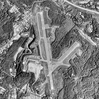
USGS aerial image, 1988 IATA: MGW – ICAO: KMGW – FAA LID: MGW Summary Airport type Public Owner City of Morgantown Serves Morgantown, West Virginia Elevation AMSL 1,248 ft / 380 m Coordinates 39°38′34″N 079°54′59″W / 39.64278°N 79.91639°WCoordinates: 39°38′34″N 079°54′59″W / 39.64278°N 79.91639°W Website Map Location of airport in West Virginia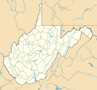
 MGW
MGWRunways Direction Length Surface ft m 18/36 5,199 1,585 Asphalt Statistics (2009) Aircraft operations 43,430 Based aircraft 51 Source: Federal Aviation Administration[1] Morgantown Municipal Airport (IATA: MGW, ICAO: KMGW, FAA LID: MGW), also known as Walter L. Bill Hart Field, is a public-use airport located three nautical miles (4 mi, 6 km) east of the central business district of Morgantown, in Monongalia County, West Virginia, United States.[1] The airport is owned by the City of Morgantown.[1] It is mostly used for general aviation, but is also served by one commercial airline, United Express.
As per Federal Aviation Administration records, the airport had 11,249 passenger boardings (enplanements) in calendar year 2010, a decrease of 4.1% from the 11,727 enplanements in 2009.[2] This airport is included in the FAA's National Plan of Integrated Airport Systems for 2011–2015, which categorized it as a primary commercial service airport (more than 10,000 enplanements per year).[3]
While the airport's runway cannot handle larger airplanes, it has filed a request with the Federal Aviation Administration to lengthen the runway.[4]
Contents
Facilities and aircraft
The airport covers an area of 638 acres (258 ha) at an elevation of 1,248 feet (380 m) above mean sea level. It has one runway designated 18/36 with an asphalt surface measuring 5,199 by 150 feet (1,585 x 46 m).[1]
For the 12-month period ending December 31, 2009, the airport had 43,430 aircraft operations, an average of 118 per day: 66% general aviation, 23% air taxi, and 11% military. At that time there were 51 aircraft based at this airport: 82% single-engine, 12% multi-engine, 4% jet, and 2% helicopter.[1]
Airline and destinations
Airlines Destinations United Express operated by Colgan Air Clarksburg, Washington-Dulles References
- ^ a b c d e FAA Airport Master Record for MGW (Form 5010 PDF). Federal Aviation Administration. Effective 25 August 2011.
- ^ "Primary, Non-primary Commercial Service, and General Aviation Airports (by State) (PDF, 5.4 MB)". CY 2010 Passenger Boarding and All-Cargo Data. Federal Aviation Administration. 4 October 2011. http://www.faa.gov/airports/planning_capacity/passenger_allcargo_stats/passenger/media/cy10_all_enplanements.pdf.
- ^ "2011–2015 NPIAS Report, Appendix A (PDF, 2.03 MB)". 2011–2015 National Plan of Integrated Airport Systems. Federal Aviation Administration. 4 October 2010. http://www.faa.gov/airports/planning_capacity/npias/reports/media/2011/npias_2011_appA.pdf.
- ^ Moniot, Stacy (November 1, 2011). "Big 12 Conference Shift Won't 'Significantly' Impact Morgantown Airport". WVNS-TV (West Virginia Media Holdings, LLC).
External links
- Morgantown Municipal Airport, official web site
- Morgantown Municipal Airport from 2008 West Virginia DOT Airport Directory
- Aerial image as of 18 June 1988 from USGS The National Map
- FAA Airport Diagram (PDF), effective 20 October 2011
- FAA Terminal Procedures for MGW, effective 20 October 2011
- Resources for this airport:
- AirNav airport information for KMGW
- ASN accident history for MGW
- FlightAware airport information and live flight tracker
- NOAA/NWS latest weather observations
- SkyVector aeronautical chart for KMGW
- FAA current MGW delay information
Categories:- Airports in West Virginia
- Essential Air Service
- Transportation in Monongalia County, West Virginia
- Buildings and structures in Monongalia County, West Virginia


Wikimedia Foundation. 2010.