- Draining of the Mesopotamian Marshes
-
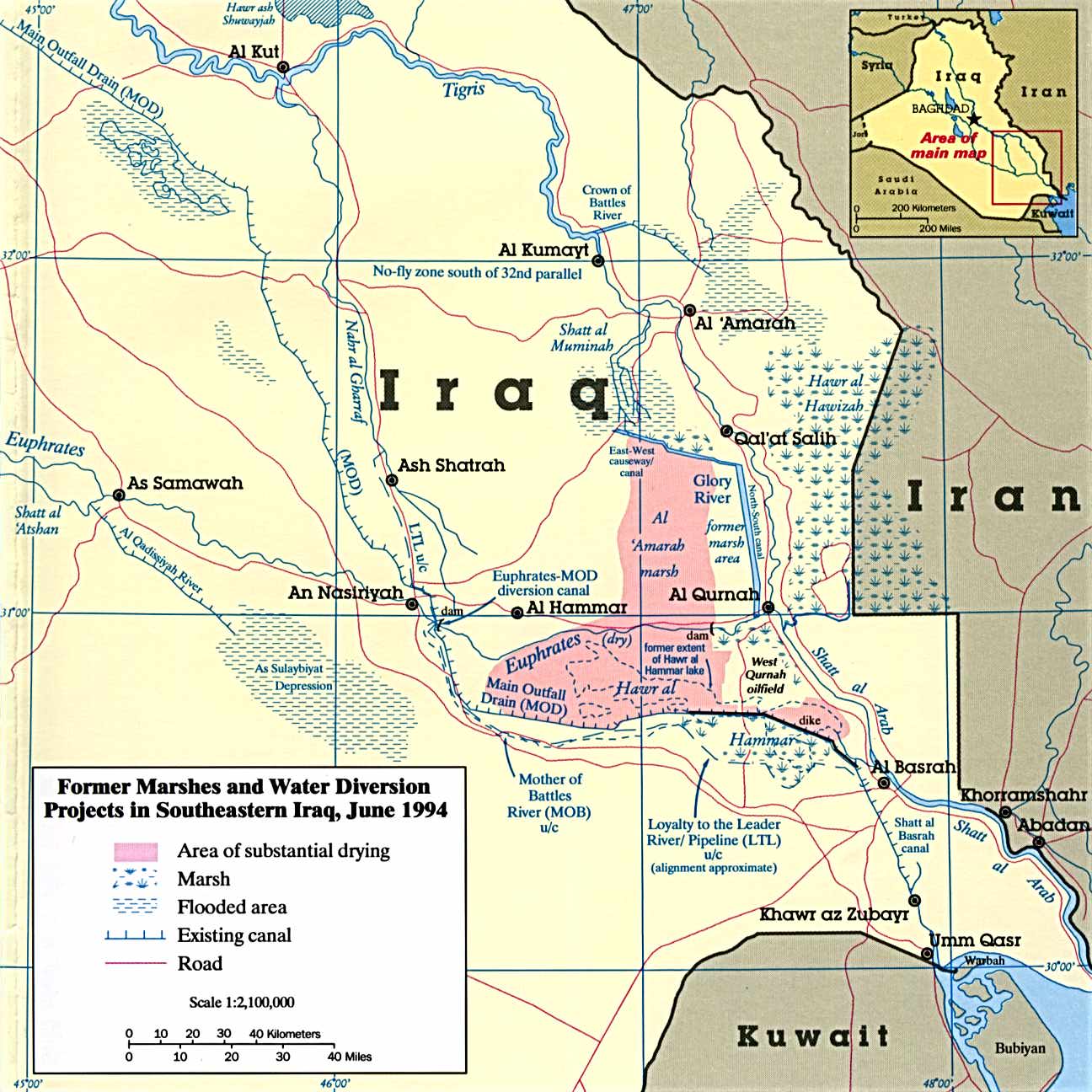
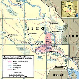 1994 map of the Mesopotamian Marshes with draining features.
The Draining of the Mesopotamian Marshes occurred in Iraq and to a smaller degree in Iran between the 1950s and 1990s to clear large areas of the marshes in the Tigris-Euphrates river system. Formerly covering an area of around 20,000 km2 (7,700 sq mi), the large complex of wetlands was 90% drained prior to the 2003 Invasion of Iraq. The marshes are typically divided into three main sub-marshes, the Hawizeh, Central, and Hammar Marshes and all three were drained at different times for different reasons. Initial draining of the Central Marshes was intended to reclaim land for agriculture but later all three marshes would become a tool of war and revenge.
Many international organizations such as the U.N. Human Rights Commission, the Supreme Council of the Islamic Revolution in Iraq (SCIRI), the International Wildfowl and Wetlands Research Bureau, and Middle East Watch have described the draining as a political attempt to force the Ma'dan people out of the area through water diversion tactics.[1]
Contents
History
The marshes had for some time been considered a refuge for elements persecuted by the government of Saddam Hussein, as in past centuries they had been a refuge for escaped slaves and serfs, such as during the Zanj Rebellion. The area was formerly populated by the Marsh Arabs or Ma'dan, who grazed buffalo on the natural vegetation and carried out cultivation of rice. By the mid 1980s, a low-level insurgency against Ba'athist drainage and resettlement projects had developed in the area, led by Sheik Abdul Kerim Mahud al-Muhammadawi of the Al bu Muhammad under the nom de guerre Abu Hatim.[2]
The British were the first to drain Iraq's marshes which had no apparent economic value and bred mosquitoes. Prepared in 1951, The Haigh Report outlined a series of sluices, embankments and canals on the lower ends of the Tigris and Euphrates that would drain water for agriculture. In 1952, the Third River (a large canal) commenced that would drain part of the Central Marshes but it was not complete until 1992 as well as the Nasiriyah Drainage Pump Station which was not completed until 2009.[3][4] During the 1970s, the expansion of irrigation projects had begun to disrupt the flow of water to the marshes. By the early 1980s, it was evident that irrigation projects were already affecting water levels in the marshes.[5] Part of the Hammar Marsh was also drained in 1985 to clear area for oil exploration.[6]
Gulf War Draining
However, after the First Gulf War (1991), the Iraqi government aggressively revived a program to divert the flow of the Tigris River and the Euphrates River away from the marshes in retribution for a failed Shia uprising. This was done primarily to eliminate the food source(s) of the Marsh Arabs and to prevent any remaining militiamen from taking refuge in the marshes, the Badr Brigades and other militias having used them as cover.
The flow southwards from the distributary streams of the Tigris was blocked by large embankments and discharged into the Al-Amarah or Glory Canal, resulting in the loss of two-thirds of the Central Marshes by as early as 1993.[7] A further canal, the Prosperity Canal, was constructed to prevent any overflow into the marsh from the main channel of the Tigris as it ran southwards from Qalat Saleh.[8] By the late 1990s, the Central Marsh had become completely desiccated, suffering the most severe damage of the three main areas of wetland. By 2000, United Nations Environment Programme estimated that 90% of the marshlands had disappeared.
Environmental effects
The Central Marshes stretched between Nasiriyah, Al-'Uzair (Ezra's Tomb) and Al-Qurnah and were mainly fed by the Tigris and its distributaries. They were characterised by tall qasab reeds but included a number of freshwater lakes, of which the largest were the Haur az-Zikri and Umm al-Binni (literally "mother of binni", the latter being a species of barbel.)[8] The marshes supported breeding populations of the Basra Reed-warbler and Marbled Teal, along with several other species of non-breeding birds.[7] A bird subspecies unique to the marshes, the African Darter Anhinga rufa chantrei, may have already become extinct by the 1990s.[9] There were also populations of several mammal species including the unique Erythronesokia bunnii (Bunn's Short-Tailed Bandicoot Rat) and the Smooth-coated Otter subspecies Lutra perspicillata maxwelli, which had only been described from specimens obtained in the Central Marshes.[9]
A study by the Wetland Ecosystem Research Group at Royal Holloway, University of London concluded that thousands of fish and waterfowl died as the waters receded, and that the central Qurnah marshes 'essentially no longer exist as an ecosystem'.[10]
According to a 2001 United Nations Environmental Programme report by Hassan Paltrow, the projects resulted in:[11]
- The loss of a migration area for birds migrating from Eurasia to Africa, and consequent decrease in bird populations in areas such as Ukraine and the Caucasus
- Probable extinction of several plant and animal species endemic to the Marshes
- Higher soil salinity in the Marshes and adjacent areas, resulting in loss of dairy production, fishing, and rice cultivation.
- Desertification of over 7,500 square miles (19,000 km2).
- Saltwater intrusion and increased flow of pollutants into the Shatt-al-Arab waterway, causing disruption of fisheries in the Persian Gulf
Demographic effects
The majority of the Maʻdān were displaced either to areas adjacent to the drained marshes, abandoning their traditional lifestyle in favour of conventional agriculture, to towns and camps in other areas of Iraq or to Iranian refugee camps. Only 1,600 of them were estimated to still be living on traditional dibins by 2003.[12] The western Hammar Marshes and the Qurnah or Central Marshes had become completely desiccated, while the eastern Hawizeh Marshes had dramatically shrunk.
The Marsh Arabs, who numbered about half a million in the 1950s, have dwindled to as few as 20,000 in Iraq, according to the United Nations. An estimated 80,000 to 120,000 have fled to refugee camps in Iran.[13]
The plan, which was accompanied by a series of propaganda articles by the Iraqi regime directed against the Ma'dan,[14] systematically converted the wetlands into a desert, forcing the residents out of their settlements in the region. Villages in the marshes were attacked and burnt down and there were reports of the water being deliberately poisoned.[15]
Political Response
The AMAR International Charitable Foundation described the event as "an environmental and humanitarian catastrophe of monumental proportions with regional and global implications."[16]
Along with the Gulf war sanctions, there was no specific legal recourse, or prosecution of those involved with the project. Article 2.c of the Convention on the Prevention and Punishment of the Crime of Genocide forbids “deliberately inflicting on the group conditions of life calculated to bring about its physical destruction in whole or in part.” The Saint Petersburg Declaration says that “the only legitimate object which States should endeavour to accomplish during war is to weaken the military forces of the enemy.” Since water flowed unfiltered into the Gulf, The Kuwait Regional Convention for Co-operation on the Protection of the Marine Environment from Pollution could be used to compensate Iraq’s neighbours for the increase of the marine pollution, but it does not protect the Maadan for the loss of their marshlands.[17]
Reflooding
Following the 2003 U.S. invasion of Iraq, embankments and drainage works were broken open, and the marshes began to reflood. The Central Marshes showed little recovery through 2003, but by early 2004 a patchwork of lakes had appeared in northern areas; there was flooding in southern areas which had previously been dry since the early 1990s.[18] There has been some corresponding recolonization by the natural marsh vegetation since that time, and return of some species of fish and birds, although recovery of the Central Marshes has been much slower compared to the Huwaizah and Hammar Marshes; the most severely damaged sections of the wetlands have yet to show any signs of regeneration.[19] Erythronesokia bunnii, Lutra perspicillata maxwelli and Anhinga rufa chantrei are all thought to have become extinct.
See also
- Aral Sea - a similarly catastrophic water diversion project
- The Sudd - a large marshland in Africa, site of another planned large-scale draining project within a desert ecosystem
References
- ^ "Marsh Arabs". http://www1.american.edu/ted/marsh.htm. Retrieved 2010-08-01.
- ^ Juan Cole, Marsh Arab Rebellion, Indiana University Bloomington, 2005, p.12
- ^ Masour Askari Iraq's Ecological Disaster International Review, February 2003
- ^ "January 30, 2010 Report to Congress". Special Inspector General for Iraq Reconstruction. p. 61. http://www.sigir.mil/files/quarterlyreports/January2010/Report_-_January_2010.pdf#view=fit. Retrieved 14 August 2010.
- ^ Spencer, M. The Marsh Arabs Revisited Saudi Aramco World, April 1982
- ^ "Iraq and Kuwait 1972, 1990, 1991, 1997". NASA. http://earthshots.usgs.gov/Iraq/Iraqtext. Retrieved 7 August 2010.
- ^ a b Central Marshes, birdlife.org
- ^ a b The Physical Characteristics of the Mesopotamian Marshlands, edenagain.org
- ^ a b Scott, D. A Directory of Wetlands in the Middle East, earthscape.org
- ^ INM, INM (1994-05-17). "Saddam drains life from Arab marshes: Scientists fear Iraq's historic wetlands face destruction in 10 to 20 years". London: The Independent. http://www.independent.co.uk/news/world/saddam-drains-life-from-arab-marshes-scientists-fear-iraqs-historic-wetlands-face-destruction-in-10-to-20-years-says-andrew-north-1436553.html. Retrieved 2010-08-01.
- ^ "marshes". http://www.public.iastate.edu/~mariposa/marshes.htm. Retrieved 2010-08-01.
- ^ Cole, p.13
- ^ Iraq's Marsh Arabs, Modern Sumerians - The Oregonian, May 14, 2003
- ^ Robert Fisk, The Great War for Civilisation, Harper, London 2005, p.844
- ^ ,The Mesopotamian Marshlands: Demise of an Ecosystem UNEP, p. 44
- ^ "marshes". http://www.public.iastate.edu/~mariposa/marshes.htm. Retrieved 2010-08-01.
- ^ Daniel Ruiz. "Ecocide in the Iraqi Marshes". http://www.freedomfromfearmagazine.org/index.php?option=com_content&view=article&id=228:ecocide-in-the-iraqi-marshes&catid=49:issue-6&Itemid=161. Retrieved 2010-08-01.
- ^ Iraq Marshlands Restoration Program, iraqmarshes.org, p.6
- ^ Missan Governorate Assesment Report, UNHCR, 2006, p.44
Coordinates: 31°02′24″N 47°01′30″E / 31.04°N 47.025°E
Gulf War Invasion of Kuwait Battle of Dasman Palace · The Battle of the Bridges · Battle of Failaka · UN Resolution 660
Coalition Invasion UN Resolution 661 · Coalition · Iraq-United States relations · Carter Doctrine · Military equipment
Battles Air Campaign · "Package Q" Air Strike · Khafji · Wadi Al-Batin · 67 Easting · 73 Easting · Al Busayyah · Phase Line Bullet · Medina Ridge · 2nd Kuwait · Highway of Death · Jalibah · Norfolk · Rumaila · Safwan
Aftermath Operation Southern Watch · Iraq sanctions · Kuwaiti oil fires · 1991 uprisings in Iraq · Draining of the Mesopotamian Marshes · Gulf War oil spill · Depleted uranium · Gulf War syndrome · Awards · Operation Provide Comfort
Outline Timeline of the conflict · Disarmament timeline
Categories:- Wetlands of Iraq
- Environmental issues in Iraq
- Gulf War
- Agriculture in Iraq
- Human rights in Iraq
Wikimedia Foundation. 2010.