- Stavanger
Infobox_Kommune
name = Stavanger
idnumber = 1103
county = Rogaland
capital = Stavanger
landscape = Jæren
governor =Leif Johan Sevland (H)
governor_as_of = 1995-
arearank = 406
area = 71
arealand = 68
areapercent = 0.02
population_as_of = 2008
populationrank = 4
population = 120,798
populationpercent = 2.46
populationdensity = 1650
populationincrease = 9.5
language =Bokmål
lat_deg = 58 | lat_min = 57 | lat_sec = 48 | lon_deg = 5 | lon_min = 43 | lon_sec = 8
utm_zone = 32V | utm_northing = 6540617 | utm_easting = 0311353 | geo_cat = city(112,405)

munwebpage = www.stavanger.kommune.noAudio|Stavanger.ogg|Stavanger is a city and municipality in the county ofRogaland ,Norway . Stavanger was established as a municipality 1 January 1838 (seeformannskapsdistrikt ). The rural municipalities ofHetland andMadla merged with Stavanger 1 January 1965.Stavanger is the 4th largest city in Norway, with a population of 120,798 cite web | title=Statistics Norway | url=http://www.ssb.no/folkemengde_en/tab-2007-03-08-26-en.html | accessdate=2007-07-16] (2008) and approximately 181,300 people in the conurbation, making the Stavanger-Sandnes city area the third largest in Norway. The city is commonly referred to as the Petroleum Capital of Norway. [ [http://www.randburg.com/no/stavange.html Stavanger - The Norwegian Petroleum Capital ] ]
The city is a combination of new and old influences. There is a significant foreign influence with the nearby
Joint Warfare Center , a base where rotatingNATO forces (but not permanently stationed foreign forces) are stationed, as well as foreign oil interests. Norway's oldest cathedral,Stavanger domkirke , is situated right in the city centre. Stavanger has several beautiful lakes, which are popular recreation areas. Breiavatnet is located in the heart of Stavanger, while and Stokkavatnet are situated right outside.Stavanger Airport is located 14 km from the city centre, in the municipality ofSola .History
Stavanger fulfilled an important urban role even prior to its founding in the year 1125 around the time the Stavanger bishopric was established in the 1120s. A number of historians have argued convincingly that Nord-
Jæren was an economic and military centre as far back as the 800-900s with the consolidation of the nation atHafrsfjord . Stavanger grew into a centre of civic administration and an important south-west coastmarket town around 1100–1200. With the reformation in 1536, Stavanger's role as a religious centre declined, and the establishment ofKristiansand in the early 17th century led to the relocation of the bishopric. However, rich herring fisheries in the 19th century gave the city new life.The city's history is a continuous alternation between upswings and recessions. [ [http://www.stavanger.kommune.no/publikum/divsvg.nsf/svgbyhistorie/$first?opendocument&referer=Byhistorie&sub=1 Stavanger kommune - Byhistorie ] ]
The city and its surroundings was deeply rooted in religion and
Christian life, and for long periods of time its most important industries have beenshipping ,shipbuilding , thecanning industry and associated subcontractors.In 1969, a new upswing started as oil was first discovered in the North Sea. [ [http://www.stavanger.kommune.no/publikum/Divsvg.nsf/SVGbyhistorie/3952B80210417C4EC12568E30035DD1D?OpenDocument&referer=byhistorie&sub=3 Stavanger kommune - Byhistorie ] ] After much discussion, Stavanger was chosen to be the on-shore center for the oil industry on the Norwegian sector of the North Sea, and a period of hectic growth followed. [ [http://www.stavanger.kommune.no/publikum/Divsvg.nsf/SVGbyhistorie/3952B80210417C4EC12568E30035DD1D?OpenDocument&referer=byhistorie&sub=3 Stavanger kommune - Byhistorie ] ]
Origin of the name
The Norse form of the name was "Stafangr". Originally this was the name of an inlet (now called Vågen). The first element of the name is "stafr" m 'staff, stick'. This could refer to the form of the inlet, but also to the form of the mountain
Valberget ("Staven" 'the staff' is a common name of high and steep mountains in Norway). The last element is "angr" m 'inlet, fjord'.Coat-of-arms
The coat-of-arms is based upon a seal from 1591, which again has roots back to The Middle Ages. It shows a branch of
vine (Vitis vinifera ). The meaning and representation of the vine is currently unknown.Boroughs
Stavanger is divided into 7
borough s. [ [http://www.ssb.no/kommuner/bydeler.html List of boroughs in Oslo, Bergen, Trondheim and Stavanger] ]*
Hundvåg
*Tasta
*Eiganes og Våland
*Madla
*Storhaug
*Hillevåg
*Hinna Stavanger is also partitioned into 22 parts and 218 smaller parts.
The Department of Adolescence and Quality of Life, in the municipality (Oppvekst og levekår i Stavanger kommune) has been split into 4 parts. These are independent of the borders of the boroughs. They are Eiganes and Tasta, Hinna and Hillevåg, Storhaug, Hundvåg and Madla. The Department of Labour and Wealth (Arbeids og velferdsetaten - NAV) which was opened 3 July. 2006, also uses this partitioning.
Climate
The city is located on a peninsula on the southwest coast of Norway. The climate is maritime mild
temperate (marine west coast - cfb) and rather windy, with all monthly temperature averages above freezing, and precipitation 1200 mm/year. Summers are pleasant and lowland areas in and around Stavanger have the longestgrowing season in Norway (220 days).Economy
Starting in the 1880s, industry grew in Stavanger, primarily based on treatment and exports of fish and fish-products. The industry was however one-sided which left it vulnerable to changes in demand and was therefore particularly hard hit by the economical depressions between
World War I andWorld War II .After World War II, the canning-industry hit difficulties. Increased competition from abroad and old machinery led to decrease which was only partially compensated by an increase in shipping and boat-building.
In the 1960s, exploratory oil-drilling in the North Sea changed the situation for Stavanger. It is located close to the oil-fields, and Stavanger with its good harbour and plane-connections was well-positioned to take advantage of the increased activity.
After petroleum-exploration and production became the most important business sector in the Stavanger area during the mid 1970s, business and cultural climate has changed considerably.
The largest oil company in Stavanger is mainly state-owned oil company
StatoilHydro who have their headquarters located in the suburban area ofForus , located between neighboringSandnes and Stavanger.The city of Stavanger is now running out of land for future development for housing and industry. To rectify this, the administration has approached the neighboring municipalities to propose a merger. This has not been welcomed by in particular
Sandnes . Thus, it seems evident that the growth in the area will take place outside the boundaries of Stavanger.The NATO Joint Warfare Centre is also located at Jåttå.
Transport
Access to Stavanger is provided through the
Sørlandsbanen railway, and the road E39 fromKristiansand and E39 north on the west coast,Stavanger Airport, Sola with connection to domestic and international destinations, includingFrankfurt ,Amsterdam andCopenhagen , a port serving international ferries to Newcastle, UK (planned to close September 2008) andHirtshals , Denmark. Local ferries goes toTau andKvitsøy , while fast passenger boats goes to many villages and islands between the main routes from Stavanger toHaugesund andSauda .The city has a number of bus services and taxis. There are two tunnel projects planned:
Ryfast andRogfast .Education
Stavanger has several schools for the expatriate community including the British International School of Stavanger [ [http://www.biss.no/ British International School of Stavanger ] ] and the International School of Stavanger. [ [http://www.state.gov/m/a/os/6588.htm Norway, Stavanger: International School of Stavanger ] ]
Stavanger has one university, the
University of Stavanger with about 8,000 students. The university was formerly auniversity college . It was granted status asUniversity on 1 January 2005. [ [http://www.uis.no/about_us/ University of Stavanger - Norway - About us ] ]The population of Stavanger has a high percentage of university educated with 31.3% of those above 16 years has higher education, compared to the national average of 24.2% (2006 figures) [ [http://www.ssb.no/english/municipalities/hoyre_side.cgi?region=1103 SSB: Figures on Stavanger Municipality ] ]
Culture
European Capital of Culture 2008
Stavanger and its region, along with
Liverpool ,United Kingdom , has been selected as aEuropean Capital of Culture for 2008. The "Stavanger2008" vision is expressed through the concept "Open Port". This can be understood both in its English sense - "an open harbour", - and in its Norwegian meaning of "an open gate". Open Port – Openness towards the world. The region and its people is supposed to be even more open and inclusive towards art, ideas and opportunities.Every May, Stavanger is host to
MaiJazz , the Stavanger International Jazz Festival. The International Chamber Music Festival takes place every August. Stavanger was the host port of theCutty Sark Tall Ships' Race in 1997 and 2004.port and Recreation
The largest local football club
Viking F.K. , plays in the Norwegian Premier League (2007). The club plays its home matches at the football stadium,Viking Stadion , which was opened in 2004.Stavanger Oilers plays in the Norwegianice hockey elite league,GET-ligaen . The handball team Stavanger Håndball plays in the Norwegian elite league.Tourism
Outdoor activities
Lysefjorden is popular for hiking. Tourists typically visit places likePrekestolen (aka the Pulpit Rock), andKjeragbolten .Prekestolen is a massive rock overhanging the fjord (604 meters above).Kjeragbolten is a rock wedged in the cliff approx. 1000 meters above the fjord. The straight fall 1000 meters down to the fjord makesKjerag a very popular location forBASE jumping .Not too far from Stavanger, alpine centers are ready for skiers and snowboarders throughout the winter season. [ [http://www.basekjerag.com/rogaland/stavanger/svg_base.nsf/id/2CC0E47A17AB6173C1256E150002B1F9?OpenDocument Statistics - Stavanger BASE Klubb ] ]
Along the coast south of Stavanger there are a number of large, sandy beaches, including at Sola is within closest reach from the city. [ [http://www.stavangertravel.com/welcome/beaches.cfm Beaches of Rogaland in west Norway - Stavanger Travel ] ]
City Centre
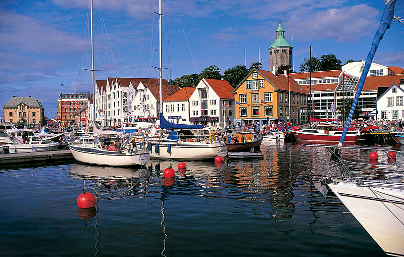
Old Stavanger (
Gamle Stavanger ) is located right next to the city centre and has a collection of eighteenth- and nineteenth century wooden structures.Stavanger domkirke (St. Svithun's cathedral) was built between 1100 and 1125 by the English bishop Reinald inAnglo-Norman style, and in the late 13th century a new choir was added in Gothic style, with a vaulted roof. Among the old stone churches in Norway, the cathedral in Stavanger is among the best preserved. POV-statement|date=December 2007The city centre itself is small and intimate, with narrow streets and open spaces protected from car traffic. The open-air vegetable market is one of the very few in Norway where you can buy produce directly from local farmers every working day through the year. Fact|date=June 2007
Museums
The
Stavanger Museum is also located in Old Stavanger, commemorating the city's past glory as theherring capital of Norway. [ [http://www.stavanger.museum.no/default.aspx?ChannelID=1114 Stavanger Museum ] ]The museum of
Archaelogy is one of five archaeological museums inNorway . According to the Museum itself it, "follows a profile of environmental archaeology and interdisciplinary study, with a scientific staff that includes representatives from archaeology, the natural sciences and modern cultural history."The
Norwegian Petroleum Museum is located at the harbour. The museum reflects the fact that Stavanger has been Norway's oil capital since oil drilling activities started in the North Sea in 1966. [ [http://www.norskolje.museum.no/hovedframe.htm Norsk Oljemuseum ] ]ister cities
Stavanger has several sister cities; they are:
*flagicon|ScotlandAberdeen ,Scotland [citeweb|url=http://www.aberdeencity.gov.uk/ACCI/web/site/Tourism/SL/tur_TownTwinning.asp|title=Twinning|publisher=Aberdeen City Council|accessdate=2008-03-02]
*flagicon|MadagascarAntsirabe ,Madagascar
*flagicon|DenmarkEsbjerg ,Denmark
*flagicon|SwedenEskilstuna ,Sweden
*flagicon|NicaraguaEsteli ,Nicaragua
*flagicon|Iceland Fjarðabyggð (previously known as Neskaupstaður),Iceland
*flagicon|US Galveston,United States
*flagicon|EnglandHarlow ,England
*flagicon|US Houston,United States
*flagicon|FinlandJyväskylä ,Finland
*flagicon|PalestineNablus ,West Bank
*flagicon|IsraelNetanya ,Israel
*flagicon|EritreaMassawa ,Eritrea References
External links
* [http://www.stavanger.kommune.no/ Municipality web site]
* [http://www.stavanger.kommune.no/publikum/news.nsf/SVGsokNyheter/7C60EDDFB77AC8B0C125738C004E409C?OpenDocument&id=7C60EDDFB77AC8B0C125738C004E409C&referer=0 Official City Maps]
* [http://www.stavanger-web.com/ Stavanger Web]
* [http://www.rkm.no/ Rogaland Museum Of Fine Arts]
* [http://www.maijazz.no Maijazz no icon]
* [http://www.icmf.no International Chamber Music Festival]
* [http://www.yr.no/stad/Noreg/Rogaland/Stavanger/Stavanger/ Weather forecast for Stavanger]
* [http://www.aftenbladet.no/english/ Latest News in English - Aftenbladet.no]
*wikitravel
Wikimedia Foundation. 2010.