- Hughes Mountain
-
 The Devil's Honeycomb, Hughes Mountain State Natural Area
 The Devil's Honeycomb, Hughes Mountain State Natural Area
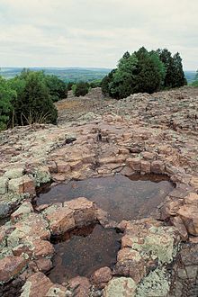 The Devil's Honeycomb, Hughes Mountain State Natural Area
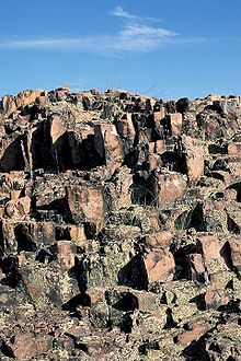 The Devil's Honeycomb, Hughes Mountain State Natural Area
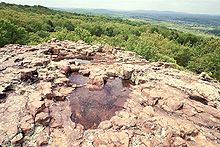
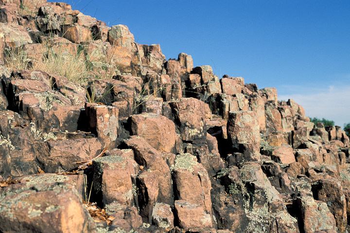
 Columnar jointing of rhyolite, Devil's Honeycomb, Hughes Mountain State Natural Area
Hughes Mountain and the Hughes Mountain State Natural Area are located in southern Washington County, Missouri (Sections 28 and 33, T36N R3E)[1] just south of the Big River and Highway M on Cedar Creek Road in the St. Francois Mountains range of The Ozarks. The mountain reaches an elevation of 1,201 feet[2] (366.06 m), rising 430 feet (131.06 m) above the Big River. The Hughes Mountain Natural Area of the Missouri Department of Conservation encompasses 462 acres (1.87 km2) of the mountain, including the rhyolite glade at its top.[3]
Contents
History
The area around Hughes Mountain was first settled ca 1810 by John Hughes,[4][5] his wife (Susannah) and their children, resulting in the mountain being named Hughes Mountain. The mountain itself remained public land until 1861 when purchased by John Hughes's son, Mahlon Hughes and afterwards remained in the Hughes family until it was purchased by the Missouri Conservation Commission in 1982. At that time it was designated a State Natural Area.[6]
Hughes Mountain State Natural Area
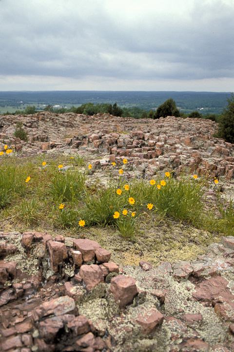
The Hughes Mountain State Natural Area can be accessed by the public via a 1.4 mile (2.253 kilometers) linear/loop trail with the trail head in a small parking area on Cedar Creek Road. Within the Hughes Mountain Natural Area is a glade with an outcrop of Precambrian columnar jointed rhyolite designated the Devil's Honeycomb. Devil's Honeycomb is listed in the book, Geographic Wonders and Curiosities of Missouri.[7] The natural area is divided between forest land (about 2/3 the total area) containing three types of forests, and glades(about 1/3 the total area).
Flora and fauna
The forest contains mainly post oaks, white oaks, stunted blackjack oaks, eastern red cedar, black hickory, farkleberry, winged elm, lowbush blueberry, service berry, red elm, sassafras, winged sumac and aromatic sumac. The glade flora includes rushfoil, rough buttonweed, broomsedge, poverty grass, yellow star grass, little bluestem, flame flowers, prickly pear cactus, spider wort, wild hyacinth, lance leaf coreopsis, pine-weed and a variety of lichen. Fauna species include two species of lizards, fence and collared, lichen grasshoppers, and prairie warblers.[6]
Geology
Hughes Mountain is a peak in the St. Francois Mountains Range of southeastern Missouri. These mountains formed 1.485 billion years ago during the Precambrian eon when the area was volcanically active.[8] Hughes Mountain is formed of intrusive rhyolite which broke into vertical joints when it cooled, creating polygonal columns. These columns have from four to six sides and are up to three feet (0.91 m) tall. When viewed from above they resemble a honeycomb. The Devils Honeycomb is a smaller example of the sort of columnar jointing found at Devils Tower National Monument in Wyoming, Devils Postpile National Monument in California, and the Giant's Causeway near Bushmills, Northern Ireland.
Location
Hughes Mountain State Natural Area's parking is located on Cedar Creek Road, 3 miles (4.8 km) southeast of Irondale on Highway M or 5-mile (8.0 km) easat/northeaston Highway M from Highway 21 at 37°48′03″N 90°42′29″W / 37.8007°N 90.708°WCoordinates: 37°48′03″N 90°42′29″W / 37.8007°N 90.708°W
Notes
- ^ "Missouri Department of Conservation; Directory Of Missouri Natural Areas; Hughes Mountain". http://mdc.mo.gov/areas/natareas/p146-1.htm. Retrieved 2009-04-16.
- ^ "Mountainzone.com; Hughes Mountain Summit". http://www.mountainzone.com/mountains/detail.asp?fid=6908756. Retrieved 2009-04-16.
- ^ "Hughes Mountain Natural Area Area Summary". Conservation Atlas. Missouri Department of Conservation. http://mdc4.mdc.mo.gov/applications/moatlas/AreaSummaryPage.aspx?txtAreaID=8252. Retrieved 2010-03-20.
- ^ "Missouri Department of Conservation; Conservation Atlas Area Summary; Hughes Mountain Natural Area". http://mdc4.mdc.mo.gov/applications/moatlas/AreaSummaryPage.aspx?txtAreaID=8252&txtUserID=guest. Retrieved 2009-04-16.
- ^ Thom, Richard (September 1987). written at Liberty, MO. Missouri Conservationist (Hughes Mountain Natural Area). V. 48, No. 8. Harmony Printing Co.. pp. 10–14. ISSN 0026-6515
- ^ a b Missouri Department of Conservation -- Missouri Dept. of Natural Resources, Natural Area Nomination Form 1982
- ^ Beveridge, Thomas Robinson (1978). Geologic Wonders and Curiosities of Missouri. pp. 10–18.
- ^ Denison, Rodger E., et al., Geology and Geochemistry of the Precambrian Rocks in the Central Interior Region of the United States, Geological Survey Professional Paper 1241-C, 1984
References
- Missouri Department of Conservation—Missouri Dept. of Natural Resources, Natural Area Nomination Form 1982
- Geologic Wonders and Curiosities of Missouri, By Thomas Robinson Beveridge, Missouri Division of Geology and Land Survey, 1978, pgs 18-20
- The Missouri Conservationist, Vol. 48 No. 8 September 1987, pgs 10-14, article by Richard Thom
- "Missouri Department of Conservation Brochure" (PDF). USDA Forest Service. http://mdc.mo.gov/documents/area_brochures/8252.pdf. Retrieved April 16, 2009.[dead link]
- "Missouri Department of Conservation Area Summary". USDA Forest Service. http://mdc4.mdc.mo.gov/applications/moatlas/AreaSummaryPage.aspx?txtAreaID=8252&txtUserID=guest. Retrieved April 16, 2009.
External links
- "Missouri Department of Conservation Map" (PDF). USDA Forest Service. http://mdc.mo.gov/documents/area_brochures/8252map.pdf. Retrieved April 16, 2009.[dead link]
- "Missouri Hiking Photos Site". http://www.mohiking.com/gallery2/main.php?g2_view=core.ShowItem&g2_itemId=1253. Retrieved April 16 accessyear=2009.
- "Southeast Missourian Article". http://www.semissourian.com/blogs/pavementends/entry/24002. Retrieved April 16, 2009.
- "(4-H Youth) Missouri Hiking Trail". http://extension.missouri.edu/stfrancois/4-H%20Youth/hiking/hughes.htm. Retrieved April 16, 2009.
 Panoramic view from atop Hughes Mountain
 Categories:
- St. Francois Mountains
- Mountains of Missouri
- Protected areas established in 1982
- Rock formations in Missouri
- Geography of Washington County, Missouri
- Intrusions


Wikimedia Foundation. 2010.