- Woodcroft Halt railway station
-
Woodcroft Halt Location Place Chalton Area East Hampshire Coordinates 50°56′22″N 0°57′05″W / 50.9395°N 0.9514°WCoordinates: 50°56′22″N 0°57′05″W / 50.9395°N 0.9514°W Grid reference SU737161 Operations Original company Southern Railway Post-grouping Southern Railway History 4 October 1943 Station opened 1 October 1945 Station closed Disused railway stations in the United Kingdom Closed railway stations in Britain
A B C D–F G H–J K–L M–O P–R S T–V W–Z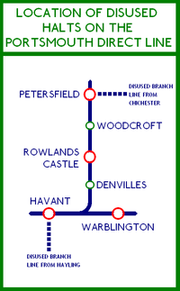
Woodcroft Halt railway station was a former railway halt located in the parish of Buriton between Rowlands Castle and Petersfield on the Portsmouth Direct Line.
Contents
History
During World War II, in 1940 the Admiralty requisitioned Ditcham Park, a nearby country house for use as a convalescent home for sailors (the house is now a private school). The halt was built to serve Ditcham Park, principally for trains from the extensive naval facilities in Portsmouth about 20 km (12 mi) away. Woodcroft Halt, which was also known as Ditcham Park Halt, opened on 4 October 1943, and closed on 1 October 1945.[1]
Because of its naval nature, it was featured on few maps, but some maps did mark it by a little tab without a name.
It was closed in 1945 and subsequently demolished. Today, only a footbridge remains.
Location
The halt was located 59 miles 72 chains (96.4 km) from Waterloo,[2] at grid reference SU737161[1] which is now marked on the OS 1:25000 map as "Woodcroft Farm". The stations to either side were Petersfield and Rowlands Castle.[1]
Preceding station Historical railways Following station Petersfield
Line and station openSouthern Railway
Portsmouth Direct LineRowlands Castle
Line and station openNotes
- ^ a b c Croughton, Godfrey; Kidner, R.W.; Young, Alan (1982). Private and Untimetabled Railway Stations. Salisbury: Oakwood Press. p. 142. ISBN 0 85361 281 1.
- ^ Yonge, John (November 2008) [1994]. Jacobs, Gerald. ed. Railway Track Diagrams 5: Southern & TfL (3rd ed.). Bradford on Avon: Trackmaps. map 26B. ISBN 978 0 9549866 4 3.
References
- Mitchell, Vic; Smith, Keith (December 1985). Woking to Portsmouth (Southern Main Line Railway Albums). Middleton Press. fig. 96. ISBN 0-906520-25-8.
External links
- Information sheet about Ditcham on the Buriton website. Note the "ladies" brought in every Thursday night.
- Ralph W. Hill's war time memories
- Picture of Ditcham Park School at Geograph
- Location of Woodcroft Halt on navigable 1946 O.S. map
Closed railway stations in Hampshire Didcot, Newbury and Southampton Railway Woodhay · Highclere · Burghclere · Litchfield · Whitchurch · Barton Stacey · Sutton Scotney · Worthy Down · King's Worthy · Winchester (Chesil)Basingstoke and Alton Light Railway Meon Valley Railway Sprat and Winkle Line
Fullerton to Hurstbourne LineAndover Town · Clatford · Fullerton Junction · Stockbridge · Horsebridge · Mottisfont · Longparish · WherwellFawley Branch Line Lymington Branch Line Shirley Holms Halt · Ampress Works HaltSouthampton and Dorchester Railway Hayling Island Branch Line Fareham to Gosport Line Fort Brockhurst · GosportLee-on-the-Solent Branch Line Fort Gomer Halt · Browndown Halt · Elmore Halt · Lee-on-the-SolentStokes Bay Line Gosport Road and Alverstone · Stokes BaySouthsea Railway Bordon Light Railway West of England Main Line Salisbury and Dorset Junction Railway Other stations Basingstoke · Bishops Waltham · Denvilles halt · Durley Halt · Farlington Halt · Itchen Abbas · Knowle Halt · Northam · Nursling · Paulsgrove Halt · Southampton Terminus · Weyhill · Woodcroft HaltStations in Dorset since 1974Ringwood, Christchurch and Bournemouth Railway Southampton and Dorchester Railway Categories:- Disused railway stations in Hampshire
- Former Southern Railway stations
- Railway stations opened in 1943
- Railway stations closed in 1945
- South East England railway station stubs

Wikimedia Foundation. 2010.