- Dock Square (Boston, Massachusetts)
-

Dock Square in Boston, Massachusetts is a public square adjacent to Faneuil Hall, bounded by Congress Street, North Street, and Union Street.[1] Its name derives from its original (17th-century) location at the waterfront. From the 1630s through the early 19th-century, it served boats in the Boston Harbor as "the common landing place, at Bendell's Cove," later called Town Dock.[2] "Around the dock was transacted the chief mercantile business of the town."[3] After the waterfront was filled in in the early 19th-century, Dock Square continued as a center of commerce for some years. The addition in the 1960s of Government Center changed the scale and character of the square from a hub of city life, to a place one merely passes through.[4] As of the 1950s the square has become largely a tourist spot; the Freedom Trail runs through it.
Contents
History
17th-19th centuries
- Market versus anti-market
 Detail of map of Boston showing Bendell's Cove in 1635 (which later became Town Dock and Dock Square, ca.1708)[5]
For much of its long history, Dock Square has been a center of commerce in Boston. In the 17th and 18th centuries vendors would sell their wares (butter, fish, etc.) in the open, or from stalls. In 1733 a public market building opened, to some controversy (opponents disliked regulation). A few years later, anti-market sentiment had reached a boiling point: "in 1737 a mob disguised as clergymen turned out one wintry night ... and completely demolished the market house in Dock Square."[6] In 1742 Faneuil Hall opened, again with mixed support. "Town records abound with complaints that Dock Square and other areas near Faneuil Hall were cluttered with carts and market paraphernalia, the market people apparently preferring standing outside the market to paying for a stall inside it and submitting to its other regulations." By 1764, it was illegal for vendors to place "'any horse, cart, carriage, stall, stand, bench, block, provisions or incumbrance in or upon ... Dock Square'" and "townspeople were urged not to buy from persons selling in Dock Square or nearby streets."[7]
- Slave trade
Although sad to report, buying and selling of slaves took place in Dock Square (and elsewhere in town), for instance by "Capt. Thomas Smith, Dock Square, slave boy at 14" in 1717;[8] and in the Sun Tavern in 1727: "On Thursday ... will be sold by publick vendue at the Sun Tavern on Dock Square at five a clock p.m. Four likely negros, and sundry sort of merchandize, all to be seen at the place of sale from two of the clock till the sale begins."[9]
- Shops
Numerous shops and businesses have come and gone at Dock Square. One typical 1723 newspaper advertisement declares: "Just arrived from London and to be sold by Mr. John Williams at his ware-house, next door to the Golden-Ball, on Dock Square, Boston, choice Bohea tea, at twenty shilling per pound, and very good Cheshire cheese; as also sundry other sorts of European goods."[10] In 1789, tenants in the square included innholder Mrs. Baker (at the "sign of the Punch-bowl"); dry-goods dealer John Brazer; grocer William Saxton. In 1805: E. Bonnemort's snuff shop; ship chandler Samuel Browning; innkeeper Elijah Dagget; druggist Eliakim Morse; hardware dealers John Odin and William Whitwell; Aaron Richardson's feather-store; auctioneer Benjamin Tucker; cardmakers William Whittemore & Co.[11] In the early 19th century, Samuel Eliot, (father of future mayor Samuel Eliot) ran "what might today be called a department store in Dock Square. He dealt in everything from diapers to tombstones."[12]
20th-21st centuries
In the middle of the 20th century the square and environs became increasingly surrounded by automotive traffic and tall buildings.[13] A large highway (I-93) was constructed nearby (although the Big Dig sunk the highway underground by 2007). In the 1960s some of the smaller streets and pedestrian passageways were demolished — including Brattle Street and Cornhill, abutting Dock Square — to make way for the construction of the large-scale, brutalist Boston City Hall and similar structures in the Government Center complex.[14]
Image gallery
-

Savage house, 30 Dock Sq., built early 18th c., demolished 1926
-

Dock Sq. and Town Dock, 1738
-

Detail of 1743 map of Boston, showing Town Dock and Dock Square
-

Sun Tavern, Dock Sq., ca.17th-18th c.
-
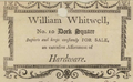
Advertisement for William Whitwell's hardware shop, ca.1803
-

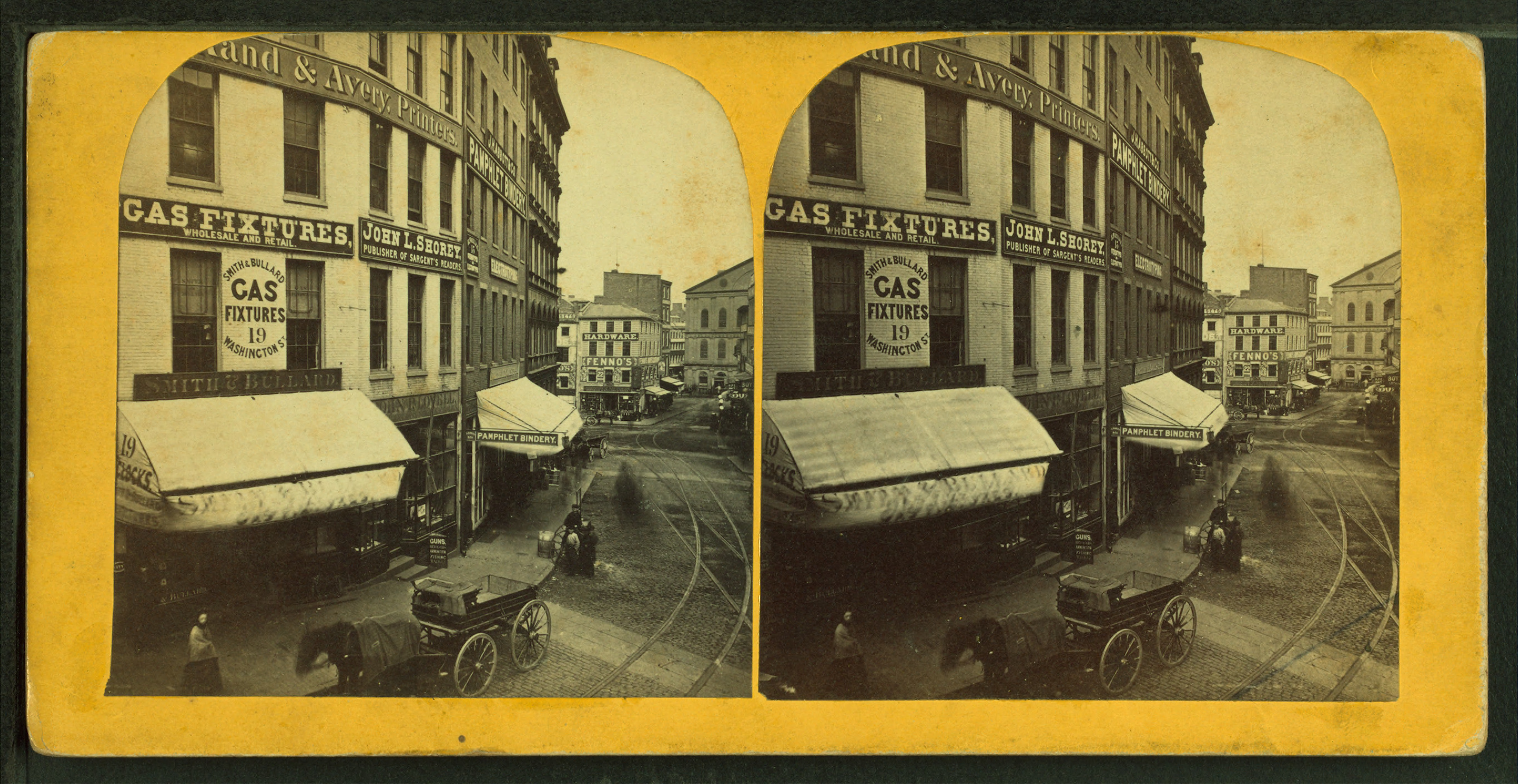
Dock Sq. and Washington St., ca.1860s
-

Advertisement for Lovell's gun shop, 1861
-

View of Dock Sq., Faneuil Hall (at right), 19th c.
-

Dock Square, including Sun Tavern, ca.1898
-

Dock Square, 1920
-

Dock Square, with view of Faneuil Hall, Boston, 1987
-

Dock Square and Congress St., 2010, with view of Anne Whitney's statue of Samuel Adams
See also
- Faneuil Hall, built 1742
- Old Feather Store (1680–1860)
- Anne Whitney, sculptor of Sam Adams statue (1880) in Dock Sq.
References
- ^ http://www.cityofboston.gov/publicworks/streetbook
- ^ Walter Kendall Watkins. The great street to Roxbury Gate, 1630-1830. Bostonian Society Publications, 1919.
- ^ Boston Street Laying-Out Dept. A record of the streets, alleys, places, etc. in the city of Boston. Boston: City Printing Dept., 1910.
- ^ Robert Campbell and Peter Vanderwarker. Dock Square. Boston Globe, Oct 5, 1997. pg. 18.
- ^ A record of the streets, alleys, places, etc. in the city of Boston. 1910
- ^ G. B. Warden. The Caucus and Democracy in Colonial Boston. New England Quarterly, Vol. 43, No. 1 (Mar., 1970); p.31.
- ^ Karen J. Friedmann. Victualling Colonial Boston. Agricultural History, Vol. 47, No. 3 (Jul., 1973); p.203-204.
- ^ Boston News-Letter, Dec. 23, 1717; quoted in: Nian-Sheng Huang. Franklin's Father Josiah: Life of a Colonial Boston Tallow Chandler, 1657-1745. Transactions of the American Philosophical Society, New Series, Vol. 90, No. 3 (2000); p.61.
- ^ Boston Gazette, Nov. 20-27, 1727; quoted in: Robert E. Desrochers, Jr. Slave-for-Sale Advertisements and Slavery in Massachusetts, 1704-1781. William and Mary Quarterly, Third Series, Vol. 59, No. 3, Slaveries in the Atlantic World (Jul., 2002); p.627.
- ^ Boston News-Letter, May 23–30, 1723.
- ^ Boston Directory. 1789, 1805.
- ^ Samuel A. Eliot. Being Mayor of Boston a Hundred Years Ago. Proceedings of the Massachusetts Historical Society, Third Series, Vol. 66 (Oct., 1936 -May, 1941), pp. 154-173.
- ^ Campbell and Vanderwarker. Boston Globe, Oct 5, 1997.
- ^ Whitehill and Kennedy. Boston: A Topographical History, 3rd ed. Cambridge, Massachusetts: Belknap Press, 2000.
Further reading
- Thomas Tileston Waterman, "The Savage House, Dock Square, Boston, Mass.," Old Time New England 17, no. 3 (January 1927).
- Robert Campbell and Peter Vanderwarker. Dock Square. Boston Globe, Oct 5, 1997. pg. 18.
External links
- Bostonian Society has materials related to the square.
- Boston Public Library. A draught of Boston Harbor by Capt. Cyprian Southake. 1694 map, showing "Dock."
- Google News Archive. Articles related to Dock Sq., Boston
Categories:- Squares in Boston, Massachusetts
- History of Boston, Massachusetts
- Financial District, Boston
- Freedom Trail
- Government Center, Boston


Wikimedia Foundation. 2010.