- Parkwoods
-
Parkwoods — Neighbourhood — 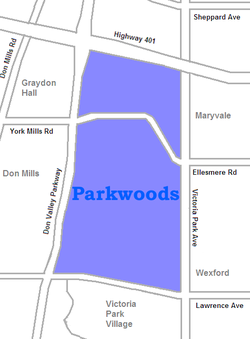
Country  Canada
Province  Ontario
City  Toronto
Parkwoods is a neighbourhood in the city of Toronto, located just south of the 401, West of Victoria Park Ave, North of Lawrence and east of the Don Valley.
The neighbourhood is popular with new immigrants to the city and has a mix of lower income and middle income families. As a result there is a huge number of visible minorities (over 50%). Chinese, South Asians and Blacks make up the largest percentage of ancestries in the area, after Canadian and other mixes.
In the North West quadrant of the neighbourhood is the area known as Graydon, which is built up on hillside terrains and is home to the Donalda Golf course.
Schools
Donview Middle School is a middle school with grades from 6 to 8, in the Toronto District School Board. The current school principal is Mrs. Susan Brown, and the vice-principal is Mr. Neel Vohra. The school is located on Evermede Drive. The school currently has about 500 students. Students from Roywood Public School, Fenside Public School, Three Valleys Public School and Rene Gordon Elementary School attend Donview when they are ready for grade 6. Most of the students go to George S. Henry Academy, Victoria Park Collegiate Institute or Senator O'Connor College School after graduating from Grade 8. Donview Middle School was once called Donview Heights Junior High School, when it first opened.
Milne Valley Middle School is a middle school on Underhill Drive, near Lawrence Ave. E. and Highway 401. The school is for students in grade 6, 7, and 8. The students of the school usually graduate and continue their secondary education in Victoria Park Collegiate Institute, George S. Henry Academy, Don Mills Collegiate Institute, or Wexford Collegiate. The current principal of Milne Valley Middle School is Mrs. Maria Campbell, who was the previous vice-principal of Donview Middle School, and the vice principal is Mr. Ian Wilson. Milne Valley Middle School used to be Milneford Junior High School before.
Fenside Public School is an elementary school on Fenside Drive near York Mills Road. The school is for JK-Gr.5.
Three Valleys Public School is an elementary school on Three Valleys Drive near the DVP. The school is for JK-Gr.5. The current principal is Ms. Melissa Carson. Graduates will either go to Milne Valley or Donview.
Roywood Public School is an elementary school located at 11 Roywood Drive, which is close to York Mills Road and Victoria Park Avenue. The school is for JK-Gr.5. The current principal is Mrs. A. Johnson. Most Graduates will go to Donview.
Cassandra Public School is an elementary school located at 45 Cassandra Boulevard.
Ranchdale Public School is an elementary school located south of York Mills Road and west of Victoria Park Avenue. The school is for JK-Gr.5.
Victoria Park Collegiate Institute is a high school located at 15 Wallingford Road.
Crestwood Preparatory College is a high school located at 217 Brookbanks Drive. The school was founded in 2001 and runs from Gr.7 - Gr.12.
External links

Henry Farm, Tam O'Shanter-Sullivan Graydon Hall, Don Mills 
Maryvale, Wexford  Parkwoods

Victoria Park Village Categories:- Neighbourhoods in Toronto

Wikimedia Foundation. 2010.