- Doohoma
-
Doohoma
Dubh Thúama— Town — Location in Ireland
 Doohoma
Coordinates: 54°03′52″N 9°32′09″W / 54.0645°N 9.5357°WCoordinates: 54°03′52″N 9°32′09″W / 54.0645°N 9.5357°W Country Ireland Province Connacht County County Mayo Time zone WET (UTC+0) - Summer (DST) IST (WEST) (UTC-1) Irish Grid Reference F Contents
General Description
Doohoma', (Irish: Dubh Thuama meaning "black tomb") is named after the mass grave situated in the sand dunes in close proximity to the sea. This was as a result of the great Great Famine of 1845.
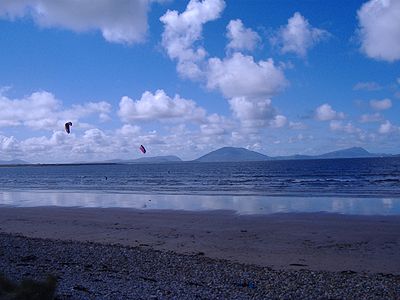
Doohoma is situated on the north-west coast of Kiltane parish, Erris, County Mayo and is a peninsula on the Atlantic coastline. Its area consists of 1,102 acres (4.46 km2), none of it any distance from its beautiful coastline without crowds or pollution. It is situated approx. fifteen miles (24 km) south west of the village of Bangor Erris. It overlooks Achill Island and the Mullet Peninsula. It is a picturesque village with panoramic sea views across Blacksod Bay. Its long sandy beaches and safe bays are perfect for watersports such as surfing, kiting, sailing, swimming, fishing, boating and wind surfing.
Doohoma is the central village and collective name for a further six villages, which include Doohoma Head (Cean Romhar), Crook na Mona, Bunnafully, Tallaghan, Roy Carter and Roy Bingham.[1] There are two pubs, The Sea Rod Inn (Barrett's) and Tra Bui (Holmes's), a post office and two grocery stores.[1]
There are two strong community focal points in Doohoma, namely the local Roman Catholic church (Pope Pius X) and the Doohoma National School. As well as educating the local children, the National School also supplies the Kiltane Gaelic Football Club with players. There is also an 18 hole golf course.
The town-land was the theme of the RTE documentary 'Doohoma'which dealt with the theme of emigration to England and the effect on local families. In recent years, however, a number of first and second-generation natives have returned to take advantage of the improving economic climate. [2] [3] Modern technology has allowed those who emigrated to keep in touch with their old friends from Doohoma all around the world. There are many groups on facebook such as Are you from or been to Erris Co.Mayo Ireland? Photographs and stories can be shared and family trees completed.
History
Like many other parts of County Mayo, Doohoma was devastated during the famine years of the mid 1840's. The population of 455 people in 1841 was more than halved to 218 people by 1851.[2] It has endured high levels of emigration throughout the years, with the diaspora of Doohoma spreading across the world to such countries as England, Scotland, USA, Australia and Canada. Despite the geographical distance, these emigrants have kept strong links with the area. The first main road through the townland was not built until 1847.
After the famine, mass burials took place on the sandbanks and, despite repeated requests by local people grew louder for a proper cemetery, a request repeatedly rejected by the civil authorities. Eventually, in 1926 three hundred local men erected a sod wall, which was later consecrated by Bishop James Naughton. Eventually Mayo County Council granted some money to erect a stone wall to replace the sod ditch. Later local residents were unsuccessful in their endeavours to get a road built from the sandbanks to the cemetery, so in 1967 over 100 volunteers built a road to improve access. In 1989 the Council tarred the road for the first time.
Doohoma had a long history of emigration. Fishing was the main occupation of the community but was never able to sustain the growing population entirely so every year in June whole families would go to the potato fields of Scotland. These workers were known as "tattie hokers". There were so many went from Doohoma that ships would moor off Doohoma Head to transport them to the potato fields of Scotland.
The first National School was established in Doohoma in 1859 just outside the boundary of the Tallaghanbawn townland and the first church in the townland was built close by later.
A new industry was opened in the early 1970s - Eagle Isle Seafoods founded in 1972 exports smoked wild Atlantic salmon all over the world.
In 1987, Mayo County Council financed a two million pound water scheme. This brought piped water from Carrowmorw Lake, a much needed boost to the local infrastructure.
In the past, the village survived primarily on small farming and fishing communities, but in recent years the occupations of the residents vary.
Sports
Doohoma has a football tradition
It also has produced some boxers
References
- ^ http://www.thesearodinn.ie/About/About.htm
- ^ Noone, Fr. Sean. Where the Sun Sets (1991) Naas
See also
Categories:- Untranslated Irish place names
- County Mayo
- Towns and villages in County Mayo


Wikimedia Foundation. 2010.