- Parque Urbano Dora Colón Clavell
-
Parque Urbano Dora Colón Clavell
(Dora Colón Clavell Urban Park)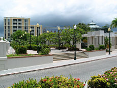
The Dora Colon Clavell Urban Park, looking north in Barrio Primero in Ponce, Puerto RicoType Passive park Location Marina and Jobos Streets, Barrio Primero, in Ponce, Puerto Rico Area approx 4 cuerdas Created 1995 Operated by Autonomous Municipality of Ponce Open Every day The Parque Urbano Dora Colón Clavell (English: Dora Colón Clavell Urban Park) is a passive park in Ponce, Puerto Rico.[1] The park is named after the mother of ex-governor of Puerto Rico and Ponce native, Rafael Hernández Colón.[2]
Contents
Location
The park is a passive urban family park. It is located in Ponce's Historical District, near a number of museums and parks, including the Ponce Massacre Museum and the Abolition Park. It features a number of kiosks (that are currently not in use) and a central stage where the Ponce Municipal band stages free open-air concerts.[3]
History
The park was built in 1995 under the administration of mayor Churumba and, in the same year, it received the award for Outstanding Construction Work of the Year (Spanish: "Obra Sobresaliente del Año") from the College of Engineers and Surveyors of Puerto Rico. [4]
Amenities
The park has a handy underground parking garage.[5] It also features gardens, a Mudéjar-style kiosk for the Ponce Municipal Band traditional Sunday concerts, a trolley stop, a restaurant, and food stands.[6]
There is a convenient underground parking garage at the park. The parking garage has two levels. In the first (top-most) level of the garage there is a Ponce tourist police station.
References
- ^ Photo and location of Dora Colon Clavell Park in Panoramio.com
- ^ Explore Puerto Rico. By Harry S. Pariser. Page 240.
- ^ Dora Colón Clavell Urban Park. Let'sGoToPonce.com Retrieved April 25, 2010.
- ^ Act No. 256 (H. B. 2988) of the 7th Session of the 15th Legislature of Puerto Rico. Retrieved April 25, 2010
- ^ Free Municipal Parking Lot. LetsGo: Destinations, Ponce. Retrieved April 25, 2010.
- ^ Plaza Del Caribe Tourism information. Retrieved April 25, 2010.
Coordinates: 18°00′29.15″N 66°36′50.04″W / 18.0080972°N 66.6139°W
Categories:- Buildings and structures in Ponce, Puerto Rico
- Visitor attractions in Puerto Rico
- Urban public parks
- Ponce, Puerto Rico
- Parks in Ponce, Puerto Rico

Wikimedia Foundation. 2010.