- Douglas Harbour
-
For the Alaskan harbor, see Douglas Harbor.
Douglas Harbour 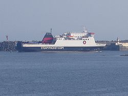
Douglas Location Country Isle of Man Location Douglas Coordinates 54°8′48.2″N 4°28′2.5″W / 54.146722°N 4.467361°WCoordinates: 54°8′48.2″N 4°28′2.5″W / 54.146722°N 4.467361°W Details Opened 1660 Operated by Isle of Man Government Owned by Isle of Man Available berths 16 Piers 4 Port Manager Captain John Clayton Statistics Passenger traffic 635,269 (2008) Website IoM Gov't Harbours Division  Vehicle assembly area and passenger bridge near Edward Pier.
Douglas Harbour is located near Douglas Head on the southern end of Douglas, the capital town of Isle of Man. It is the island's primary commercial shipping port.
Contents
Description
 Sea Terminal & Harbour Control Building in Douglas.
Douglas Harbour is composed of the Outer Harbour and the Inner Harbour separated by the Bascule Bridge and Flapgate. A sea terminal building is located on the northeast end of the harbour co-located with the harbour control.[1]
The Outer Harbour features two jetties, four piers, eleven berths, and an area designated for lifeboats.[1] The piers are:
- Alexandra Pier
- Battery Pier
- Edward Pier
- Victoria Pier
The two jetties are:
- Fort Anne Jetty
- Oil Jetty
The Inner Harbour allows access and berthing of small vessels.[1]
Traffic
By tonnage, the port's primary traffic is from the Isle of Man Steam Packet Company fleet.
In the vicinity of the Sea Terminal are the following stations/stops which facilitate passenger transport connections:
- Bus Vannin - Lord Street (A1) Depot (Stands A - E) near Parade Street (A11), serves most bus routes[2]
- Bus Vannin - Loch Promenade Stop (Stands F, G) near Regent Street, serves Ramsey and intra-Douglas routes[2]
- Isle of Man Steam Railway - Douglas Railway Station on Bank Hill near Lord (A1) and Athol (A22) Streets.
- Douglas Bay Horse Tramway - Loch Promenade near Victoria Pier
By connecting with the appropriate bus or tramway, sea passengers may also transfer to the Manx Electric Railway to points north.
History
The earliest recorded history indicating the presence of infrastructure facilitating the use of Douglas Harbour dates back to 1660.[3]
Hazards
 St. Mary's Isle in Douglas Bay as seen from the Loch Promenade.
Connister Rock, also known as St Mary's Isle, is a small islet which becomes completely submerged during high tides and removed from sight during stormy, night, or other low visibility conditions. As such, the isle has laid claim to many shipwrecks until the Tower of Refuge was built.[4]
See also
- RNLI
References
- ^ a b c "New Douglas Harbour Map". Douglas Harbour. Isle of Man Government Harbours Division. 2009. http://www.gov.im/transport/harbours/ports/Image.gov?id=5888. Retrieved 24 August 2009.
- ^ a b Department of Tourism & Leisure (2008). "Douglas Depot". Isle of Man Government. http://www.iombusandrail.info/depots-douglas.html. Retrieved 26 August 2009.[dead link]
- ^ "Notable Events 1650 - 1796". Isle of Man Harbour History. Isle of Man Government. 2009. http://www.gov.im/transport/harbours/history.xml. Retrieved 23 August 2009.
- ^ "St Mary's Isle (Conister Rocks or Tower of Refuge)". isleofman.com Community. Isleofman Dot Com Ltd. 2006. http://www.isleofman.com/Community/ePedia/Geography/Islands/StMarysIsle.aspx. Retrieved 26 August 2009.[dead link]
External links
Categories:- Douglas, Isle of Man
- Islands of the Irish Sea


Wikimedia Foundation. 2010.