- Dovercourt Park
-
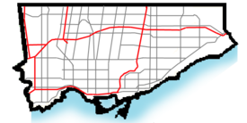
Dovercourt Park — Neighbourhood — 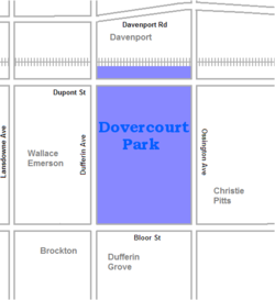 Location of Dovercourt Park in Toronto
Country  Canada
Province  Ontario
City  Toronto
Government – City Councillor Cesar Palacio
Adam Giambrone
Joe Pantalone– Federal M.P. Mario Silva
Olivia Chow– Provincial M.P.P. Tony Ruprecht
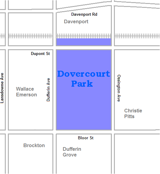
Rosario MarcheseDovercourt Park is a neighbourhood in Toronto, Ontario, Canada situated north of Bloor Street between Christie Street to the east, the CPR railway lines to the north, Dufferin Street to the west.
Contents
History
The Village of Dovercourt was founded in the 1870s. Its residents were originally poor immigrants from England living in dozens of one and two bedroom tar and paper shacks which initially resulted in the village being called a shantytown.
The village was annexed by the old City of Toronto in 1912 resulting in city services being extended to the neighbourhood helping stimulate its growth and development by 1923.[1]
The name Dovercourt comes from the name of the home of the Denison estate, located west of Dundas and Ossington.
Character
The neighbourhood contains a mixture of land-uses. The main thoroughfare of Bloor Street consists almost exclusively of mixed-use residential and commercial buildings. The Bloorcourt Village BIA posts its streetlamp banners on Bloor between Dufferin and Montrose.
The buildings along Bloor Street are typically two or three stories tall, with retail commercial on the main floor, and offices or rental housing on the remainder. These converted residential structures are the oldest in the district and are often in poor repair. Pigeon infestation remains an issue for tenants. At Dovercourt Road, a large, high-rise apartment complex houses lower-middle-income tenants on the southwest corner.
Businesses on Dovercourt and Hallam, centred around the intersection of Dovercourt Road and Hallam Street have formed their own BIA, the 'Dovercourt Village'. The boundaries stretch from Dupont south to Shanley and east-west from Salem to Ossington Avenue.
The residential area north of Bloor Street is primarily single-family dwellings. Many of these structures have been converted into apartments, housing up to eight separate units. Side-streets increase in zoned density as they approach Bloor. Low and medium-rise apartments occupy the majority of these zones.
To the north, between Dupont and Davenport, is mainly post-industrial development. Limited manufacturing remains, although some warehouse and light automotive industries still exist. While the Canadian Pacific Railway operates a main line between the two thoroughfares, a large amount of former industrial space has been converted to loft condominiums. Some single-family rowhouses and low-income rental space has also been created.
The Bloor-Gladstone branch of the Toronto Public Library, dating from 1912, is situated at Bloor and Gladstone Avenue, one block east of Dufferin Avenue. From 2006 to 2009 the library was closed for renovation. It reopened to the public on July 23, 2009.[2]
Schools
- Dovercourt Junior Public School is a public elementary school on Bartlett Avenue, north of Hallam.
- Essex Public School is a public elementary school and middle school on Essex Street, east of Shaw.
- Pauline Public School is a public elementary school on Pauline Avenue, north-west of Bloor and Dufferin.
Demographics
For city demographics purposes the area is amalgamated with neighbouring areas to form Dovercourt-Wallace Emerson-Junction It is an ethnically diverse area. A majority of residents are fluent in Portuguese, Italian and English. A large Ethiopian population is also present in the area. There are many shops along Bloor Street serving the Portuguese and Ethiopian communities.
In the 2006 Canadian census Dovercourt Park was covered by census tracts 0095.00 and 0096.00. According to that census, the neighbourhood has 8,497 residents, a 9.2% decrease from the 2001 census. Average income is $28,311, below the average for Toronto. The ten most common language native languages, after English, are:
- Portuguese - 13.1%
- Unspecified Chinese - 3.5%
- Spanish - 3.5%
- Italian - 3.4%
- Cantonese - 2.8%
- Greek - 1.5%
- Mandarin - 1.5%
- Vietnamese - 1.0%
- French - 0.8%
- Urdu - 0.7%
Transportation
Lansdowne, Ossington and Dufferin stations on the Bloor–Danforth line serve the neighbourhood. The Dufferin bus runs north-south from Dufferin station and the Ossington and Rogers Road bus lines run north from Ossington station.
See also
References
External links

Corso Italia, Wychwood Park Wallace Emerson 
Seaton Village  Dovercourt Park

Bloordale Village Bloorcourt Village, Dufferin Grove Palmerston-Little Italy Former municipalities of Toronto by year of amalgamation 1883-1912 1883: Yorkville · 1884: Brockton · Riverdale · 1888: Seaton Village · 1889: Parkdale · 1890: Bedford Park · Davisville · 1905: Rosedale · 1908: Deer Park · East Toronto · 1909: Bracondale · West Toronto · Wychwood · 1910: Moore Park · North Toronto · 1912: Dovercourt · Earlscourt1967 1998 Categories:- Neighbourhoods in Toronto

Wikimedia Foundation. 2010.