Drumburgh

Drumburgh

Coordinates: 54°55′N 3°09′W / 54.92°N 3.15°W / 54.92; -03.15

Drumburgh
Eastern end of Drumburgh Village - geograph.org.uk - 912716.jpg
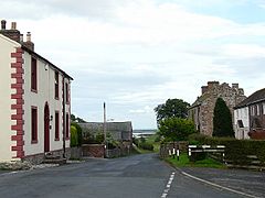
Drumburgh village, looking east
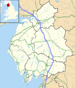
Drumburgh is located in Cumbria
Drumburgh

 Drumburgh shown within Cumbria
OS grid reference NY2659
Shire county Cumbria
Region North West
Country England
Sovereign state United Kingdom
Police Cumbria
Fire Cumbria
Ambulance North West
EU Parliament North West England
List of places: UK • England • Cumbria

Drumburgh is a small settlement in Cumbria, England. It is 13 kilometres (8 mi) northwest of the City of Carlisle and is on the course of Hadrian's Wall.

It was the site of the Roman fort of Coggabata. In the 14th century a tower house known as Drumburgh Castle was built here. It was rebuilt as a fortified farmhouse in 1518. It has extremely thick walls built with stone from Hadrian's Wall.

External links

Media related to Drumburgh at Wikimedia Commons


Wikimedia Foundation. 2010.

Игры ⚽ Нужен реферат?

Look at other dictionaries:

  • Drumburgh Castle — Cumbria, England Drumburgh Castle today …   Wikipedia

  • Coggabata — Coordinates: 54°55′37″N 3°08′53″W / 54.927°N 3.148°W / 54.927; 3.148 …   Wikipedia

  • Hadrian's Wall — This article is about the fortification in Northern England. For the Broad Wall of Jerusalem, see Broad Wall (Jerusalem). Coordinates: 55°01′27″N 2°17′33″W / 55.02417°N 2 …   Wikipedia

  • Hadrianswall — hf Hadrianswall Alternativname vallum aelium Limes Britannien Datierung (Belegung) 2. bis 5. Jahrhundert n. Chr. Typ Sperrwerk mit Zwischentürmen, Meilenkastellen und Grabensystem …   Deutsch Wikipedia

  • Cohors II Lingonum equitata — Activa Desde 73 hasta principios del siglo V. País Imperio romano Tipo …   Wikipedia Español

  • National Nature Reserves in Cumbria — National Nature Reserves in England were established by English Nature, now Natural England, which manages them either directly or by non governmental organisations such as the Royal Society for the Protection of Birds or the National Trust.… …   Wikipedia

  • List of places in Cumbria — This is a list of cities, towns and villages in the county of Cumbria, England. See the list of places in England for places in other counties.compactTOC NOTOC A*Abbey Town, Above Derwent, Ackenthwaite, Adgarley, Aglionby *Aiketgate, Aikhead,… …   Wikipedia

  • List of Sites of Special Scientific Interest in Cumbria — This is a list of the Sites of Special Scientific Interest (SSSIs) in Cumbria. For other counties, see List of SSSIs by Area of Search.* Alston Shingle Banks * Annaside * Annaside And Gutterby Banks * Appleby Fells * Argill Woods And Pastures *… …   Wikipedia

  • Silloth railway station — Silloth was the terminus of a branch railway from Carlisle.It was closed by the Beeching axe in 1964.The Allerdale council in northern England passed its final approval on a plan to demolish the remaining structure of the station on 2006 12 08.… …   Wikipedia

  • Rudge Cup — The Rudge Cup is a small enamelled bronze cup found in 1725 at Rudge, in Wiltshire. The cup was found down a well on the site of a Roman villa. It is important in that it lists five of the forts on the western section of Hadrian s Wall, thus… …   Wikipedia

Share the article and excerpts

Direct link
Do a right-click on the link above
and select “Copy Link”