- Dubreuilville
-
Dubreuilville — Township — 
 Dubreuilville
Coordinates: 48°21′N 84°33′W / 48.35°N 84.55°WCoordinates: 48°21′N 84°33′W / 48.35°N 84.55°W Country  Canada
Province  Ontario
District Algoma Established 1961 Incorporated 1977 Government - Type Township - Mayor Louise Perrier - Federal riding Algoma—Manitoulin—Kapuskasing - Prov. riding Algoma—Manitoulin Area[1] - Land 89.57 km2 (34.6 sq mi) Population (2006)[1] - Total 773 - Density 8.6/km2 (22.3/sq mi) Time zone EST (UTC-5) - Summer (DST) EDT (UTC-4) Postal Code P0S 1B0 Area code(s) 705 (884 exchange) Website www.dubreuilville.ca Dubreuilville is a township in the Canadian province of Ontario, located in the Algoma District. Established as a company town in 1961 by the Dubreuil Brothers lumber company, Dubreuilville was incorporated as a municipality in 1977.
The town is located along the Algoma Central Railway, on Highway 519, 32 kilometres (20 mi) east of Highway 17. The turnoff from Highway 17 is located 40 kilometres (25 mi) north from the town of Wawa and 45 kilometres (28 mi) south of the town of White River.
Demographics
The township had a population of 773, predominantly Franco-Ontarian, in the Canada 2006 Census.
Population trend:[2]
- Population in 2006: 773 (2001 to 2006 population change: -20.1 %)
- Population in 2001: 967
- Population in 1996: 990
- Population in 1991: 983
Private dwellings, excluding seasonal cottages: 285 (total: 314)
Mother tongue:
- English as first language: 15 %
- French as first language: 82.4 %
- English and French as first language: 1.3 %
- Other as first language: 1.3 %
 Cultural centre and fire station
References
External links
Algoma District, Ontario Cities 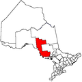
Towns Townships Dubreuilville • Hilton • Hornepayne • Huron Shores • Jocelyn • Johnson • Laird • Macdonald, Meredith and Aberdeen Additional • North Shore • Plummer Additional • Prince • St. Joseph • Tarbutt and Tarbutt Additional • Wawa • White RiverVillages Hilton BeachFirst Nations Batchewana • Garden River • Hornepayne • Michipicoten • Missanabie • Mississauga • Sagamok • Serpent River • ThessalonIndian reserves Chapleau 61 • Garden River • Goulais Bay • Gros Cap • Gros Cap Village • Missanabie • Mississagi River • Obadjiwan • Rankin Location • Sagamok • Serpent River • Thessalon • Whitefish IslandLocal services boards Aweres • Batchawana Bay • Goulais and District • Hawk Junction • Missanabie • Peace Tree • Searchmont • Wharncliffe and KynochUnorganized areas North • South EastSee also: Communities in Algoma District • Census divisions of Ontario Categories:- Municipalities in Algoma District, Ontario
- Township municipalities in Ontario
- Company towns in Canada
- Ontario communities with large francophone populations
- Northern Ontario geography stubs


Wikimedia Foundation. 2010.