- Stoke Park, Bristol
-
Coordinates: 51°29′28″N 2°33′17″W / 51.491096°N 2.554622°W
Stoke Park 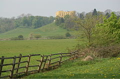
Stoke Park and The Dower House, viewed from the M32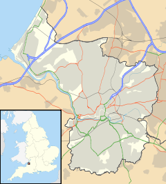
 Stoke Park
 Stoke Park shown within Bristol
OS grid reference ST 61590 77051 List of places: UK • England • Bristol Stoke Park is a public open space of 108 hectares (270 acres) in Bristol, England. It occupies a prominent position alongside the M32 motorway, together with the landmark Dower House and Purdown transmitter.[1]
Stoke Park is expected to be formally acquired by Bristol City Council in spring 2011. A celebration day to mark the acquisition of the park was scheduled for 19 March 2011.[2]
Bristol City Council plan to keep a herd of organic Dexter cattle in the park, both as a supply of beef and as an educational resource.[3]
Contents
The Dower House
The Dower House is one Bristol's more prominent landmarks, set on a hill above the M32 motorway on the main approach into the city, and painted bright yellow. The house was built in 1553 by Sir Richard Berkeley. It has also been used as Pur Down Hospital and the Burden Neurological Institute. The house closed as a hospital in 1985, and has since been converted into flats.
Duchess Pond
Within Stoke Park are two small lakes, the largest of which is Duchess Pond. It is used for angling and also supports several species of breeding bird which are scarce elsewhere in Bristol, for example, Reed Warbler and Reed Bunting; in addition, an Egyptian Goose was seen here in 2006.[4]
Other facilities
- Hermitage Tunnel
- Purdown transmitter
- Woodland areas and trees.
- World War II gun emplacements on Purdown
References
- ^ "Stoke Park". Bristol City Council. http://www.bristol.gov.uk/ccm/content/Environment-Planning/Parks-and-open-spaces/parks/stoke-park.en. Retrieved 2011-03-17.
- ^ "Stoke Park celebration day". Bristol City Council. http://www.bristol.gov.uk/ccm/content/Environment-Planning/Parks-and-open-spaces/parks/stoke-park.en?page=3#internalSection3. Retrieved 2011-03-18.
- ^ "Bristol City Council one step closer to setting up its own beef farm at Stoke Park". Bristol Evening Post. http://www.thisisbristol.co.uk/news/Oo-ar-join-council-s-farm/article-3323809-detail/article.html. Retrieved 2011-03-17.
- ^ Bland, R. L. and J. Tully (2011) The Breeding Season Atlas of the Birds of Bristol 2000-2008 Bristol Ornithology 30:3-59
Categories:- Parks and open spaces in Bristol


Wikimedia Foundation. 2010.