- Magnet Mill, Chadderton
-
Coordinates: 53°32′16″N 2°08′46″W / 53.5378°N -2.1461°E
Magnet 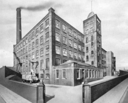
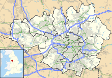
 Shown within Greater Manchester
Cotton Spinning (ring mill) Location Denton Lane, Chadderton Serving canal Rochdale Canal Magnet Mill Ltd. Further ownership Lancashire Cotton Corporation (1930s) Courtaulds (1964) Coordinates 53°32′16″N 2°08′46″W / 53.5378°N -2.1461°E Construction Built 1902 Demolished 1966c c. 1966 Power Date 1902 Construction Firm George Saxon Engine Type twin tandem compound engine Valve Gear Corliss valves rpm 64½ Diameter of Flywheel 27ft Type of transmission rope No, of Ropes. 35 Boiler configuration Pressure 160psi Equipment Manufacturer Howard & Bullough Mule Frames 60,156 spindles (1915) References [1] [2] Magnet Mill, Chadderton is a cotton spinning mill in Chadderton, Oldham, Greater Manchester. It was built by the Magnet Mill Ltd. in 1902, but purchased by the Lancashire Cotton Corporation in the 1930s. It was later taken over by the Courtaulds Group. Ceasing textile production in December 1966, it was demolished soon after. A suburban residential estate now occupies this site. It was driven by a 2200 hp twin tandem compound engine by George Saxon, Openshaw, 1903. It had a 27–foot flywheel with 35 ropes, operating at 64½ rpm.
Contents
Location
Oldham is a large town in Greater Manchester, England.[3] It lies amongst the Pennines on elevated ground between the rivers Irk and Medlock, 5.3 miles (8.5 km) south-southeast of Rochdale, and 6.9 miles (11.1 km) northeast of the city of Manchester. Oldham is surrounded by several smaller settlements which together form the Metropolitan Borough of Oldham; Chadderton and Hollinwood are such settlements. Chadderton and Hollinwood are served by the Rochdale Canal and the Hollinwood Branch Canal. A rail service was provided by the Oldham Loop Line that was built by the Lancashire and Yorkshire Railway.
History
Oldham rose to prominence during the 19th century as an international centre of textile manufacture. It was a boomtown of the Industrial Revolution, and amongst the first ever industrialised towns, rapidly becoming "one of the most important centres of cotton and textile industries in England",[4] spinning Oldham counts, the coarser counts of cotton. Oldham's soils were too thin and poor to sustain crop growing, and so for decades prior to industrialisation the area was used for grazing sheep, which provided the raw material for a local woollen weaving trade.[5] It was not until the last quarter of the 18th century that Oldham changed from being a cottage industry township producing woollen garments via domestic manual labour, to a sprawling industrial metropolis of textile factories.[5] The first mill, Lees Hall, was built by William Clegg in about 1778. Within a year, 11 other mills had been constructed,[6] but by 1818 there were only 19 of these privately owned mills.[7]
It was in the second half of the 19th century, that Oldham became the world centre for spinning cotton yarn.[7] This was due in a large part to the formation of limited liability companies known as Oldham Limiteds. In 1851, over 30% of Oldham's population was employed within the textile sector, compared to 5% across Great Britain.[8] At its zenith, it was the most productive cotton spinning mill town in the world,.[9][10] By 1871 Oldham had more spindles than any country in the world except the United States, and in 1909, was spinning more cotton than France and Germany combined.[11] By 1911 there were 16.4 million spindles in Oldham, compared with a total of 58 million in the United Kingdom and 143.5 million in the world; in 1928, with the construction of the UK's largest textile factory Oldham reached its manufacturing zenith.[7] At its peak, there were over 360 mills, operating night and day;[12][13]
The industry peaked in 1912 when it produced 8 billion yards of cloth. The Great War of 1914–18 halted the supply of raw cotton, and the British government encouraged its coloniess to build mills to spin and weave cotton. The war over, Lancashire never regained its markets. The independent mills were struggling. The Bank of England set up the Lancashire Cotton Corporation in 1929 to attempt to rationalise and save the industry.[14] Magnet Mill, Chadderton was one of 104 mills bought by the LCC, and one of the 53 mills that survived through to 1950.
Architecture
This was a F. W. Dixon Mill, built in 1902. Gurr & Hunt 1985, p. 40
Power
It was driven by a 2200 hp twin tandem compound engine by George Saxon, Openshaw, 1903. It had a 27–foot flywheel with 35 ropes, operating at 64½ rpm The-two 20"HP and two 44"LP cylinders had a 5 ft stroke. All had Corliss valves. There were no tail rods but semi-circular supports to piston rods between each pair of cylinders. The air pumps were driven from each crosshead. The boiler produced steam at 160psi. [15]
Equipment
In 1915 there were 60,156 mule spindles, and 44,680 ring spindles supplied by Howard & Bullough. Gurr & Hunt 1985, p. 40
Later extensions
Usage
Owners
- Magnet Mill Ltd (1902–1930s)
- Lancashire Cotton Corporation (1930s–1964)
- Courtaulds (1964–
Tenants
Notable events/media
See also
Lancashire cotton Architects 
Engine makers Daniel Adamson · Ashton Frost · Ashworth & Parker · Bateman & Sherratt · Boulton & Watt · Browett & Lindley · Buckley & Taylor · Carel · Earnshaw & Holt · Goodfellow · Fairbairn · W & J Galloway & Sons · B Goodfellow · Hick, Hargreaves & Co · Benjamin Hick and Sons · John Musgrave & Sons · J & W McNaught · Petrie of Rochdale · George Saxon · Scott & Hodgson · Urmson & Thompson · Yates of Blackburn · Yates & Thom · Whilans · J & E Wood · Woolstenhulmes & RyeMachinery makers Brooks & Doxey · Butterworth & Dickinson · Curtis, Parr & Walton · Dobson & Barlow · John Hetherington & Sons · Joseph Hibbert · Howard & Bullough · Geo. Hattersley · Asa Lees · Mather & Platt · Parr, Curtis & Madely · Platt Brothers · Taylor, Lang & Co · Textile Machinery Makers Ltd · Tweedales & Smalley- Oldham Limiteds · Fine Spinners and Doublers · Lancashire Cotton Corporation · Courtaulds · Bagley & WrightIndustrial processes Textile manufacturing · Cotton-spinning machinery · Friction Spinning · Magnetic ring spinning · Open end spinning · Ring spinning · Spinning frame · Spinning jenny · Spinning mule · Water frame · Roberts Loom · Lancashire LoomLists of mills LCC mills · Bolton · Bury · Cheshire · Derbyshire · Lancashire · Manchester · Oldham · Rochdale · Salford · Stockport · Tameside · WiganMuseums Bury Pilot Mill, Bury · Wilton Mill, Radcliffe
Bolton Lancashire Manchester and Salford Oldham Ace Mill, Hollinwood · Blackridings Mill, Oldham · Dawn Mill, Shaw · Fox Mill, Hollinwood · Hawk Mill, Shaw · Heron Mill, Hollinwood · Junction Mill, Middleton Junction · Kent Mill, Chadderton · Laurel Mill, Middleton Junction · Magnet Mill, Chadderton · Majestic Mill, Waterhead · Manor Mill, Chadderton · Newby Mill, Shaw · Orme Mill, Waterhead · Regent Mill, Failsworth · Royd Mill, Oldham · Royton Ring Mill, Royton · Rutland Mill, Shaw · Textile Mill, Chadderton · Trent Mill, ShawRochdale Stockport Elder Mill, Romiley · Kingston Mill, Stockport · Palmer Mills, Stockport · Vernon Mill, Stockport · Welkin Mill, Lower BredburyTameside Atlas Mill, Ashton-under-Lyne · Cedar Mill, Ashton-under-Lyne · Rock Mill, Ashton-under-Lyne · Saxon Mill, Droylsden · Stalybridge Mill, Stalybridge · Texas Mill, Ashton-under-Lyne · Tudor Mill, Ashton-under-Lyne · Waterside Mill, Ashton-under-LyneWigan West Yorkshire Foxsons Mill, Staincliffe · Mons Mill, TodmordenReferences
- ^ LCC 1951
- ^ Gurr & Hunt 1985, p. 77.
- ^ Greater Manchester Gazetteer, Greater Manchester County Record Office, Places names - O to R, http://www.gmcro.co.uk/Guides/Gazeteer/gazzo2r.htm, retrieved 9 July 2007
- ^ Oldham County Borough Council (1973), Official Handbook of Oldham
- ^ a b Butterworth, Edwin (1981), Historical Sketches of Oldham, E.J. Morten, ISBN 978-0-85972-048-9
- ^ Bateson, Hartley (1949), A Centenary History of Oldham, Oldham County Borough Council, ISBN 5-00-095162-X
- ^ a b c . McNeil, R.; Nevell, M. (2000), A Guide to the Industrial Archaeology of Greater Manchester, Association for Industrial Archaeology, ISBN 0-9528930-3-7
- ^ Foster, John (1974), Class Struggle and the Industrial Revolution - Early industrial capitalism in three English towns, Weidenfield & Nicolson, ISBN 978-0-297-76681-0
- ^ Gurr & Hunt 1998, pp. 1–5.
- ^ NW Cotton Towns Learning Journey, spinningtheweb.org.uk, http://www.spinningtheweb.org.uk/journey.php?Title=NW+Cotton+towns+learning+journey&step=2&theme=places, retrieved 2007-09-14
- ^ Oldham Metropolitan Borough Council (2001) (PDF), Contaminated Land Strategy 2001, oldham.gov.uk, p. 16, http://www.oldham.gov.uk/contaminatedlandstrategy.pdf, retrieved 2008-03-11
- ^ Visit Oldham – The History of Oldham, visitoldham.co.uk, archived from the original on 2007-08-06, http://web.archive.org/web/20070806150248/http://www.visitoldham.co.uk/heritage/history.htm, retrieved 2007-09-16
- ^ Spinning The Web - Oldham, spinningtheweb.org.uk, http://www.spinningtheweb.org.uk/m_display.php?irn=52&sub=nwcotton&theme=places&crumb=Oldham, retrieved 2006-06-28
- ^ Dunkerley
- ^ Roberts 1921
Notes
Bibliography
- Dunkerley, Philip (2009). "Dunkerley-Tuson Family Website, The Regent Cotton Mill, Failsworth". http://dunkerley-tuson.co.uk/regentmill.aspx. Retrieved 2009-01-09.
- Gurr, Duncan; Hunt, Julian (1985). The Cotton Mills of Oldham. Oldham Education & Leisure. ISBN 0-902809-46-6. http://www.spinningtheweb.org.uk/a_results.php?x=5&y=7&QueryName=KeyWord&KeyWords=The+Cotton+Mills+of+Oldham%2C+brief+history+and+gazetteer.
- LCC (1951). The mills and organisation of the Lancashire Cotton Corporation Limited. Blackfriars House, Manchester: Lancashire Cotton Corporation Limited.
- Roberts, A S (1921), "Arthur Robert's Engine List", Arthur Roberts Black Book. (One guy from Barlick-Book Transcription), http://oneguyfrombarlick.co.uk/forum_topic.asp?TOPIC_ID=7926&FORUM_ID=99&CAT_ID=3&Forum_Title=Rare+Text+(Book+Transcriptions)&Topic_Title=ARTHUR+ROBERTS+ENGINE+LIST&whichpage=1&tmp=1#pid81483, retrieved 2009-01-11
External links
Categories:- Textile mills owned by the Lancashire Cotton Corporation
- Textile mills in Oldham
- Chadderton


Wikimedia Foundation. 2010.