- Magyar Autonomous Region
-
Magyar Autonomous Region
Regiunea Autonomă Maghiară
Magyar Autonóm Tartományautonomous region of the People's Republic of Romania 1952–1968 Magyar Autonomous Region (1952-1960) and Mureş-Magyar Autonomous Region (1960-1968)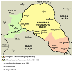
Capital Târgu-Mureş History - Established 1952 - Disestablished 1968 Today part of Romania  Magyar Autonomous Region in Romania, 1953
The Magyar Autonomous Region (1952-1960) (Romanian: Regiunea Autonomă Maghiară, Hungarian: Magyar Autonóm Tartomány) and Mureş-Magyar Autonomous Region (1960-1968) were autonomous regions in the People's Republic of Romania (later Socialist Republic of Romania).
Contents
History
In 1950, Romania adopted a Soviet-style administrative and territorial division of the country into regions and raions (until then, Romania had been divided into judeţe or counties).
Two years later, in 1952, the number of regions was reduced and by comprising ten raions from the former Mureş Region and from the Stalin Region (both of them created in 1950), of the territory inhabited by a compact population of Székely Hungarians, a new region called the Magyar Autonomous Region was created.[1] According to the 1956 census, the total population of the region was 731,361, distributed among the ethnic groups as follows: Hungarians (77.3%), Romanians (20.1%), Gypsies (1.5%), Germans (0.4%) and Jews (0.4%). The official languages of the province were Hungarian and Romanian and the provincial administrative centre was Târgu-Mureş (Marosvásárhely).
Its status laid out in the 1952 Constitution, the region encompassed about a third of Romania's Hungarians, the rest living either in more Romanian areas or along the border with Hungary, where an ethnic-based region might have stoked fears[citation needed] of irredentism and security concerns. In practice, the region's status differed in no way from that of the other seventeen regions and it did not enjoy autonomy[citation needed] of any kind–laws, decisions and directives from the centre were rendered compulsory by the very constitution that created it, and the State Council of the Autonomous Region was merely a façade.[citation needed] The Region's only distinguishing features were that most of its officials were Hungarian, the Hungarian language could be used in administration and the courts, and bilingual signs were put up on public buildings. Moreover, the specifically Hungarian wing of the Romanian Communist Party was abolished in 1953, ending any mechanism for defending of the Hungarian minority's collective rights.[2]
 Nicolae Ceauşescu and Mureş-Magyar Autonomous Region delegation at the IXth Congress of the Romanian Communist Party in July 1965
In December 1960 a governmental decree modified the boundaries of the Magyar Autonomous Region. Its southern raions were reattached to Braşov Region (former Stalin Region) and in place of this, several raions were joined to it from the Cluj Region. The region was called the Mureş Region-Magyar Autonomous, after the Mureş River. The ratio of Hungarians was thus reduced from 77.3 percent to 62 percent.
In 1968, the Great National Assembly put an end to the soviet style administrative division of the country into regions and re-introduced the historical judeţ (county) system, still used today. This also automatically eliminated the Mureş-Magyar Autonomous Region and replaced it with counties that are not identified with any nationality. The two new counties formed on the majority of the territory of former Mureş-Magyar Autonomous Region are Mureş and Harghita plus one from the former Magyar Autonomous Region until 1960 and part of the Braşov Region in 1968, Covasna.
In two of these counties, Harghita and Covasna, Hungarians form the majority of inhabitants. The Romanian law enables the usage of the language of an ethnic minority which forms at least 20% of the population of a municipality in relation with the administration, and the state provides education and public signage in the language of the respective ethnic minority.
Neighbors
 The regions of Peoples' Republic of Romania between 1960-1968
- Magyar Autonomous Region had as neighbors (1952-1960):
East: Bacău and Bârlad Regions;
South: Stalin and Ploieşti Regions;
West: Cluj Region;
North: Suceava Region- Mureş Region-Magyar Autonomous had as neighbors (1960-1968):
East: Bacău Region;
South: Braşov Region;
West: Cluj Region;
North: Suceava regionSee also
- Regions of the Peoples' Republic of Romania
- Hungarian minority in Romania
- Székely
- Székely Land
- Ethnic clashes of Târgu Mureş
- Northern Transylvania
- Transylvania
References
- ^ The Constitution of the Peoples' Republic of Romania, 1952 (Romanian)
- ^ Deletant, Dennis, Ceauşescu and the Securitate: Coercion and Dissent in Romania, 1965-1989, pp. 109-110. M.E. Sharpe, London, 1995, ISBN 1563246333
External links
- Map: Közigazgatási Beosztás 1956 Map of the administrative divisions in Transylvania in 1956, including the Hungarian Autonomous Province
- Map: Közigazgatási Beosztás 1966 Map of the administrative divisions in Transylvania in 1966, including the Mureş-Hungarian Autonomous Province
- Map: A Székelyföld autonómiája, 1952-1968 ("Autonomous Székelyföld, 1952-1968"): Map of the Hungarian Autonomous Province (1952-1960) and Mureş-Hungarian Autonomous Province (1960-1968)
- Map: Republica Populară Română, Structura Administrativ-Teritorală (1952) ("Romanian People's Republic, Administrative-Territorial Structure (1952)"), showing the Hungarian Autonomous Province ("Reg. Autonomă Maghiara").
Categories:- Communist Romanian regions
- Székely
- History of Transylvania
- 1968 disestablishments
- States and territories established in 1952


Wikimedia Foundation. 2010.