- Mountain peaks of Mexico
-
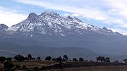
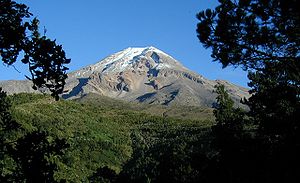 Volcán Citlaltépetl (Pico de Orizaba), a stratovolcano on the boundary between the states of Puebla and Veracruz, is the highest mountain peak of Mexico.
Contents
Main article: Geography of MexicoSee also: Mountain peaks of North AmericaThis article comprises three sortable tables of the major mountain peaks of Mexico.
Topographic elevation is the vertical distance above the reference geoid, a precise mathematical model of the Earth's sea level as an equipotential gravitational surface. Topographic prominence is the elevation difference between the summit and the highest or key col to a higher summit. Topographic isolation is the minimum great circle distance to a point of higher elevation.
This article defines a significant summit as a summit with at least 100 meters (328.1 feet) of topographic prominence, and a major summit as a summit with at least 500 meters (1640.4 feet) of topographic prominence. An ultra-prominent summit is a summit with at least 1500 meters (4921.3 feet) of topographic prominence. There are 28 ultra-prominent summits in Mexico.
The following tables are under active development. Please suggest changes and additions on the discussion page.
Highest major summits
The following sortable table lists the 30 highest mountain peaks of Mexico with at least 500 meters (1640.4 feet) of topographic prominence. Three major summits exceed 5000 meters (16,404.2 feet) of elevation, 8 exceed 4000 meters (13,123.4 feet), and 25 exceed 3000 meters (9842.5 feet).
Of these 30 highest major summits, 4 are located in Puebla, 4 in Oaxaca, 4 in Coahuila, 3 in México, 3 in Jalisco, 3 in Nuevo León, 2 in Chiapas, 2 in Michoacán, 2 in Querétaro, and one each in Distrito Federal, Morelos, Tlaxcala, Veracruz, Guerrero, Guanajuato, Durango, Baja California, and Aguascalientes.
Most prominent summits
See also: Table of the ultra-prominent summits of MexicoThe following sortable table lists the 30 most topographically prominent mountain peaks of Mexico. Volcán Citlaltépetl (Pico de Orizaba) exceeds 4000 meters (13,123.4 feet) of topographic prominence, Volcán Popocatépetl exceeds 3000 meters (9842.5 feet), 9 major summits exceed 2000 meters (6561.7 feet), and 28 major peaks qualify as ultra-prominent summits with at least 1500 meters (4921.3 feet).
Of these 30 most prominent summits, 6 are located in Oaxaca, 4 in Puebla, 4 in Nuevo León, 3 in México, 3 in Jalisco, 2 in Michoacán, 2 in Baja California Sur, 2 in Coahuila, 2 in Querétaro, and one each in Morelos, Chiapas, Guerrero, Baja California, Tlaxcala, Veracruz, and Guanajuato.
Most isolated major summits
The following sortable table lists the 30 most topographically isolated mountain peaks of Mexico with at least 500 meters (1640.4 feet) of topographic prominence. All 30 of these peaks exceed 100 kilometers (62.14 miles) of topographic isolation.
Of these 30 most isolated major summits, 4 are located in Baja California, 4 in Oaxaca, 3 in Baja California Sur, 2 in Puebla, 2 in Nuevo León, 2 in Coahuila, 2 in Chiapas, 2 in México, 2 in Michoacán, and one each in Colima, Durango, Jalisco, Aguascalientes, Guerrero, Veracruz, Chihuahua, Sonora, Morelos, Guanajuato, and Querétaro.
Gallery
-
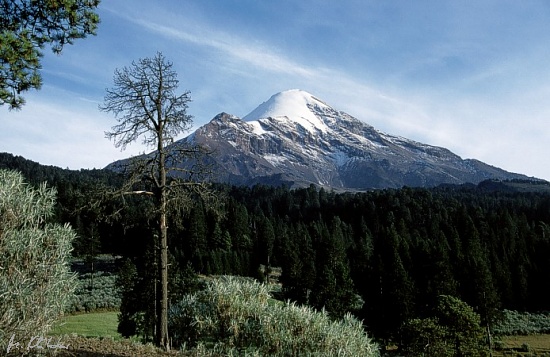
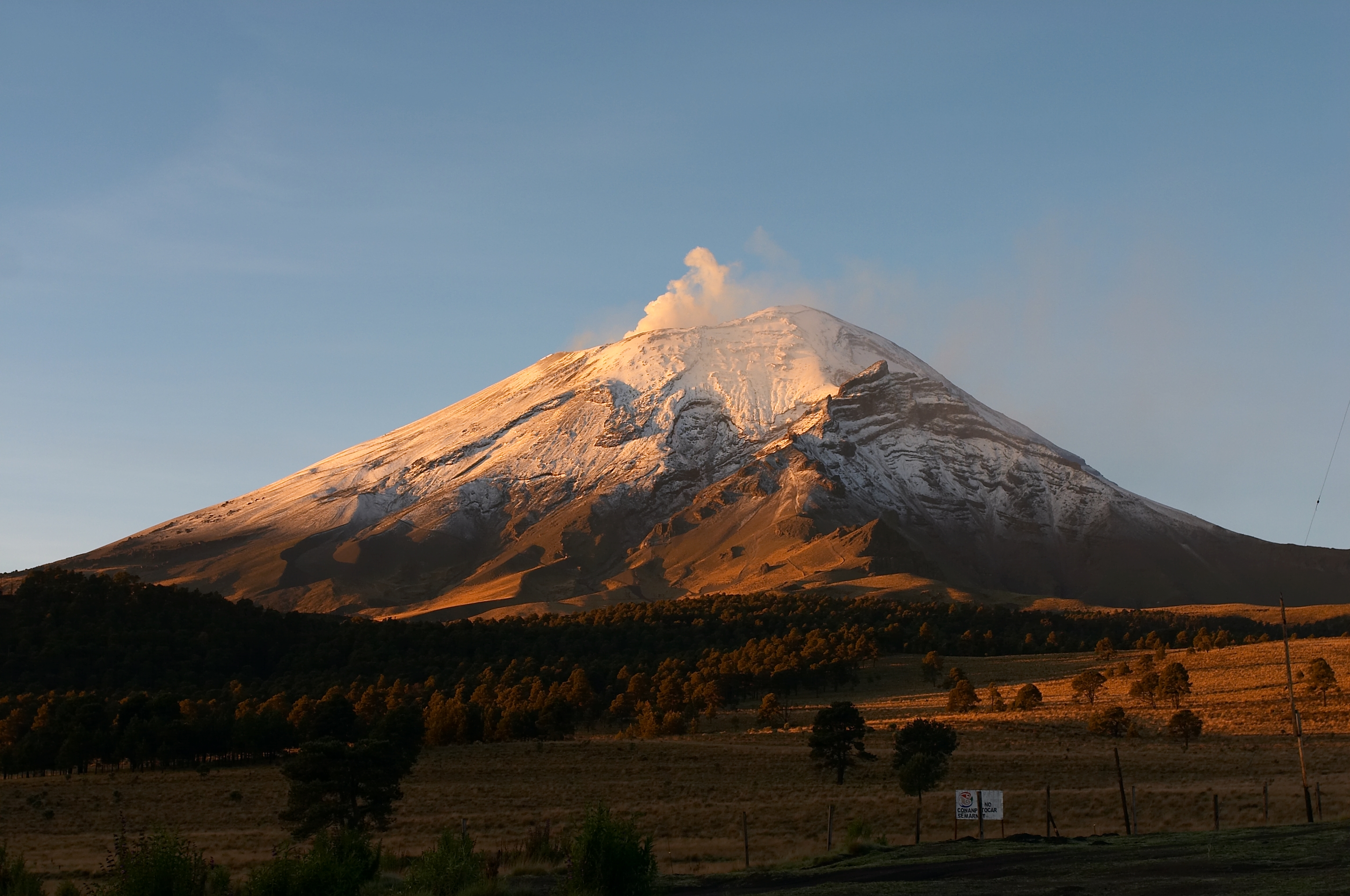
The summit of Pico de Orizaba, a stratovolcano on the border between Puebla and Veracruz, is the highest peak of Mexico.
-
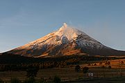
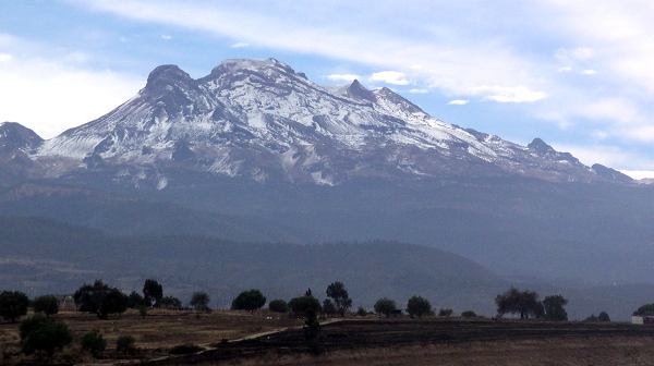
The summit of Volcán Popocatépetl, a stratovolcano at the junction of Puebla, Mexico State, and Morelos, is the second highest peak of Mexico.
-
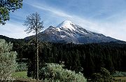
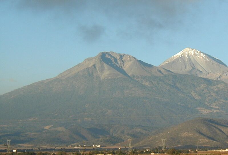
The summit of Volcán Iztaccíhuatl, a stratovolcano on the border between Puebla and Mexico State, is the third highest peak of Mexico.
-

Nevado de Toluca is a stratovolcano in Mexico State.
-

The stratovolcano Sierra Negra in Puebla with Pico de Orizaba in the background.
-

The stratovolcano Matlalcueitl straddles the border between Tlaxcala and Puebla.
-

Nevado de Colima is a stratovolcano in Colima.
-

Cofre de Perote is a shield volcano in Veracruz.
See also
- Outline of Mexico
- Index of Mexico-related articles
- Lists of mountains
- Mexico
- Geography of Mexico
- Category:Mountains of Mexico
- Geography of Mexico
- Mountain peaks of North America
- Mountain peaks of Greenland
- Mountain peaks of Canada
- Mountain peaks of the Rocky Mountains
- Mountain peaks of the United States
- Mountain peaks of Mexico
- The 28 ultra-prominent peaks of Mexico
- Mountain peaks of Central America
- Mountain peaks of the Caribbean
- Physical geography
- Topography
- Topographic elevation
- Topographic isolation
- Topographic prominence
- Topographic summit
- Topography
References
- ^ a b c The summit of Volcán Citlaltépetl (Pico de Orizaba) is the highest point of Estado Libre y Soberano de Puebla, Estado Libre y Soberano de Veracruz de Ignacio de la Llave, and all of México.
- ^ a b c "Volcán Citlaltépetl". Summits of the World. peakbagger.com. http://www.peakbagger.com/peak.aspx?pid=8049. Retrieved January 2, 2010.
- ^ a b c The summit of Volcán Popocatépetl on the border of Estado Libre y Soberano de Puebla is the highest point of both Estado Libre y Soberano de México and Estado Libre y Soberano de Morelos..
- ^ a b c "Volcán Popocatépetl". Summits of the World. peakbagger.com. http://www.peakbagger.com/peak.aspx?pid=8034. Retrieved January 2, 2010.
- ^ a b "Volcán Iztaccíhuatl". Summits of the World. peakbagger.com. http://www.peakbagger.com/peak.aspx?pid=8033. Retrieved January 2, 2010.
- ^ a b c "Nevado de Toluca". Summits of the World. peakbagger.com. http://www.peakbagger.com/peak.aspx?pid=8028. Retrieved January 2, 2010.
- ^ a b The summit of Volcán Matlalcuéyetl (La Malinche) on the border of Estado Libre y Soberano de Puebla is the highest point of Estado Libre y Soberano de Tlaxcala.
- ^ a b "Volcán Matlalcuéyetl". Summits of the World. peakbagger.com. http://www.peakbagger.com/peak.aspx?pid=8037. Retrieved January 2, 2010.
- ^ a b c The summit of Nevado de Colima is the highest point of Estado Libre y Soberano de Jalisco.
- ^ a b c "Nevado de Colima". Summits of the World. peakbagger.com. http://www.peakbagger.com/peak.aspx?pid=8009. Retrieved January 2, 2010.
- ^ "Volcán Cofre de Perote". Summits of the World. peakbagger.com. http://www.peakbagger.com/peak.aspx?pid=8036. Retrieved January 2, 2010.
- ^ a b The summit of Volcán Tacaná on the international border with Guatemala is the highest point of Estado Libre y Soberano de Chiapas.
- ^ a b "Volcán Tacaná". Summits of the World. peakbagger.com. http://www.peakbagger.com/peak.aspx?pid=8075. Retrieved January 2, 2010.
- ^ The summit of Cerro Ajusco is the highest point of the Distrito Federal.
- ^ "Cerro Ajusco". Summits of the World. peakbagger.com. http://www.peakbagger.com/peak.aspx?pid=8027. Retrieved September 16, 2010.
- ^ a b c The summit of Volcán Tancítaro is the highest point of Michoacán.
- ^ a b c "Volcán Tancítaro". Summits of the World. peakbagger.com. http://www.peakbagger.com/peak.aspx?pid=8013. Retrieved January 2, 2010.
- ^ a b c The summit of Cerro Nube (Quie Yelaag) is the highest point of the Sierra Madre del Sur and Estado Libre y Soberano de Oaxaca.
- ^ a b c "Cerro Nube". Summits of the World. peakbagger.com. http://www.peakbagger.com/peak.aspx?pid=8058. Retrieved January 10, 2010.
- ^ a b c "Cerro El Potosí". Summits of the World. peakbagger.com. http://www.peakbagger.com/peak.aspx?pid=7984. Retrieved January 10, 2010.
- ^ a b "Cerro El Nacimiento". Summits of the World. peakbagger.com. http://www.peakbagger.com/peak.aspx?pid=8059. Retrieved January 10, 2010.
- ^ The summit of Cerro San Rafael is the highest point of the Sierra Madre Oriental and Estado Libre y Soberano de Coahuila.
- ^ "Cerro San Rafael". Summits of the World. peakbagger.com. http://www.peakbagger.com/peak.aspx?pid=7981. Retrieved January 10, 2010.
- ^ The summit of Cerro El Morro on the border with Coahuila is the highest point of Estado Libre y Soberano de Nuevo León.
- ^ "Cerro El Morro". Summits of the World. peakbagger.com. http://www.peakbagger.com/peak.aspx?pid=7983. Retrieved January 10, 2010.
- ^ a b c The summit of Cerro Tiotepec is the highest point of Estado Libre y Soberano de Guerrero.
- ^ a b c "Cerro Tiotepec". Summits of the World. peakbagger.com. http://www.peakbagger.com/peak.aspx?pid=8054. Retrieved January 10, 2010.
- ^ a b c "Picacho San Onofre". Summits of the World. peakbagger.com. http://www.peakbagger.com/peak.aspx?pid=7987. Retrieved January 3, 2010.
- ^ a b c "Cerro Zempoaltepetl". Summits of the World. peakbagger.com. http://www.peakbagger.com/peak.aspx?pid=8056. Retrieved January 10, 2010.
- ^ a b c The summit of Cerro El Zamorano is the highest point of both Estado Libre y Soberano de Guanajuato and Estado Libre y Soberano de Querétaro Arteaga.
- ^ a b c "Cerro El Zamorano". Summits of the World. peakbagger.com. http://www.peakbagger.com/peak.aspx?pid=7976. Retrieved January 10, 2010.
- ^ a b c "Cerro del Águila". Summits of the World. peakbagger.com. http://www.peakbagger.com/peak.aspx?pid=13297. Retrieved January 3, 2010.
- ^ a b The summit of Cerro Gordo is the highest point of the Sierra Madre Occidental and Estado Libre y Soberano de Durango.
- ^ a b "Cerro Gordo". Summits of the World. peakbagger.com. http://www.peakbagger.com/peak.aspx?pid=7953. Retrieved January 27, 2010.
- ^ a b c "Cerro El Centinela". Summits of the World. peakbagger.com. http://www.peakbagger.com/peak.aspx?pid=7966. Retrieved January 10, 2010.
- ^ a b c The summit of Picacho del Diablo is the highest point of Estado Libre y Soberano de Baja California.
- ^ a b c "Picacho del Diablo". Summits of the World. peakbagger.com. http://www.peakbagger.com/peak.aspx?pid=1537. Retrieved January 10, 2010.
- ^ a b The summit of Sierra Fría is the highest point of Estado Libre y Soberano de Aguascalientes.
- ^ a b "Sierra Fría". Summits of the World. peakbagger.com. http://www.peakbagger.com/peak.aspx?pid=7957. Retrieved January 10, 2010.
- ^ a b c "Sierra La Madera". Summits of the World. peakbagger.com. http://www.peakbagger.com/peak.aspx?pid=13307. Retrieved January 10, 2010.
- ^ a b "Volcán de Tequila". Summits of the World. peakbagger.com. http://www.peakbagger.com/peak.aspx?pid=7999. Retrieved January 11, 2010.
- ^ a b "Cerro La Joya". Summits of the World. peakbagger.com. http://www.peakbagger.com/peak.aspx?pid=13305. Retrieved January 10, 2010.
- ^ a b "Cerro Tzontehuitz". Summits of the World. peakbagger.com. http://www.peakbagger.com/peak.aspx?pid=8071. Retrieved January 2, 2010.
- ^ a b c "Cerro Las Conchas". Summits of the World. peakbagger.com. http://www.peakbagger.com/peak.aspx?pid=13308. Retrieved January 10, 2010.
- ^ a b "Cerro Las Capillas". Summits of the World. peakbagger.com. http://www.peakbagger.com/peak.aspx?pid=13303. Retrieved January 11, 2010.
- ^ a b The summit of Sierra La Laguna High Point is the highest point in Estado Libre y Soberano de Baja California Sur.
- ^ a b "Sierra La Laguna High Point". Summits of the World. peakbagger.com. http://www.peakbagger.com/peak.aspx?pid=21386. Retrieved January 2, 2010.
- ^ "Cerro Tia Chena". Summits of the World. peakbagger.com. http://www.peakbagger.com/peak.aspx?pid=13306. Retrieved January 3, 2010.
- ^ "El Aguacate Oeste". Summits of the World. peakbagger.com. http://www.peakbagger.com/peak.aspx?pid=13304. Retrieved January 3, 2010.
- ^ a b "Volcán Las Tres Vírgenes". Summits of the World. peakbagger.com. http://www.peakbagger.com/peak.aspx?pid=1535. Retrieved January 2, 2010.
- ^ a b "Sierra de Santa Martha". Summits of the World. peakbagger.com. http://www.peakbagger.com/peak.aspx?pid=8041. Retrieved January 2, 2010.
- ^ "Picachos El Fraile". Summits of the World. peakbagger.com. http://www.peakbagger.com/peak.aspx?pid=13302. Retrieved January 11, 2010.
- ^ a b "Sierra El Cerro Azul". Summits of the World. peakbagger.com. http://www.peakbagger.com/peak.aspx?pid=8072. Retrieved January 10, 2010.
- ^ "Volcán Everman". Summits of the World. peakbagger.com. http://www.peakbagger.com/peak.aspx?pid=8004. Retrieved January 27, 2010.
- ^ "Isla Guadalupe High Point". Summits of the World. peakbagger.com. http://www.peakbagger.com/peak.aspx?pid=13288. Retrieved January 2, 2010.
- ^ "Isla Cedros High Point". Summits of the World. peakbagger.com. http://www.peakbagger.com/peak.aspx?pid=6182. Retrieved January 3, 2010.
- ^ The summit of Cerro San José on the border with Chihuahua is the highest point of Estado Libre y Soberano de Sonora.
- ^ "Cerro San José". Summits of the World. peakbagger.com. http://www.peakbagger.com/peak.aspx?pid=7962. Retrieved January 10, 2010.
- ^ "Cerro La Sandía". Summits of the World. peakbagger.com. http://www.peakbagger.com/peak.aspx?pid=1533. Retrieved January 2, 2010.
- ^ "Cerro Tres Picos". Summits of the World. peakbagger.com. http://www.peakbagger.com/peak.aspx?pid=8073. Retrieved January 2, 2010.
- ^ "Cerro La Giganta". Summits of the World. peakbagger.com. http://www.peakbagger.com/peak.aspx?pid=1540. Retrieved January 2, 2010.
External links
- Natural Resources Mexico (NRC)
- peakbagger.com
- peaklist.org
- summitpost.org
- World Mountain Encyclopedia @ peakware.com
States of Mexico States Aguascalientes · Baja California · Baja California Sur · Campeche · Chiapas · Chihuahua · Coahuila · Colima · Durango · Guanajuato · Guerrero · Hidalgo · Jalisco · México · Michoacán · Morelos · Nayarit · Nuevo León · Oaxaca · Puebla · Querétaro · Quintana Roo · San Luis Potosí · Sinaloa · Sonora · Tabasco · Tamaulipas · Tlaxcala · Veracruz · Yucatán · Zacatecas

Federal District Mountain peaks of North America Sovereign states - Antigua and Barbuda
- Bahamas
- Barbados
- Belize
- Canada
- Costa Rica
- Cuba
- Dominica
- Dominican Republic
- El Salvador
- Grenada
- Guatemala
- Haiti
- Honduras
- Jamaica
- Mexico
- Nicaragua
- Panama
- Saint Kitts and Nevis
- Saint Lucia
- Saint Vincent and the Grenadines
- Trinidad and Tobago
- United States
Dependencies and
other territories- Anguilla
- Aruba
- Bermuda
- Bonaire
- British Virgin Islands
- Cayman Islands
- Curaçao
- Greenland
- Guadeloupe
- Martinique
- Montserrat
- Puerto Rico
- Saint Barthélemy
- Saint Martin
- Saint Pierre and Miquelon
- Saba
- Sint Eustatius
- Sint Maarten
- Turks and Caicos Islands
- United States Virgin Islands
Categories:- Mountains of Mexico
- Lists of mountains by country
- Lists of mountains by elevation
- Lists of mountains by prominence
- Lists of mountains by isolation
- Lists of mountains of Mexico
- Mexico-related lists
-


Wikimedia Foundation. 2010.