- Control city
-
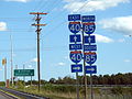
 This sign in Oklahoma City, Oklahoma lists control cities of Wichita, Kansas and Ft. Smith, Arkansas for Interstate 35 and Interstate 40 respectively.
A control city is a city or locality posted on a traffic sign indicating forward destinations on a certain route. These destinations aid motorists using the highway system to reach destinations along the various routes.[1] Such cities appear on signs at highway junctions to indicate where the intersecting road goes, or on mileage signs on longer routes.
Contents
United States
The determination of major destinations or control cities is important to the quality of service provided by the freeway. Control cities on freeway guide signs are selected by the States and are contained in the "List of Control Cities for Use in Guide Signs on Interstate Highways," published and available from American Association of State and Highway Transportation Officials.—Federal Highway Administration, Manual on Uniform Traffic Control Devices, 2003 Edition, Chapter 2E[2]The Manual on Uniform Traffic Control Devices (MUTCD) states that control cities should be used:
- At interchanges between freeways (example US-1 in gallery)
- At separation points of overlapping freeway routes (example US-2 in gallery)
- On directional signs on intersecting routes, to guide traffic entering the freeway (example US-3 in gallery)
- On pull-through signs (example US-4 in gallery)
- On the bottom line of post-interchange distance signs (example US-5 in gallery)
The individual states ultimately have the authority to decide which cities can be control cities,[3] but the American Association of State Highway and Transportation Officials retains the authority to approve the official list and standardizes all control cities used on the Interstate Highway system in the United States. The published standard is not always followed, for a few reasons – major destinations have since appeared that were not on the original list, new roads have been built that provide new routes, or because of state highway departments' hesitancy to sign destinations in other states. Some examples:
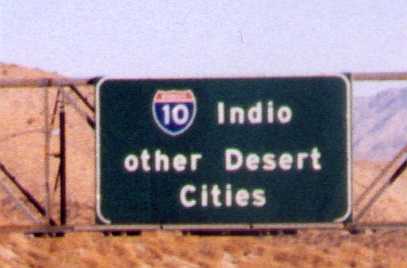
 I-10 in Southern California uses Indio and "other Desert Cities" to guide motorists east.
 I-76 (Pennsylvania Turnpike) uses "Ohio" to guide motorists west.
 North of Baltimore in Maryland, New York is used instead of closer Philadelphia or Wilmington.
 This sign in Petersburg, Virginia aids long-distance travelers, by listing the cities of Miami, Florida and Atlanta, Georgia.
- On eastbound Interstate 10 near Palm Springs, California, Caltrans uses the small city of Indio, California, and "other Desert Cities" [sic], though Phoenix, Arizona is the nearest major forward destination.[4] This inspired the title of a play by Jon Robin Baitz, Other Desert Cities.
- Sometimes, the opposite is true. In Washington state, Vancouver, British Columbia (signed "Vancouver B.C." to prevent confusion with Vancouver, Washington, which the same interstate goes through but in the opposite direction) is the control city for northbound Interstate 5 north of Seattle, which is reached via British Columbia Highway 99.[5] Similarly, Montreal is the control city for Interstate 87 north of Albany.
- Interstate 40 uses Los Angeles as a control city for motorists west of Flagstaff, even though I-40 does not reach Los Angeles, and neither does Interstate 15, which is at its western terminus.
- Interstate 57 uses Memphis as a control city for southbound motorists, even though the expressway does not reach Memphis or even enter the state of Tennessee; it ends near Sikeston, Missouri, 150 miles (240 km) to the north. The use of Memphis derives from Interstate 57 serving as an alternative to Interstate 55, which passes through the city.
- On Interstate 85 in North Carolina, NCDOT uses Richmond, Virginia as the control city even though it terminates at I-95 in Petersburg, Virginia, 20 miles (30 km) south of Richmond. VDOT uses Petersburg.[6]
- On Interstate 65, heading north out of Indianapolis, INDOT uses Chicago as the control city though I-65 terminates at Gary, Indiana, 17 miles (30 km) south of Chicago.
- On Interstate 515 in Las Vegas, the Nevada Department of Transportation (NDOT) uses Phoenix as the control city, though I-515 terminates in southeast suburban Henderson. I-515 runs concurrently with US 93 and US 95 along its entire length; traffic continues into the state of Arizona on non-Interstate-standard alignments of US 93 (with the US 93 portion crossing the Arizona state line over the Mike O'Callaghan – Pat Tillman Memorial Bridge, while the US 95 portion splits off just outside Henderson and Boulder City and heads south towards Searchlight and Cal-Nev-Ari, entering the state of California near Needles, where it merges with I-40). US 93 does not reach all the way to Phoenix, its southern terminus coming at a junction with US 60 in the town of Wickenburg, about 50 miles (80 km) northwest of Phoenix; southbound traffic into the Phoenix area continues on US 60 east.
A control city is not always a major city. For instance:
- Interstate 10 heading eastbound in El Paso uses Van Horn, Texas, a small city west of the western terminus of I-20.
- Interstate 10 heading eastbound out of New Orleans uses Slidell, a small city near I-12 and I-59's terminus.
- Interstate 10 heading eastbound out of Slidell uses Bay St. Louis, a small city west of Gulfport, Mississippi.
- Interstate 10 heading eastbound out of Tallahassee and westbound out of Jacksonville, as well as Interstate 75 heading northbound out of Ocala and southbound out of Valdosta, uses Lake City, a small city near where the two highways intersect.
- Interstate 12 uses Hammond where it crosses I-55 and Slidell a small city at the highway's terminus at I-10 and I-59's southern terminus.
- Interstate 35 heading south out of the Twin Cities uses Albert Lea, the last town before the Iowa border, and where I-35 intersects with I-90.
- Interstate 40 between Raleigh and Wilmington, North Carolina, uses Benson, the town near which it intersects I-95
- Interstate 55 heading northbound out of LaPlace uses Hammond, where it crosses I-12.
- Interstate 64 heading eastbound out of St. Louis uses Mount Vernon
- Interstate 66 heading westbound out of Washington, D.C. uses Front Royal, a small city near the highway's terminus of Strasburg, Virginia.
- Interstate 75 heading northbound out of Bay City, Michigan uses the Mackinac Bridge (nearly 200 miles (320 km) away) as a control city because there are no large cities north along the highway.
- Interstate 76 heading westbound out of Philadelphia, Pennsylvania, uses Valley Forge, a historic but minor locality where I-76 joins the Pennsylvania Turnpike.
- Interstate 76 westbound in the Pittsburgh area uses "Ohio and West" on overhead signs. I-76 (The Pennsylvania Turnpike) continues into Ohio as the Ohio Turnpike, where it meets I-80 and leaves the Turnpike while I-80 joins the Turnpike. This means that Youngstown, Ohio, Akron, Ohio, Cleveland, Ohio, and Toledo, Ohio (all control cities) are appropriate for I-76 westbound. Cleveland is used once in Pennsylvania as a control city for the Ohio Turnpike, as is Columbus, Ohio (for Interstate 70).[7]
- Interstate 77 in North Carolina uses Fort Chiswell, Virginia as a control city north of Statesville. Fort Chiswell is an unincorporated town that was chosen because it is the nearest community to I-77's junction with Interstate 81.
- Interstate 80 in Illinois uses Iowa as the westbound destination and Indiana as the eastbound destination, even though the Quad Cities could be used for westbound traffic and Gary, Indiana could be used for eastbound traffic.
- Interstate 81 heading north from Syracuse, New York uses Canada as its control city. Interstate 81 is connected directly to Highway 401 in Ontario, from which point both the major cities of Toronto and Montreal can be reached.
- Interstate 94 heading west out of the Twin Cities uses St. Cloud and then Moorhead, instead of the larger and more well-known neighbor, Fargo, North Dakota.
- Interstate H3 westbound in Hawaii uses Pearl Harbor, a physical feature and major naval base at its western terminus, instead of a city along Interstate H1. (example US-4 in gallery)
Occasionally, a closer large city is not a control city because a larger city is located farther along a highway. For example:
- Highway signs in Maryland on Interstate 95 northbound between the Interstate 395 junction in Baltimore and the Delaware border use New York City as their control city, even though I-95 directly passes through the closer Philadelphia, Pennsylvania and Wilmington, Delaware.
- At the interchange between Interstate 95 and Interstate 85 south of Richmond, the city of Miami, Florida (920 miles away) is indicated as a long-distance control city for I-95 south, and Atlanta, Georgia (500 miles away) is indicated as a long-distance control city for I-85 south, as well as including the next control cities of Rocky Mount, North Carolina and Durham, North Carolina, respectively.
- At the interchange of Interstate 70 and Interstate 81 in Hagerstown, Maryland, the control city for I-81 south is Roanoke, Virginia, over 200 miles (300 km) away, with the control cities of Martinsburg, West Virginia and Winchester, Virginia overlooked.[8]
- On westbound Interstate 94 within 15 miles of the Detroit Metro Airport, Chicago is listed as a control city, however other segments in between list Jackson, MI, Kalamazoo, MI and Benton Harbor, MI as they are closer together whereas Detroit and Chicago are larger cities with mutual guidance for long-distance motorists.
 On these signs in San Francisco, both the Golden Gate Bridge and the Bay Bridge are listed as control cities
Sometimes, a building or landmark may be posted as a control city instead of an actual settlement. On highway signs in San Francisco, for example, the "control city" for northbound U.S. Route 101 is the Golden Gate Bridge, while one for eastbound Interstate 80 is the San Francisco – Oakland Bay Bridge. In the Los Angeles metropolitan area, the "control city" for the westbound Glendale Freeway (SR 2) is the Echo Park neighborhood of the city of Los Angeles.
Canada
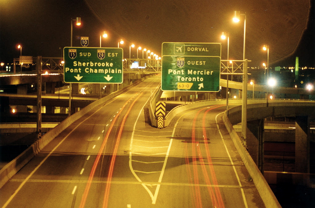
 The A20 can be used to reach the Mercier Bridge and Toronto from here in Montreal.
Control cities are particularly necessary for highways that do not follow strict linear directions. Ontario's Queen Elizabeth Way, for example, wraps around the western end of Lake Ontario, with segments proceeding both east and west at different points. Compass directions are not used at all in its central sections, and the control cities of Toronto and (for the opposite direction) Hamilton/Niagara Falls/Fort Erie are the only bearings provided.
Each of the 400-series highways uses control cities, but the common Ontario practice is to use smaller, and closer urban centres. For example, on Highway 401, Cornwall, rather than the much larger city of Montreal, is the eastbound control city east of Kingston.
The Ministère des Transports du Québec typically uses large urban centres as control cities, even if they are far away and even outside the province. For example, signs in Montreal, Quebec, indicate control cities as far as Toronto and Ottawa on major Autoroutes 20 and 40 respectively. New York and Vermont are used as control cities for Autoroutes 15 and 35 respectively.
Europe
Continental Europe
Unlike in the United States and Canada, roads in Continental Europe are not signed with directional banners (east, west, north, and south), so the direction of the route is indicated by a major city or destination (directly or indirectly) reached by the route (examples FR-1 and DK-1 below). While not called "control cities", the function is the same.
Britain and Ireland
On UK motorways, directional banners are often used, usually followed by the next largest city on the route. In the Republic of Ireland, directional banners are used on the M50.
Rest of World
Australia
Freeways, Motorways and Tollways in Australia, whilst not using the term 'Control City', operate on much the same system as in the United States and Europe. Directional markers are not used, instead the next large towns or cities which are likely to be the destination, or known waypoints for, motorists are used.
- Within cities major suburbs will usually be used - In the eastern suburbs of Melbourne Chadstone & Dandenong, which are connecting hubs with the national route 1, Princes Highway, are used as route markers. Traveling inbound, depending upon the drivers location in Melbourne's east one of these markers will generally be used along with a marker 'City' referring to the Central Business District. The marker 'city' is only used when within the metropolitan area of a city, outside of the metropolitan area routes traveling towards that city will use the city's full name.
- Outside of cities major regional centers or capital cities will generally be used as markers.
- The same principle applies to major and secondary surface roads in Australia, with the most major suburb or town, or the roads terminus in either directing being used as the 'control city'.
- In some circumstances a major infrastructure location, most often Airports, will be used as a 'Control' City. In the case of surface roads if they connect to a freeway, motorway or tollway sometimes this connection will be used as a signing point.
Gallery
-

US-1: I-95 and I-16 intersect.
-

US-2: I-40 and I-85 split. I-40 goes through Greensboro to Winston-Salem, while I-85 heads south to Charlotte.
-
US-3: Durham and Greensboro are used to aid motorists to decide which direction to go.
-

US-4: I-H3 westbound uses "Pearl Harbor".
-

US-5: Baltimore is the major control city on I-70 eastbound through Maryland. Washington, DC is a major city of interest.
-

DK-1: The E45 and E39 split at Nørresundby. The overheads show the destinations and in the bottom, the distance to the nearest exit on the 2 freeways.
Notes
- ^ "Control Cities" (PDF). Guide Signs on Interstate Highways. Florida Department of Transportation. http://www.dot.state.fl.us/trafficoperations/operations/pdfs/pres-control_city.pdf. Retrieved 2009-03-30.
- ^ "Chapter 2E. Guide Signs—Freeways and Expressways". MUTCD. FHWA. 2008-05-28. http://mutcd.fhwa.dot.gov/HTM/2003/part2/part2e1.htm#section2E12. Retrieved 2009-03-30.
- ^ http://www.ncdot.org/doh/PRECONSTRUCT/traffic/teppl/Topics/C-26/C-26.html
- ^ http://www.arizonaroads.com/wrong/indioandother.jpg
- ^ http://www.interstate-guide.com/images401/i-405_wa_nt_03.jpg
- ^ Media:85Richmond.JPG
- ^ Media:76-junction-70.JPG
- ^ Media:70-junction-81.JPG
External links
Categories:- Transport in Canada
- Transportation in the United States
- Interstate Highway System


Wikimedia Foundation. 2010.