- Malaysia–Singapore border
-
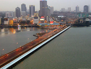 The Johor-Singapore Causeway as viewed from the Woodlands Checkpoint in Singapore towards Johor Bahru, Malaysia. The end of Singaporean territory and start of Malaysian territory can be clearly seen with the differences in road surface and markings near the mid-section of the Causeway.
The Malaysia–Singapore border is an international maritime border between the Southeast Asian countries of Malaysia, which lies to the north of the border, and Singapore to the south. The boundary is to a large extent formed by straight lines between maritime geographical coordinates running along or near the deepest channel of the Straits of Johor (Malay: Selat Tebrau).[1]
The western portion of the border beyond that delimited by the 1995 agreement goes into the western section of the Singapore Straits while the eastern portion of the border beyond the eastern terminus of the defined border continues into the eastern section of the Singapore Straits. Outside the border defined by the 1995 agreement, there is still no formal agreement between the two countries to delimit their common borders and this has resulted in several overlapping claims. Singapore claims a three nautical mile (6 km) territorial sea limit, while Malaysia claims a 12-nautical-mile (22 km) territorial sea limit.
Following the International Court of Justice decision on 23 May 2008 on the sovereignty of Pedra Branca which gave the island to Singapore, the new portion of the Malaysia-Singapore maritime border around the island will also need to be determined. The island lies 24 nautical miles (44 km) or 44 km east from the eastern most point of Singapore, and 7.7 nautical miles (14.3 km) or 14.2 km southeast of the Malaysian coastline.
There is also a dispute involving the alleged incursion into Malaysian territorial waters by land reclamation works by Singapore at the western entrance to the Straits of Johor.
There are two structural crossings along the border. They are the Johor-Singapore Causeway and the Malaysia-Singapore Second Link (as known in Malaysia), or the Tuas Second Link (as known in Singapore). There is also an international ferry service between Pengarang at the southeastern tip of Johor and Changi Village at the eastern of the island.
Contents
The border
Delimited boundary
A large extent of the Malaysia–Singapore border is defined by the Agreement between the Government of Malaysia and the Government of the Republic of Singapore to delimit precisely the territorial waters boundary in accordance with the Straits Settlement and Johore Territorial Waters Agreement 1927 as being straight lines joining a series of 72 geographical coordinates roughly running about 50 nautical miles (93 km) along the deepest channel (thalweg) between the western and eastern entrances of the Straits of Johor. This delineation was arrived at and agreed to jointly by the two governments and resulted in the agreement being signed on 7 August 1995.[2]
The coordinates, which are stated in Annex 1 of the agreement, are as follows:
Point Latitude Longitude Point Latitude Longitude Point Latitude Longitude East of Johor-Singapore Causeway E1 01° 27' 10.0" 103° 46' 16.0" E17 01° 25' 49.5" 103° 56' 00.3" E33 01° 26' 38.0" 104° 02' 27.0" E2 01° 27' 54.5" 103° 47' 25.7" E18 01° 25' 49.7" 103° 56' 15.7" E34 01° 26' 23.5" 104° 03' 26.9" E3 01° 28' 35.4" 103° 48' 13.2" E19 01° 25' 40.2" 103° 56' 33.1" E35 01° 26' 04.7" 104° 04' 16.3" E4 01° 28' 42.5" 103° 48' 45.6" E20 01° 25' 31.3" 103° 57' 09.1" E36 01° 25' 51.2" 104° 04' 35.3" E5 01° 28' 36.1" 103° 49' 19.8" E21 01° 25' 27.9" 103° 57' 27.2" E37 01° 25' 03.3" 104° 05' 18.5" E6 01° 28' 22.8" 103° 50' 03.0" E22 01° 25' 19.8" 103° 58' 20.7" E38 01° 24' 55.8" 104° 05' 22.6" E7 01° 27' 58.2" 103° 51' 07.2" E23 01° 25' 19.0" 103° 58' 00.5" E39 01° 24' 44.8" 104° 05' 26.7" E8 01° 27' 46.6" 103° 51' 31.2" E24 01° 25' 19.0" 103° 58' 20.7" E40 01° 24' 21.4" 104° 05' 33.6" E9 01° 27' 31.9" 103° 51' 53.9" E25 01° 25' 27.9" 103° 58' 47.7" E41 01° 23' 59.3" 104° 05' 34.9" E10 01° 27' 23.5" 103° 52' 05.4" E26 01° 25' 27.4" 103° 59' 00.9" E42 01° 23' 39.3" 104° 05' 32.9" E11 01° 26' 56.3" 103° 52' 30.1" E27 01° 25' 29.7" 103° 59' 10.2" E43 01° 23' 04.9" 104° 05' 22.4" E12 01° 26' 06.5" 103° 53' 10.1" E28 01° 25' 29.2" 103° 59' 20.5" E44 01° 22' 07.5" 104° 05' 00.9" E13 01° 25' 40.6" 103° 53' 52.3" E29 01° 25' 30.0" 103° 59' 34.5" E45 01° 21' 27.0" 104° 04' 47.0" E14 01° 25' 39.1" 103° 54' 45.9" E30 01° 25' 25.3" 103° 59' 42.9" E46 01° 20' 48.0" 104° 05' 07.0" E15 01° 25' 36.0" 103° 55' 00.6" E31 01° 25' 14.2 104° 00' 10.3" E47 01° 17' 21.3" 104° 07' 34.0" E16 01° 25' 41.7" 103° 55' 24.0" E32 01° 26' 20.9" 104° 01' 23.9" West of Johor-Singapore Causeway W1 01° 27' 09.8" 103° 46' 15.7" W10 01° 26' 14.1" 103° 41' 00.0" W19 01° 21' 26.6" 103° 28' 15.5" W2 01° 26' 54.2" 103° 45' 38.5" W11 01° 25' 41.3" 103° 40' 26.0" W20 01° 21' 07.3" 103° 38' 08.0" W3 01° 27' 01.4" 103° 44' 48.4" W12 01° 24' 56.7" 103° 40' 10.0" W21 01° 20' 27.8" 103° 37' 48.2" W4 01° 27' 16.6" 103° 44' 23.3" W13 01° 24' 37.7" 103° 39' 50.1" W22 01° 19' 17.8" 103° 37' 04.2" W5 01° 27' 36.5" 103° 43' 42.0" W14 01° 24' 01.5" 103° 39' 25.8" W23 01° 18' 55.5" 103° 37' 01.5" W6 01° 27' 26.9" 103° 42' 50.8" W15 01° 23' 28.6" 103° 39' 12.6" W24 01° 18' 51.5" 103° 36' 58.2" W7 01° 27' 02.8" 103° 42' 13.5" W16 01° 23' 13.5" 103° 39' 10.7" W25 01° 15' 51.0" 103° 36' 10.3" W8 01° 26' 35.9" 103° 41' 55.9" W17 01° 22' 47.7" 103° 38' 57.1" W9 01° 26' 23.6" 103° 41' 38.6" W18 01° 21' 46.7" 103° 38' 27.2" The Straits Settlement and Johore Territorial Waters Agreement of 1927 signed between the Britain and the Sultanate of Johor on 19 October 1927, defines the territorial sea border between Malaysia and Singapore as:
- "... an imaginary line following the centre of the deep-water channel in Johore Strait, between the mainland of the State and Territory of Johore on the one side, and the northern shores of the islands of Singapore, Pulau Ubin, Pulau Tekong Kechil, and Pulau Tekong Besar on the other side. Where, if at all, the channel divides into two portions of equal depth running side by side, the boundary shall run midway between these two portions. At the western entrance of Johore Strait, the boundary, after passing through the centre of the deep-water channel eastward of Pulau Merambong, shall proceed seaward, in the general direction of the axis of this channel produced, until it intersects the 3-mile (4.8 km) limit drawn from the low water mark of the south coast of Pulau Merambong. At the Eastern entrance of Johore Strait, the boundary shall be held to pass through the centre of the deep-water channel between the mainland of Johore, westward of Johore Hill, and Pulau Tekong Besar, next through the centre of the deep-water channel between Johore Shoal and the mainland of Johore, southward of Johore Hill, and finally turning southward, to intersect the 3-mile (4.8 km) limit drawn from the low water mark of the mainland of Johore in a position bearing 192 degrees from Tanjong Sitapa."[3]
The boundary drawn by the 1995 agreement follows closely but, by virtue of being straight lines between points, does not exactly correspond with the deepest channel of the Straits of Johor as described in the 1927 agreement. As the 1995 agreement supersedes the 1927 agreement as far as any inconsistency goes, the thalweg method of determining the precise borderline is therefore replaced with the use of geographical coordinates. The 1995 agreement also states that the border will be final and, therefore, not be influenced by any variation of the depth or alignment of the deepest channel of the Straits of Johor. This is important considering frequent reclamation activities by both Malaysia and Singapore in the Straits of Johor which could alter the depth of the waterway.
Undetermined boundaries
The border outside the points agreed to in the 1995 agreement has not been determined and is subject to some level of contention. In 1979, Malaysia published a map[4] unilaterally defining its territorial waters and continental shelf, and "picks up" from where the 1927 agreement left off as far as the Malaysia–Singapore border is concerned.
Western segment
According to the 1979 map, on the western entrance to the Straits of Johor, the border stars at "Point 21", which lies near the western terminus of the border as defined by the 1927 agreement and the terminus of the border agreed to in the 1995 agreement (knowns as Point W25). The Malaysian border then extends southwards until "Point 17" where it then goes northeasterly till it meets the southern terminus of the Indonesia-Malaysia border delimited by the Indonesia-Malaysia continental shelf boundary agreement of 1969 and the Indonesia-Malaysia territorial waters agreement of 1971. The border between Malaysia and Singapore only runs part of the way between Point 21 and Point 15 where it should intersect the Indonesia-Singapore maritime border. The meeting point of the territorial sea of the three countries however has not been determined.
Point Longitude (E) Latitude (N) Remarks Turning points along the continuation of Malaysia's maritime border to the west of Singapore as in its 1979 map 15 103° 22'.8 1° 15'.0 Same as Point 10 (southern terminus) of the continental shelf boundary and Point 8 of the territorial sea boundary 16 103° 26'.8 1° 13'.45 This turning point may form part of the Indonesia-Malaysia border 17 103° 32'.5 1° 1'.45 This turning point may form part of the Indonesia-Malaysia border 18 103° 34'.2 1° 11'.0 This turning point may form part of the Indonesia-Malaysia border 19 103° 34'.95 1° 15'.15 20 103° 37'.38 1° 16'.37 21 103° 36'.1 1° 15'.85 This point lies close but does not correspond with Point W25 of the 1995 territorial waters agreement Eastern segment
The eastern continuation of the territorial waters border defined by the 1979 Malaysian map starts near the eastern terminus of the 1927 agreement border at "Point 22", whereby it suddenly goes westwards towards Singapore to Point 23 before travelling southeasterly towards its southmost point at Point 27. It then continues in a general easterly direction to meet the southern terminus of the Indonesia-Malaysia border as defined by their continental shelf boundary agreement of 1969. The Indonesia-Singapore border should intersect this boundary at some point but the meeting point of the maritime territories of the three countries has not been determined.
Point Longitude (E) Latitude (N) Remarks Turning point coordinates along the continuation of Malaysia's maritime border to the east of Singapore as in its 1979 map 22 104° 7'.5 1° 17'.63 This point lies close but does not correspond with Point E47 of the 1995 territorial waters agreement 23 104° 2'.5 1° 17'.42 This turning point may form part of the Indonesia-Malaysia border 24 104° 4'.6 1° 17'.3 This turning point may form part of the Indonesia-Malaysia border 25 104° 7'.1 1° 16'.2 This turning point may form part of the Indonesia-Malaysia border 26 104° 7'.42 1° 15'.65 This turning point may form part of the Indonesia-Malaysia border 27 104° 12'.67 1° 13'.65 This turning point may form part of the Indonesia-Malaysia border 28 104° 16'.15 1° 16'.2 This turning point may form part of the Indonesia-Malaysia border 29 104° 19'.8 1° 16'.5 This turning point may form part of the Indonesia-Malaysia border 30 104° 29'.45 1° 15'.55 This turning point may form part of the Indonesia-Malaysia border 31 104° 29'.33 1° 16'.95 This turning point may form part of the Indonesia-Malaysia border 32 104° 29'.5 1° 23'.9 This point is the same as Point 11 (southern terminus) of the 1969 Indonesia-Malaysia continental shelf boundary Malaysia's maritime boundary in its 1979 map is not recognised by Singapore[5] and Singapore disputes many parts of the territorial sea and continuental shelf claimed by Malaysia. Among them is a slice of territorial waters called the "Point 20 sliver" (see below), and previously, the sovereignty of Pulau Batu Puteh/Pedra Branca which lies within the 12-nautical-mile (22 km) territorial waters claimed by Malaysia but has since been decided by the International Court of Justice in Singapore's favour.
With the award to Singapore of the sovereignty of the island, further determination of the maritime boundary between the two countries as well as with Indonesia whose territorial waters are also in the area, would have to be done to fill in the various gaps and determine the tripoints.
The area around Pedra Branca is expected to be complicated. Pedra Branca lies beyond the three nautical mile (6 km) zone claimed by Singapore but within the 12-nautical-mile (22 km) zone claimed by Malaysia. Singapore has indicated that the Indonesia-Singapore and Malaysia–Singapore borders in this area would not run continuously from the waters adjacent to the main Singapore island to the Pedra Branca area and a stretch of the Indonesia-Malaysia border would lie in between.[6] Further complications could arise by the awarding of Middle Rocks, which lies 0.6 nautical miles (1.5 km) south of Pedra Branca (i.e away from the Johor coast), to Malaysia. A joint technical committee has been formed to determine the maritime border.[7]
History
The border between Malaysia and Singapore only came into existence in the 19th century with the establishment and subsequent of cession of the island to the British East India Company by the Sultanate of Johor in 1824. Prior to that, Singapore was an integral part of the Johor Sultanate and subsequently, the Johor-Riau Sultanate.
The border changed from being an international border to a sub-national boundary (boundary of a division within a country) and vice-versa several times. It became an international border after the cession of Singapore to the East India Company by Johor in 1824 as Johor was de jure a sovereign state. In 1914, the border became that of between two British-ruled territories when Johor became a British protectorate while Singapore remained a British crown colony.
On 31 August 1957, the Federation of Malaya (which consisted of only Peninsular Malaysia), which included Johor as a component state, became independent and the Johor-Singapore border again became an international boundary between the sovereign state of Malaya and the self-governing British territory of Singapore. On 16 September 1963, Singapore merged with and become a component state of the Federation of Malaysia, rendering the border one between two component states of Malaysia. The border again became an international border when Singapore separated from Malaysia on 9 August 1965 to become an independent, sovereign nation.
Disputes
The Malaysian and Singaporean governments have been involved in a range of disputes and disagreements which have tested the bilateral relations between the two countries. Most of these, including that over Keretapi Tanah Melayu, or Malayan Railway, land in Singapore, are not territorial or border disputes as they do not involve questions of sovereignty over territory or territorial waters.
There have, however, been two disputes concerning sovereignty of territory along the Malaysia–Singapore border. The more well-known one is that over Pedra Branca, which the International Court of Justice decided in Singapore's favour on 23 May 2008. Another case arose from a "complaint" by Malaysia over reclamation carried out by Singapore at territorial waters adjacent to the border with Malaysia. The dispute was submitted to the International Tribunal for the Law of the Sea in Hamburg by Malaysia on 4 September 2003.
Sovereignty of Pedra Branca/Pulau Batu Puteh
Main article: Pedra Branca disputePedra Branca (as the island is known in Singapore) or Pulau Batu Puteh (as it is known in Malaysia) is an island located at the eastern entrance to the Singapore Straits to the southeast of the southeastern tip of Johor, Malaysia. Together with two other marine features called Middle Rocks and South Ledge, they were subject to a sovereignty dispute between Malaysia and Singapore. On 23 May 2008, the International Court of Justice decided that Singapore had sovereignty over Pedra Branca while Malaysia had sovereignty over Middle Rocks. It left the question of sovereignty over South Ledge, which only appears during low tide, to be determined later by stating that its sovereignty would depend on whose territorial waters it was located in. The decision settles a long-standing barrier to the negotiation process for the determination of the maritime boundary between the two countries and both Malaysia and Singapore said immediately after the ICJ decision that a joint technical committee would be set up to determine the maritime border in the waters around Pedra Branca.
Singaporean land reclamation case
This dispute resulted from reclamation works carried out by Singapore in two areas, namely in the southwestern end of the island called the Tuas development, and in the waters adjacent to Pulau Tekong in the Straits of Johor. The latter does not involve any encroachment into the territorial waters of Malaysia, and Malaysia merely argued that the reclamation works would affect the environment of the Straits of Johor as a shared waterway.
The Tuas development, however, can be deemed a case of territorial dispute as Malaysia claims the reclamation works has encroached into its territorial waters in an area called the "Point 20 sliver".[8] The "sliver", regarded as an anomaly by Singapore, arises as a result of the unilateral declaration of Malaysia's territorial waters boundary as defined by a 1979 map published by Malaysia where, between turning points No 19 and No 21, Point 20 strikes out to the east of the general continental shelf boundary towards Singapore, thus forming a triangle of Malaysian territorial waters extending eastwards from the general north-south territorial waters boundary. The Tuas development reclamation project encroaches into this sliver of territorial waters. Singapore does not recognise the 1979 continental shelf boundary and, thus, does not recognise the "point 20 sliver" as under Malaysian sovereignty.[9]
In 2003, Malaysia submitted a case to the International Tribunal for the Law of the Sea and requested for provisional measures against Singapore's reclamation works, including that concerning Point 20. On 8 October 2003, the tribunal decided that:
- Malaysia has not shown that there is a situation of urgency or that there is a risk that its rights with respect to an area of its territorial sea would suffer irreversible damage pending consideration of the merits of the case by the arbitral tribunal. Therefore, the Tribunal does not consider it appropriate to prescribe provisional measures with respect to the land reclamation by Singapore in the sector of Tuas.[10]
Border crossings
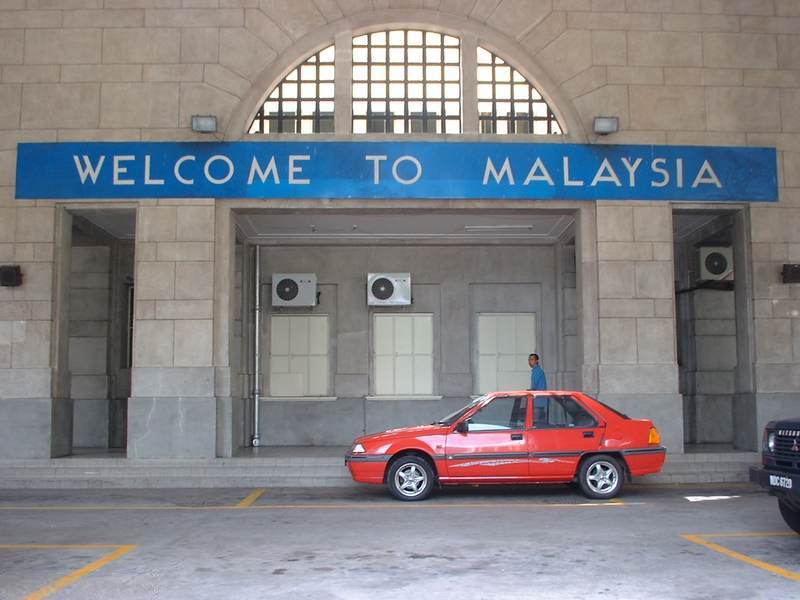
 This "Welcome to Malaysia" sign at the entrance of Tanjong Pagar Railway Station was removed in 2004. The station as well as all the land on which the railway is built, although owned by Malaysia, are located within Singapore's sovereign territory, and not Malaysia's.
There are two border crossings which are physical structures across the Straits of Johor, namely the Johor-Singapore Causeway and the Malaysia-Singapore Second Link (known officially as Tuas Second Link in Singapore, Linkedua in Malaysia). Besides the two road crossings, there is also a sea crossing between Pengerang in Johor and Changi in Singapore. There is also the unique Tanjong Pagar railway station/Woodlands Train Checkpoint "crossing", an anomaly which resulted from colonial rule in Malaysia and Singapore.
Johor-Singapore Causeway
Construction of the Johor-Singapore Causeway was completed in 1923 and besides a road, it also has a railway line allowing the Malayan Railway network to terminate at Tanjong Pagar in the southern part of Singapore. Checkpoints for identity card checks were set up in 1966, and passport checks began in 1967.[11] Malaysian immigration is located on the Johor Bahru side (where there are several checkpoints, namely the Johor Bahru Causeway for private vehicles, and Tanjung Puteri for commercial vehicles like buses and trucks), while Singaporean immigration is located on the Woodlands side of the causeway.
Malaysia-Singapore Second Link
The Second Link, the second border crossing between the two countries, connects Tuas on the Singaporean side to Tanjung Kupang on the Malaysian side, was completed and opened to traffic on 2 January 1998.
Changi Point-Pengerang sea crossing
There is also a sea crossing between Malaysia and Singapore between Pengerang in the southeastern tip of Johor and Changi Point near Changi Village in the northeastern tip of Singapore. The Singapore immigration post in Changi Point was set up in November 1967.[12]
Tanjong Pagar Railway Station and the Woodlands Train Checkpoint
Another border crossing between Malaysia and Singapore can be said to exist at the Tanjong Pagar Railway Station on Keppel Road in Singapore. Although located away from the actual physical border and deep in Singaporean territory, Tanjong Pagar Railway Station used to be the processing point for passengers leaving or entering Singapore to or from Malaysia by train. The station used to house both Malaysian and Singaporean customs, immigration and quarantine (CIQ). This changed on 1 August 1998 when Singapore closed its CIQ checkpoint at the station and moved it to the Woodlands Train Checkpoint which is part of the Woodlands CIQ complex located at the northern part of the island just before the Causeway. Malaysia, however, refused to move its immigration checkpoint and maintains it at the railway station, creating a bilateral relations row between the two countries.[13] This created the unusual situation where a person entering Malaysia by train gets processed first for entering Malaysia by Malaysian immigration at the railway station, before being processed for exiting Singapore by Singaporean immigration at Woodlands. For a person entering Singapore by train, Malaysian immigration procedures are carried out on the train in Johor Bahru while Singaporean immigration procedures are done at the Woodlands checkpoint; therefore, passengers arriving at Tanjong Pagar no longer have to go through immigration at the railway station. Passengers may even choose to disembark at Woodlands after clearing Singaporean immigration.
On 24 May 2010, Malaysia and Singapore agreed to relocate the station and Malaysia's CIQ to the Woodlands Train Checkpoint.[14][15]
For more, see Malaysia–Singapore Points of Agreement of 1990.
See also
- Indonesia–Malaysia border
- Indonesia–Singapore border
- Pedra Branca
- Malaysia
- Singapore
References
- ^ Agreement between the Government of Malaysia and the Government of the Republic of Singapore to delimit precisely the territorial waters boundary in accordance with the Straits Settlement and Johor Territorial Waters Agreement 1927, signed on 7 August 1995.
- ^ Charney, Jonathan I (2005). International Maritine Boundaries. Martinus Nijhoff Publishers. pp. 2345–56. ISBN 9041103457. http://books.google.com/books?id=XkgfZJjh3BUC&pg=PA2345&lpg=PA2345&dq=straits+settlements+and+johor+territorial+waters+agreement&source=web&ots=7W78KslwTR&sig=hDVcGQCK3vNA_gvQjf0Ht_CygRc#PPA2356,M1.
- ^ The agreement appears as a schedule in Singapore's Straits Settlements and Johore Territorial Waters (Agreement) Act 1928.
- ^ See map reproduced by the Singapore Ministry of Foreign Affairs in the country's response in the International Tribunal of the Law of the Sea case concerning the reclamation of lands by Singapore in the Straits of Johor.
- ^ Sovereignty over Pedra Branca/Pulau Batu Puteh, Middle Rocks and South Ledge (Malaysia/Singapore), 1 Memorial of Singapore, p22 (International Court of Justice 2004).
- ^ Transcript of Press Conference by Minister for Foreign Affairs George Yeo and Indonesia Foreign Minister Hassan Wirajuda, DEPLU, Gedung Pancasila, 10 March 2009, 10 March 2009, http://app.mfa.gov.sg/2006/press/view_press.asp?post_id=4872, retrieved 2009-03-13
- ^ Mahavera, Sheridan (24 May 2008), "Legal implications 'to be studied'", New Straits Times: 4
- ^ See map1 and map2 of "point 20" reproduced in Case concerning Land Reclamation by Singapore in and around the Straits of Johor (Malaysia v. Singapore), Provisional Measures, Case 12, Response of Singapore (International Tribunal for the Law of the Sea 2003).
- ^ Case concerning Land Reclamation by Singapore in and around the Straits of Johor (Malaysia v. Singapore), Provisional Measures, Case 12, Response of Singapore (International Tribunal for the Law of the Sea 2003).
- ^ "Order in the case concerning land reclamation by Singapore in and around the Straits of Johor (Malaysia v. Singapore)" (PDF) (Press release). International Tribunal for the Law of the Sea. 8 October 2003. http://www.itlos.org/news/press_release/2003/press_release_84_en.pdf. Retrieved 2008-05-27.
- ^ ([dead link]) History of Singapore Immigration, archived from the original on 2007-09-28, http://web.archive.org/web/20070928045952/http://app.ica.gov.sg/about_ica/heritage/history_sir/immigration.asp, retrieved 2008-03-19
- ^ ([dead link]) History of Our Checkpoints, archived from the original on June 21, 2007, http://web.archive.org/web/20070621154554/http://app.ica.gov.sg/about_ica/heritage/history_sir/checkpoints.asp, retrieved 2008-03-03
- ^ "Tanjong Pagar: Talks 'break down'", New Straits Times: 1, 7, 31 July 1998
- ^ Joint statement by Prime Minister Lee Hsien Loong and Prime Minister Dato' Sri Mohd Najib Tun Abdul Razak at the Singapore-Malaysia Leaders' Retreat on 24 May 2010, 24 May 2010, http://www.news.gov.sg/public/sgpc/en/media_releases/agencies/micacsd/press_release/P-20100524-1.html, retrieved 2010-05-25
- ^ "KTMB station in Tanjong Pagar to relocate to Woodlands by Jul 2011". Channel NewsAsia. 24 May 2010. http://www.channelnewsasia.com/stories/singaporelocalnews/view/1058645/1/.html.
Categories:

Wikimedia Foundation. 2010.