- Malmsmead
-
Coordinates: 51°13′01″N 3°43′59″W / 51.217°N 3.733°W
Malmsmead 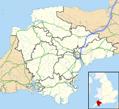
 Malmsmead
Malmsmead shown within DevonOS grid reference SS7903747813 Parish Oare Unitary authority North Devon Ceremonial county Devon Region South West Country England Sovereign state United Kingdom Post town LYNTON Postcode district EX35 6 Police Devon and Cornwall Fire Devon and Somerset Ambulance South Western EU Parliament South West England List of places: UK • England • Devon Malmsmead is a hamlet in the civil parish of Oare in the North Devon district of Devon, England. Its nearest town is Lynton, which lies approximately 4.7 miles (7.6 km) west from the hamlet. The hamlet is situated on the Devon-Somerset border in the Doone Valley of the Exmoor National Park.[1]
References
Towns and villages in North Devon 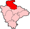 Barbrook · Barnstaple · Berrynarbor · Braunton · Charles · Colleton · Combe Martin · Creacombe · Croyde · East Anstey · East Buckland · Filleigh · Fremington · Furzehill · Georgeham · Hele Bay · Ilfracombe · Instow · Kentisbury · Knowle · Knowstone · Landkey · Lee · Lee Bay · Lynmouth · Lynton · Malmsmead · Meshaw · Mortehoe · Oldways End · Parracombe · Rackenford · Roachill · Saunton · Shallowford · Week · West Down · West Lynn · Westward Ho! · Woolacombe · Wrafton · YellandCategories:
- Hamlets in Devon


Wikimedia Foundation. 2010.