- Balmoral (District Electoral Area)
-
Balmoral
District Electoral Area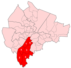
Map showing Balmoral wards within BelfastArea 13.71 km2 (5.29 sq mi) Population 29,681 (2008 Estimate) - Density 2,165 /km2 (5,610 /sq mi) District Belfast City Council County County Antrim Country Northern Ireland Sovereign state United Kingdom EU Parliament Northern Ireland UK Parliament Belfast South NI Assembly Belfast South List of places: UK • Northern Ireland • Antrim Balmoral is the most southern of nine district electoral areas (DEA) in Belfast, Northern Ireland. The district elects six members to Belfast City Council and contains the wards of Blackstaff; Finaghy; Malone; Musgrave; Upper Malone and Windsor. Balmoral, along with neighbouring Laganbank, forms the greater part of the Belfast South constituencies for the Northern Ireland Assembly and UK Parliament.
The district is bound to the west and south west by the M1 Motorway, to east and south east by the River Lagan, to the east and north east by the Malone Road and to the north by Belfast City Hospital, Queen's University Belfast and Royal Victoria Hospital.
The Lisburn Road is the main arterial route through the centre of the district, which also contains a number of public facilities including: the King's Hall conference and exhibition centre, the Musgrave Park Hospital, Sir Thomas and Lady Dixon Park and Windsor Park, the home ground of the Northern Ireland national football team. It is served by the Adelaide, Balmoral and Finaghy railway stations.
Contents
History
The DEA was created for the 1985 local elections, where it contained five wards. Four of the wards came from the abolished Area C, which it effectively replaced, with the final ward, Blackstaff, coming from Area F. From the 1993 local elections onwards, the area has contained six wards, following the creation of the Musgrave ward.
Wards
Map Ward Population
(2008 Estimate)Population
(2001 Census)Catholic Protestant Other Area Density NI Assembly UK Parliament Ref 1 Blackstaff 3,673 3,964 4.2% 91.4% 4.4% 1.92 km2 2,065/km2 Belfast South Belfast South [1] 2 Finaghy 4,468 4,994 44.6% 49.8% 5.6% 2.59 km2 1,928/km2 Belfast South Belfast South [2] 3 Malone 5,249 5,694 55.9% 37.8% 6.3% 2.18 km2 2,612/km2 Belfast South Belfast South [3] 4 Musgrave 4,795 5,277 59.7% 36.5% 3.8% 1.78 km2 2,965/km2 Belfast South Belfast South [4] 5 Upper Malone 4,567 4,926 24.7% 69.1% 6.2% 4.32 km2 1,140/km2 Belfast South Belfast South [5] 6 Windsor 6,929 7,087 43.4% 47.4% 9.2% 0.92 km2 7,703/km2 Belfast South Belfast South [6] Balmoral 29,681 31,942 40.8% 53.0% 6.2% 13.71 km2 2,330/km2 Councillors
 The King's Hall is a multi-purpose venue located in Balmoral.
Election Councillor
(Party)Councillor
(Party)Councillor
(Party)Councillor
(Party)Councillor
(Party)Councillor
(Party)2011 Tom Ekin
(Alliance Party)Claire Hanna
(SDLP)Bernie Kelly
(SDLP)Máirtín Ó Muilleoir
(Sinn Féin)Ruth Patterson
(DUP)Bob Stoker
(UUP)2005 Carmel Hanna
(SDLP)Jim Kirkpatrick
(DUP)2001 Catherine Molloy
(SDLP)Margaret Crooks
(UUP)1997 Harry Smith
(DUP)1993 Philip McGarry
(Alliance Party)Dorita Field
(SDLP)Harry Smith
(DUP)Joan Parkes
(DUP)Jim Kirkpatrick
(UUP)1989 Mark Long
(Alliance Party)Additional seat from 1993 1985 John Montgomery
(Alliance Party)Billy Dickson
(DUP)In May 2011, Councillors Tom Ekin, Ruth Patterson and Bob Stoker were appointed as Aldermen by Belfast City Council. Alderman Ruth Patterson also served as Deputy Lord Mayor, 2011–12.
2011 Elections
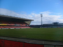 Windsor Park is the home of the Northern Ireland football team.
Belfast City Council elections, 2011[7] Party Candidate 1st Pref Alliance Tom Ekin 1,762 Democratic Unionist Ruth Patterson 1,553 Sinn Féin Máirtín Ó Muilleoir 1,465 SDLP Claire Hanna 1,443 Ulster Unionist Bob Stoker 922 SDLP Niall Kelly 743 SDLP Bernie Kelly 706 Ulster Unionist Jim Kirkpatrick 578 Democratic Unionist Sharon Simpson 396 Green (NI) Mark Simpson 282 People Before Profit Andrew King 107 Turnout 9,957 Sinn Féin gain from Democratic Unionist See also
- Belfast City Council
- Electoral wards of Belfast
- Local government in Northern Ireland
- Members of Belfast City Council
References
- ^ "Ward Information for Blackstaff ward 95GG10". NISRA. http://www.ninis.nisra.gov.uk/mapxtreme/pf_report.asp?sLevel=WARD&sID=95GG10&sName=Blackstaff. Retrieved 13 June 2011.
- ^ "Ward Information for Finaghy ward 95GG23". NISRA. http://www.ninis.nisra.gov.uk/mapxtreme/pf_report.asp?sLevel=WARD&sID=95GG23&sName=Finaghy. Retrieved 13 June 2011.
- ^ "Ward Information for Malone ward 95GG33". NISRA. http://www.ninis.nisra.gov.uk/mapxtreme/pf_report.asp?sLevel=WARD&sID=95GG33&sName=Malone. Retrieved 13 June 2011.
- ^ "Ward Information for Musgrave ward 95GG34". NISRA. http://www.ninis.nisra.gov.uk/mapxtreme/pf_report.asp?sLevel=WARD&sID=95GG34&sName=Musgrave. Retrieved 13 June 2011.
- ^ "Ward Information for Upper Malone ward 95GG45". NISRA. http://www.ninis.nisra.gov.uk/mapxtreme/pf_report.asp?sLevel=WARD&sID=95GG45&sName=Upper%20Malone. Retrieved 13 June 2011.
- ^ "Ward Information for Windsor ward 95GG49". NISRA. http://www.ninis.nisra.gov.uk/mapxtreme/pf_report.asp?sLevel=WARD&sID=95GG49&sName=Windsor. Retrieved 13 June 2011.
- ^ Elections 2011: Balmoral, Belfast City Council

Upper Falls Lower Falls Laganbank Upper Falls 
Laganbank  Balmoral

Lisburn City Council Lisburn City Council Lisburn City Council Belfast City Council General 
People District Electoral Areas Amenities Parks and gardens Cemeteries Balmoral Cemetery • Belfast City Cemetery • Clifton Street Cemetery • Roselawn CemeteryElections See also: Local government in Northern Ireland • CategoryCategories:- Electoral wards of Belfast


Wikimedia Foundation. 2010.