- Greater Manchester Statutory City Region
-
For the metropolitan county of North West England, see Greater Manchester.
The Greater Manchester Statutory City Region[1][2] (sometimes called the Greater Manchester City Region[3][4][5] or more commonly as the Manchester City Region) is a pilot administrative division of England, coterminous with the metropolitan county of Greater Manchester. It is under the strategic governance of the Greater Manchester Combined Authority.
The Manchester City Region initially appeared as one of eight city regions defined in the 2004 strategic document Moving Forward: The Northern Way,[6] as a collaboration between three regional development agencies. It encompassed the ten districts of Greater Manchester and five neighbouring local government districts,[3] and was suggested as an effective administrative metropolitan area that could share resources and stimulate economic growth in northern England. In the late 2000s, the Association of Greater Manchester Authorities (AGMA) began actively lobbying for a statutory local government framework for the Manchester City Region in exchange for greater autonomy from the UK central government.[4] They used the term 'Manchester City Region' as a synonym for 'Greater Manchester' (a metropolitan county), and excluded neighbouring districts.[7] Following the 2009 United Kingdom Budget, the city region—abridged to the ten districts of Greater Manchester—was announced as a pilot region which could establish a formal corporate strategic government with powers comparable with the Greater London Authority. AGMA agreed to the creation of the Greater Manchester Combined Authority in March 2010; on 1 April 2011 the combined authority was established.
History
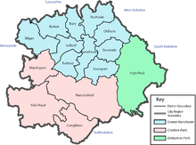 A map of the Manchester City Region as it was defined in 2004.
Between the publication of the Moving Forward: The Northern Way in 2004, through to the 2009 structural changes to local government in England, the Manchester City Region encompassed fifteen local government districts: the cities of Manchester and Salford plus the adjoining metropolitan boroughs of Stockport, Tameside and Trafford to the south and Bolton, Bury, Oldham, Rochdale and Wigan to the north, together with High Peak, Warrington and the former boroughs of Congleton, Macclesfield and Vale Royal.[3] The inclusion of these five areas added 656,355 inhabitants to the 2,562,200 already in Greater Manchester creating a city region of 3,218,555 using figures from the United Kingdom Census 2001.[8]
Since the 2009 structural changes to local government in England, the Association of Greater Manchester Authorities has used the term 'Manchester City Region' as a synonym for Greater Manchester, describing it as "a highly coherent single economic region", with reference to the "ten districts of the city region".[7] AGMA have published that in their literature "‘Manchester’ and ‘city region’ are used to refer to Greater Manchester, which is the ten local authority Districts of Bolton, Bury, Oldham, Manchester, Rochdale, Stockport, Salford, Tameside, Trafford and Wigan".[9]
The Greater Manchester Statutory City Region was announced in the 2009 United Kingdom Budget as one of two such pilot city regions in the UK (the other being the Leeds City Region).[10] Once created, it saw the ten metropolitan borough councils of Greater Manchester banding together as a combined authority to pool resources over skills, housing, transport and economic development, in exchange for greater powers from the UK central government.[11]
See also
- Greater Manchester Combined Authority
- Greater Manchester County Council (1974-1986)
References
- ^ Oldham Council (2010-02-16). "Greater Manchester Statutory City Region - Governance Arrangements". oldham.gov.uk. http://www.oldham.gov.uk/contrast/council/search_agendas.htm?docrefno=10020116. Retrieved 2010-03-12.
- ^ "The Manchester Statutory City Region" (PDF). agma.gov.uk. 2009-12-28. http://www.agma.gov.uk/cms_media/files/4_the_manchester_city_region.pdf. Retrieved 2010-03-12.
- ^ a b c North West Regional Assembly (2004). "Brief for the Preparation of a Sub-Regional Strategy for Greater Manchester City Region". 4nw.org.uk. http://www.4nw.org.uk/downloads/documents/imported/rp_CpdV_NWRA_Brief_for_Manchester_City.pdf. Retrieved 2010-03-11.
- ^ a b "City Region pilots". communities.gov.uk. 2009. http://www.communities.gov.uk/localgovernment/performanceframeworkpartnerships/multiareaagreements/cityregionpilots/. Retrieved 2010-03-11.[dead link]
- ^ http://www.lgcplus.com/policy-and-politics/economic-development/greater-manchester-city-region-attacked/5001943.article
- ^ Moving Forward:The Northern Way
- ^ a b Association of Greater Manchester Authorities (August 2009). "Prosperity for all: The Greater Manchester Strategy" (PDF). agma.gov.uk. http://www.agma.gov.uk/cms_media/files/final_gms_august_20091.pdf. Retrieved 2010-03-11.
- ^ "City Regions: Manchester". thenorthernway.co.uk. http://www.thenorthernway.co.uk/page.asp?id=54. Retrieved 2008-06-09.
- ^ Association of Greater Manchester Authorities (2009-07-21). "Manchester: Statutory City Region Pilot" (PDF). agma.gov.uk. http://www.agma.gov.uk/cms_media/files/4i_statutory_city_region_agreement_21_july_2009v2.pdf. Retrieved 2010-03-12.
- ^ http://downloads.bbc.co.uk/news/nol/shared/bsp/hi/pdfs/22_04_09bud09_completereport_2591.pdf
- ^ Hayman, Allister (2010-03-01). "Stockport and Trafford councils abstain from city-region vote". regen.net. http://www.regen.net/news/ByDiscipline/Economic-Development/987212/Stockport-Trafford-councils-abstain-city-region-vote/. Retrieved 2010-03-11.
Categories:- Geography of Greater Manchester
- Economy of Manchester
- City regions of England

Wikimedia Foundation. 2010.