- Mapping California
-
California is a unique place that has not always been well understood. For hundreds of years there persisted a European misconception that California was an island and many maps were made depicting it as such. Eventually, by the 18th century, enough information about California reached the outside world to dispel that myth. As California became increasingly populated, comprehensive surveying and mapping of its territory seemingly expanded slowly.
When gold was discovered in 1848 and it joined the United States as the thirty first state in 1851 interest in ploting California's landscapes boomed.
California quickly became a well documented piece of the United States. Time has brought even more mapping; with modern technology, particularly GIS any aspect of California can be and is recorded on a map. Not only are physical maps of California readily available, but maps with all variety of demographic information are as well.
 1650 Nicolas Sanson map showing California as an island.
Contents
History
Chronology of Early Surveying and Mapping Efforts
In 1841 Cadwalader Ringgold, an officer in the United States Navy, spent twenty days surveying the San Francisco Bay watershed as a member of the United States Exploring Expedition In 1849, Cadwalader Ringgold began a more comprehensive survey of surveying the San Francisco Bay region[1], the Sacramento River, and parts of the American and created a number of 8maps which included Depth sounding information for the Sacramento River and San Francisco Bay. Also included on the maps are the sizes and locations of settlements along the Sacramento River.[2] A Series of Charts with Sailing Directions, by Cadwalader Ringgold was published in 1852. This book includes the maps from the 1849 expedition as well as a color illustrations of ports and important landmarks. To further supplement the navigators the book includes notes on observed magnetic variation and a table of 26 coordinates for landmarks, harbors and a table of bearings for several point to point journeys.[3]
1857, the commanding officer of the United States Coast Survey Steamer, Active, discovers a deep submarine valley, or "gulch," in the center of Monterey Bay. This is the first known sea-floor canyon and is now called Monterey Canyon.
From the 1850s through the 1860s, the United States Coast Survey, now NOAA's Office of Coast Survey, published a set of color maps with five stratigraphic units detailing the geologic makeup of California as well as a comprehensive set of nautical charts for the entire coast of California.[4]
Shortly after statehood, the California state government appointed its first State Geologist and began commissioning geologic surveys of their own. The state appointed John B. Trask to the position of State Geologist and he served from 1850 to 1856. He compiled a report entitled "On the Geology of the Sierra Nevada, or California Range." The second State Geologist, Josiah Whitney, served from 1860 to 1873. Whitney organized the first comprehensive survey of California and the first complete topographic maps of the state were completed under him. Mount Whitney, the tallest peak in California is named after him, a testament to his legacy. The State Mining Bureau was established in 1880, and the position of State Geologist was changed to State Mineralogist. In 1891, the first state geologic map showing eight color stratigraphic regions was published. The second geologic map of the state was published in 1916 and shows twenty one stratigraphic regions. The State Mining Bureau was renamed the Division of Mines and Geology in 1862. Its pseudonym, the California Geologic Survey, was established in January 2002. [5]
In 1869, George Davidson, an assistant coast surveyor compiled the book, Pacific Coast: Coast Pilot of California, Oregon, and Washington Territory. The 262 page volume is complete with illustrations, coordinate tables, notes on magnetic variation and some bathymetric sounding information.[6]
 A bathymetric map of the Davidson Seamount, before it was named for George Davidson in 1936. Courtesy of the NOAA Image Library.
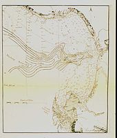 The 1897 contoured map of Monterey Bay 1897 contoured map of Monterey "Submerged Valley". From George Davidson published paper in Proc. of Calif. Acad. of Sciences. Monterey Canyon was first noted in 1857 by James Alden of C&GS Ship ACTIVE . Alden termed the canyon a "submarine gulch." Courtesy of the NOAA Image Libaray [4].
Modern Projects
Surveying efforts of California continue today with the assistance of modern technology. Modern mapping in California involves the use of modern electronics to refine information found through analog methods. Many organizations andgovernment agencies are involved in collecting and mapping data in California today.
 Modern Bathymetric chart of Monterey Canyon. Courtesy of NOAA.
Mapping Projects in California
Federal Government Agencies Mapping Projects in California
- United States Geological Survey (USGS)
- National Oceanographic and Atmospheric Administration.
- United States Department of Agriculture.
State Government Agencies Mapping Projects in California
- California Department of Fish and Game
- California Bureau of Land Management
- [http;//www.consrv.ca.gov/CGS/ California Geological Survey]
Non-Government Organizations Mapping Projects in California
- California Coastal Records Project - A photographic survey of the California Coastline, free to use. See Wikipedia article: California Coastal Records Project.
Mapping Legislation
- Alquist Priolo Special Studies Zone Act
- Surface Mining Control and Reclamation Act of 1977 (SMCRA)
- Seismic Hazards Mapping Act
General California Map Links
- Humboldt State University Library California Maps
- NOAA Office of Coast Survey Historical Map and Chart Project
- The University of Alabama Map Collection
Related Wikipedia Articles
References
- ^ Houston, Alan Fraser, "Cadwalader Ringgold, U. S. Navy" an article in California History magazine, Volume 79, Issue 4, Winter 2000, page 208.
- ^ Ringgold, Cadwalader. "Chart of the Farallons and the Entrance to San Francisco Bay..." David Rumsey Map Collection.
- ^ Ringgold, Cadwalader. A Series of Charts with Sailing Directions. J.T. Towers, 1852. Original from theNew York Public Library. Google Books [1]
- ^ Office of Coast Survey Historical Map & Chart Project, Search:"California, Nautical Charts." http://historicalcharts.noaa.gov/historicals/historical_zoom.asp
- ^ History of the California Geological Survey. State of California, Department of Conservation. [2]
- ^ Davidson, George. Pacific Coast: Coast Pilot of California, Oregon, and Washington Teriitory. Government Print Office, 1869. Google Books, [3]
External links
Bathymetric Data of the California Coast
Images of California
Map Collections
Categories:- Geography of California
- History of California
- Pre-state history of California


Wikimedia Foundation. 2010.