- Mar Oraha Monastery
-
Saint Oraha Monastery 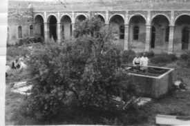
The monastery during the 1960s
Basic information Location Batnaya, Nineveh,  Iraq
IraqGeographic coordinates 36°32′41″N 43°08′44″E / 36.544722°N 43.145556°ECoordinates: 36°32′41″N 43°08′44″E / 36.544722°N 43.145556°E Affiliation Chaldean Catholic Architectural description Completed 6th century }} Saint Oraha Monastery (Syriac: ܕܝܪܐ ܕܡܪܝ ܘܪܐܗܐ), is a Chaldean Catholic monastery in northern Iraq close to the town of Batnaya.
The monastery is traditionally attributed to Saint Oraha who was forced to abandon his hermitage in Mount Alfaf due to a draught, and he descended to the plains of Nineveh where he built his monastery during Ishoʿyahb I's patriarchy (581-596).[1]
The monastery was occupied by monks of the Church of the East until 1719 when it finally passed along to the Chaldean Catholic Church. The monastery was completely destroyed and his monks were killed at the hands of Nadir Shah during his campaign in the region in 1743. In 1921 it was again rebuilt with the help of the Dominican Order.[2]
The feast of Mar Oraha is held twice at the monastery: the first Sunday of the Great Lent and the second Sunday after Easter.[3]
References
Nineveh plains Region in northern Iraq Main Settlements Al-Hamdaniya DistrictTel Keppe DistrictAin Sifni . Dashqotan . Qasrok . Ba'adra
Ancient Assyrian sites Religious sites Mar Mattai Monastery . Rabban Hormizd Monastery . Lalish . Mar Oraha Monastery . Mar Behnam MonasteryCategories:- Nineveh plains
- Christian monastery stubs
- Assyrian stubs
- Christian monasteries in Iraq
- Christian monasteries established in the 7th century
- Chaldean Catholic Church


Wikimedia Foundation. 2010.