- Mar Vista, Los Angeles
-
Mar Vista — Neighborhood of Los Angeles — Location within Western Los Angeles
 Mar Vista
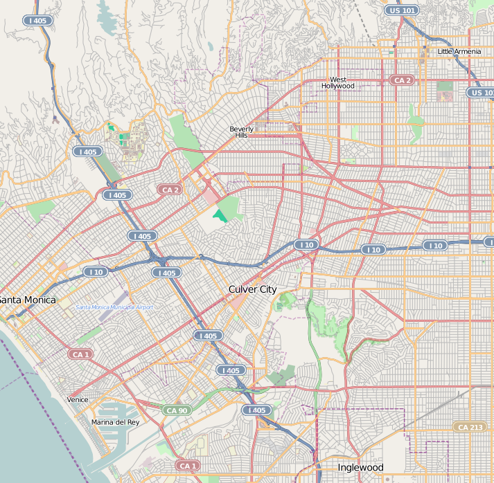
Coordinates: 34°00′17″N 118°25′48″W / 34.00472°N 118.43°W Country United States State California County Los Angeles City Los Angeles Mar Vista is a district on the West Side of Los Angeles, California.
Contents
Geography and transportation
Mar Vista is near the center of LA's West Side. The city of Santa Monica lies to the northwest, West Los Angeles to the north, Palms to the northeast, Culver City to the east, Del Rey to the southwest, and Venice to the west. Its approximate boundaries are the city limits of Culver City and the San Diego Freeway (I-405) on the northeast and southeast, Walgrove Avenue on the southwest, and the Santa Monica Municipal Airport and National Boulevard on the northwest. Major thoroughfares through the district include Washington Place; Palms, Venice, Sawtelle, Inglewood, and Grand View Boulevards; McLaughlin, Barrington, Short, and Centinela Avenues; and Beethoven Street. The district uses the 90066 ZIP code, which also serves an adjacent part of Culver City.
The Westdale area of northern Mar Vista — the area bounded by Sawtelle Boulevard, National Boulevard, Bundy Drive, and Palms Boulevard — is a neighborhood within the bounds of the Mar Vista Community Council.
History
George McCune a Mormon real estate developer, developed the area, giving streets names including Wasach and Boise, and named the area Mar Vista. McCune tried to have the Los Angeles Temple built in the area.[1]
By the early 1920s the community (then called Ocean Park Heights) was growing rapidly and saw the potential for becoming an incorporated city. In 1924, the name of the community was changed from Ocean Park Heights to Mar Vista. In 1926, Mar Vistans decided not to incorporate, but rather to be annexed to Los Angeles. Mar Vista was influenced by the fact that two neighboring cities had voted for annexation to Los Angeles, based on concern about water, and growing populations. Venice was annexed to Los Angeles in 1925, and Barnes City joined the metropolis in 1927.
The name Ocean Park Heights came from the first tract of homes built along the Venice Short Line. The tract, and the train station that served it shared the Ocean Park Heights name. This was 1904. Until 1907, the City of Venice was the City of Ocean Park. The City Hall of Ocean Park - subsequently the City Hall of Venice - was on Venice Blvd., now the Beyond Baroque Theater. Until 1907, the back country of Ocean Park with its 200-foot hill, was appropriately called Ocean Park Heights. It wasn't until 1924, that the then inappropriate name, was changed to Mar Vista.
By 1924, there were a number of tracts along Venice Blvd., and the names of several of them were proposed to replace Ocean Park Heights. These included Walnut Glen, Del Mar, Roseboro, and Hillcrest. There was a new tract north of Venice Blvd. and west of Centinela Avenue called New Mar Vista. The nearest Red Car station was named Mar Vista. After much debate, Mar Vista was selected as the name to replace Ocean Park Heights.
In 1924 Ocean Park Heights became Mar Vista, and in 1927 Mar Vista became part of the City of Los Angeles. The area annexed to Los Angeles extended north from Washington Blvd. to Pico Blvd. and from Walgrove east to Overland. Most of this area was farmland. The major crop was lima beans, which could be dry farmed. Mar Vista became known as being in the Lima Bean Belt of the Nation.
By 1912, there were four large tracts that made up Ocean Park Heights. The original Ocean Park Heights tract included Ocean View, Grand View and Mountain View streets. The East Ocean Park Tract was south of Venice Blvd. between Centinela Avenue and Inglewood Blvd. The tract east of Inglewood Avenue, which includes the new fire station and extends east to McLaughlin was Tract 928. It is the Oval tract. West of Centinela on the south side of Venice Blvd. was the Del Mar Tract. Grand View was the widest street in Los Angeles County, and the first gated community. The wide street allowed horse drawn carriages to make a u-turn, as the street dead ended at Charnock Road. The top of the hill was a dump - a dump site with the grandest views in Los Angeles County.[2]
Neighborhood
Mar Vista is an economically diverse neighborhood of apartment buildings and single-family homes. The hilly areas near its border with Santa Monica, whose spectacular ocean views give Mar Vista its name, hold some of the most expensive land in the community.
Mar Vista is considerably less densely populated than neighboring Palms, as its homeowners' associations successfully fended off the 1950s up-zoning that changed much of Palms and West Los Angeles from suburban areas to renter-dominated urban neighborhoods. It should be noted, though, that some 60 percent of the district's residents live in rental housing, owing to the density of apartment buildings on thoroughfares like Venice Boulevard and Barrington Avenue.
In recent years, the escalating cost of real estate (even a 1,500 square foot (140 m2) 1940s tract house may go for upwards of $800,000) has led to a rise in the number of newly constructed Mediterranean Revival-inspired houses on Mar Vista Hill. Nearby UCLA maintains a large graduate student housing complex along Sawtelle Boulevard near National Boulevard, as well as a smaller housing block along the north side of Venice Boulevard between Inglewood and McLaughlin Avenues.
Current Los Angeles City Council member Bill Rosendahl resides in Mar Vista. He was elected in 2005 on a slow growth platform, motivated in large part by the concerns of Mar Vista residents over traffic congestion and lost views resulting from the Playa Vista project.
The Pacific Electric Railway "Red Car" streetcars ran along Venice and Culver Boulevards during the neighborhood's early years, but were shut down after World War II.
Gregory Ain Mar Vista Tract
A portion of north-central Mar Vista, the Gregory Ain Mar Vista Tract, is designated as a Historic Preservation Overlay Zone by the city of Los Angeles. This area, built immediately after World War II, contains an abundance of excellently preserved mid-century modern architecture.[3]
Demographics
Including the small portion of Culver City within its boundaries, ZIP 90066 had a population of 55,194 as of the U.S. Census of 2000. Racial composition was 60.8% white, 4.1% black, 1% Native American, 13.5% Asian or Pacific Islander, 15.2% some other race, and 5.5% two or more races; 33.2% of respondents of all races claimed Hispanic or Latino ethnicity. Per capita income was $26,532 and median family income was $51,822; 9.7% of families and 13.9% of individuals were below the federal poverty line.
In 2009, the Los Angeles Times's "Mapping L.A." project supplied these Mar Vista statistics: population: 35,492; median household income: $62,611.[4]
Restaurant
Bars
Government and infrastructure
County, state and federal representation
The Los Angeles County Department of Health Services SPA 5 West Area Health Office serves Mar Vista.[5]
Parks and recreation
The Mar Vista Recreation Center has an auditorium, barbecue pits, an unlighted baseball diamond, lighted indoor basketball courts, lighted outdoor basketball courts, a children's play area, an indoor gymnasium without weights, an outdoor roller hockey rink, picnic tables, a lighted tennis court, an outdoor pool and a lighted volleyball court.[6]
Other
- The Mar Vista Philharmonic - the band of Arthur Barrow, Frank Zappa alumni.[citation needed]
Emergency services
The Los Angeles Fire Department operates Station 62, which serves a portion of Venice as well.
Los Angeles Police Department operates the Pacific Division Police Station, serving the neighborhood.[7]
Education
Residents are zoned to schools in the Los Angeles Unified School District. The area is within Board District 4.[8]
Elementary schools in the area include:
- Beethoven Elementary School
- Grand View Boulevard Elementary School
- Mar Vista Elementary School
- Walgrove Elementary School
All residents are zoned to:
- Mark Twain Middle School
- Daniel Webster Middle School
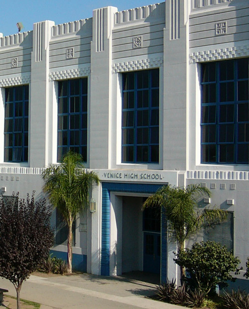
The area high school is Venice High School.
Los Angeles Public Library operates the Mar Vista Branch.[9]
Notes
- ^ Luther, Claudia (14 October 2007). "Elevated but still within buyers' reach - Los Angeles Times". Los Angeles Times. http://articles.latimes.com/2007/oct/14/realestate/re-guide14. Retrieved 14 March 2011.
- ^ Glen Howell in 2007 Mar Vista Community Directory
- ^ Gregory Ain Mar Vista Tract Historical Preservation Overlay Zone (City of Los Angeles)
- ^ "Mar Vista" entry on the Los Angeles Times "Mapping L.A." website
- ^ "About Us." Los Angeles County Department of Health Services. Retrieved on March 18, 2010.
- ^ "Mar Vista Recreation Center." City of Los Angeles. Retrieved on March 22, 2010.
- ^ http://www.lapdonline.org/pacific_community_police_station lapdonline.org
- ^ Board District 4 Map. Los Angeles Unified School District. Retrieved on November 24, 2008.
- ^ "Mar Vista Branch Library." Los Angeles Public Library. Retrieved on March 22, 2010.
External links
City of Los Angeles Topics History • Transportation • Culture • Landmarks • Historic sites • Skyscrapers • Demographics • Crime • Sports • Media • Music • Notable people • Lists
Government Flag • Mayors • City Council • Other elected officials • Airport • DWP • Fire Department • Police • Public schools • Libraries • Port • TransportationRegions Downtown • Eastside/Northeast • Harbor Area • Greater Hollywood • Westlake & Silver Lake/Los Feliz • San Fernando and Crescenta Valleys • South Los Angeles • Westside • WilshireWestside region, Los Angeles Districts and
neighborhoodsBel Air · Benedict Canyon · Beverly Crest · Beverly Glen · Beverly Hills Post Office · Beverlywood · Brentwood · Brentwood Circle · Brentwood Glen · Century City · Cheviot Hills · Crestview · Del Rey · East Gate Bel Air · Holmby Hills · Kenter Canyon · Mandeville Canyon · Marina Peninsula · Mar Vista · Palisades Highlands · Pacific Palisades · Palms · Playa del Rey · Playa Vista · Rancho Park · Rustic Canyon · Sawtelle · South Robertson · Venice · West Los Angeles · Westchester · Westdale · Westside Village · Westwood
Points of
interestSee also Downtown · Eastside/Northeast · Harbor Area · Greater Hollywood · Westlake & Silver Lake/Los Feliz · San Fernando and Crescenta Valleys · South Los Angeles · Westside · Wilshire Categories:- Neighborhoods in Los Angeles, California
- Los Angeles Historic Preservation Overlay Zones

Wikimedia Foundation. 2010.