- Washington–Rochambeau Revolutionary Route
-
 NPS map of the W3R Route
The Washington–Rochambeau Revolutionary Route (W3R) is a 680-mile (1,094 km)-long series of encampments and roads used by U.S. Continental Army troops under George Washington and French troops under Jean-Baptiste de Rochambeau during their march from Newport, Rhode Island to Yorktown, Virginia in 1781. The route was designated a National Historic Trail in 2009. Interpretive literature, signs, and exhibits will describe the key role of French diplomatic, military, and economic aid to the United States during the Revolutionary War.
Contents
Background
Further information: American Revolutionary War, Franco-American alliance, France in the American Revolutionary War, Yorktown campaign, and Battle of the Chesapeake
 Map of Newport with the camp of the troops of the Comte de Rochambeau and the position of the squadron of Knight Ternay in 1780. (Map French)
On July 10, 1780, French troops sent by King Louis XVI commanded by Rochambeau arrived with an army of 450 officers and 5,300 men in Narragansett Bay off Newport, Rhode Island. In June 1781, Rochambeau's force left Rhode Island to join the Continental Army near White Plains, New York.
Judging from the maps in the Rochambeau Collection and the early maps of Providence, the French army, on leaving the camp ground between Broad and Plane Streets, passed through the present Stewart Street to High Street, and west along this to the junction (Hoyle Tavern), where, leaving on their right the road to Hartford, they took the road to the left, then called the Monkey Town road, now Cranston Street, and followed this to Monkeytown, now Knightsville. The army here turned to the right following the old Scituate road over Dugaway hill by the late Pippin Orchard School house, over Apple House hill and Bald hill, crossing the Pawtuxet at the village of Kent and on to Waterman's Tavern, fifteen miles, the end of the first day's march and the first camp. "Waterman's Tavern is still standing in good condition near Potterville on the old Scituate road a mile or so north of the new state highway," noted one account in 1924: "It is now the home of Mr. Elmer A. Havens, who shows two wells of small diameter neatly stoned, that are said to have been dug by the French troops that camped here, both on the march to Yorktown and on the return march. The instructions for the march say : 'The camp is in quite a good position although in the midst of woods, having a brook in front, and behind, the tavern and the main road from Providence to Watermans much better than that by Angells tavern. The accommodations for divisional headquarters are not aboundant but more than at Angell's tavern or Whipple house.'"[1]
On June 19, the regiment of Royal DeuxPonts under the Baron de Viomenil, set out for the camp at Waterman's, followed on the 20th by the regiment of Soissonnais under the Count de Viomenil (brother of the Baron), and on the 21st by Saintonge, under the Marquis de Custine. With the departure of this last regiment, there were left in Providence a guard for the baggage and munitions stored in the Old Market House, and the surgeons and attendants at the hospital in University Hall.
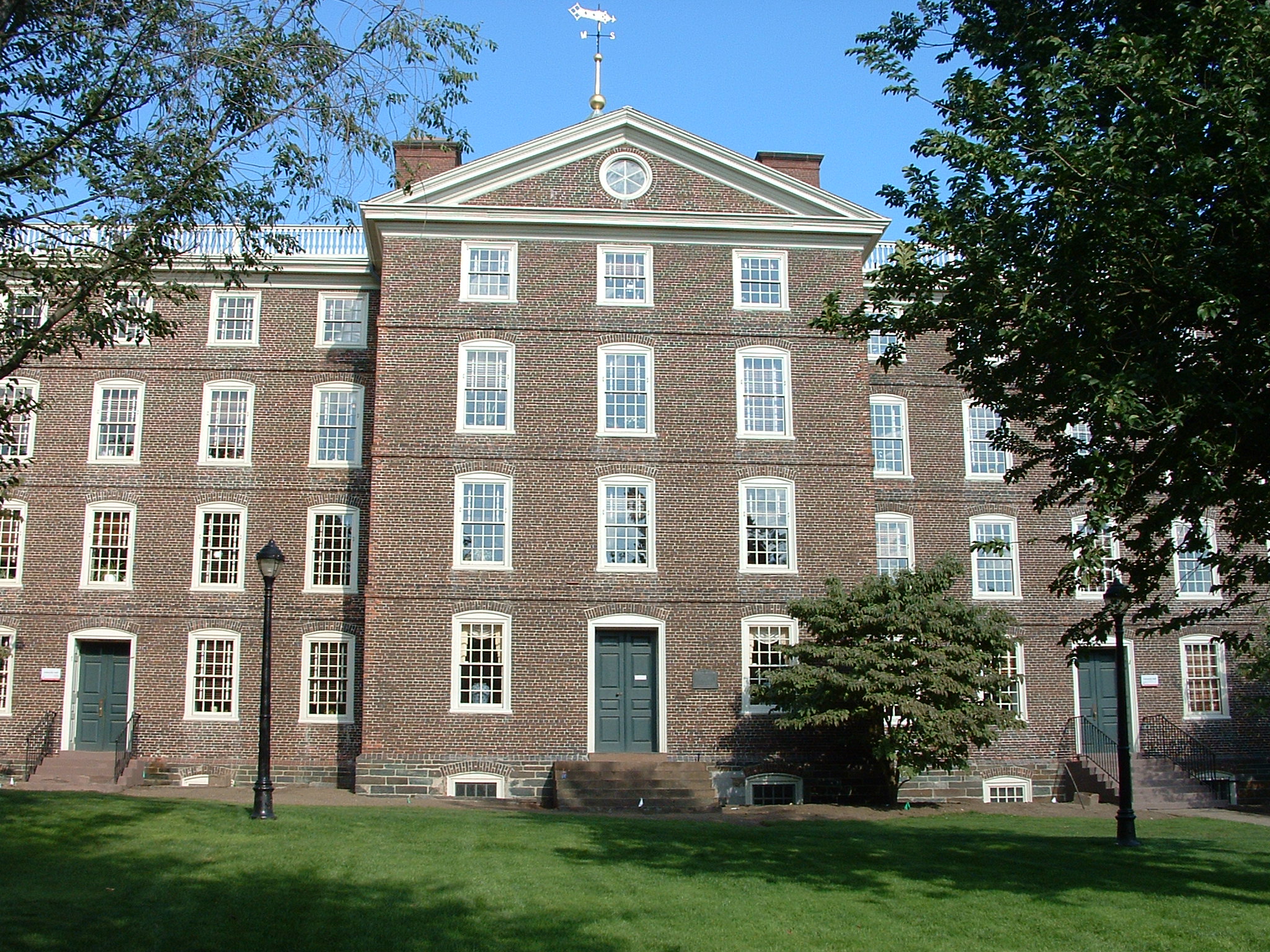
 Brown's University Hall, used as a hospital for injured troops.
The American and French troops took a combination of strategic roads and waterways from Philipsburg through New Jersey, Pennsylvania, Delaware, Maryland, the future District of Columbia, and Virginia, reaching Williamsburg in late September 1781.
With a French royal fleet blocking the Chesapeake, barring British reinforcements from New York or a sea escape for Cornwallis' army, Washington and Rochambeau's three-week siege of Yorktown ended in Cornwallis' surrender to Washington on October 19, 1781. After their victory, Washington and the Continentals returned to defend northern posts while Rochambeau and his troops wintered in Williamsburg prior to marching north the following summer. Both armies were warmly celebrated by the towns and cities along their return routes.
Rochambeau and the French Troops in Providence in 1780-81-82 Howard W. Preston. (Read before the Rhode Island Historical Society,March 12, 1922.)
They marched across Connecticut to join George Washington on the Hudson River at Dobbs Ferry, New York. The advance party was led by Armand Louis de Gontaut or Duc de Lauzun. Lauzun's Legion who marched ahead of the main army and stayed ten to fifteen miles (24 km) to the south protecting the exposed flank from the British [2].
The combined armies then marched through New Jersey, Pennsylvania, Delaware, and Maryland to Yorktown, Virginia. On September 22, they combined with the Marquis de Lafayette's troops and forced General Cornwallis to surrender on October 19 after the Siege of Yorktown and the Battle of the Chesapeake. After Yorktown, the French troops marched north again eventually ending in Boston, Massachusetts.
On Monday, March 30, 2009, U.S. President Barack Obama signed into law the Omnibus Public Land Management Act, one of whose provisions was to designate the Washington–Rochambeau Revolutionary Route as a National Historic Trail.
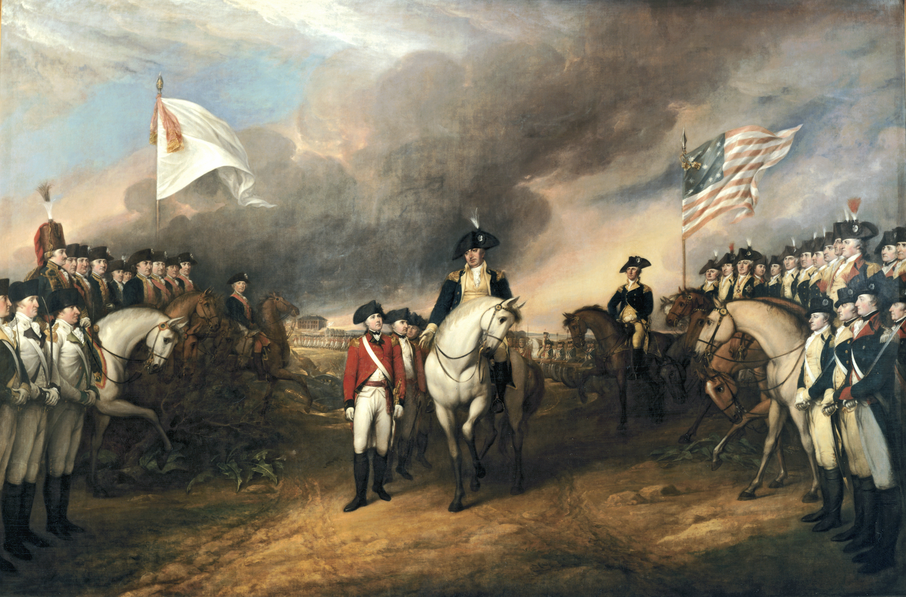
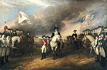 Surrender of Cornwallis at Yorktown by John Trumbull, depicting Cornwallis surrendering to the French troops of Rochambeau (left) and American troops of Washington (right). Oil on canvas, 1820.
March route of Rochambeau's army
Rhode Island to New York
 Landing of a French auxiliary army in Newport, Rhode Island on 11 July 1780, under the command of the comte de Rochambeau. This image is one of 12 scenes from the American Revolution printed in Allegemeines historisches Taschenbuch. The John Carter Brown Library at Brown University had acquired the book by 1870.
Rochambeau and his staff left the port of Newport, Rhode Island on June 10, 1781, arriving at Providence the following day. Over the next few days, the rest of the Rochambeau's army was transferred by boat to the first camp site in Providence. A grand review of the French Army took place at the Providence camp on June 16, 1781. The French Army began its march on June 18, proceeding in four divisions, with each division leaving one day apart. Each division had roughly the same amount of artillery and supplies, and each also had its own field hospital. Rochambeau himself left with the first division (the Bourbonnais Regiment) and arrived at the second camp site in Coventry in the evening of June 18 at a place known as Waterman's Tavern. The route between Providence and Coventry generally followed the alignment of Broadway in Providence to Olneyville, then Route 14 to the eastern side of the Scituate Reservoir. The original road is submerged in the reservoir but picks up again as Old Plainfield Pike in Scituate. West of Route 102 in Foster, the march route resumes following Route 14 into Coventry to the second camp.
From Coventry in Rhode Island, Rochambeau's army marched through Sterling, Connecticut via Route 14A (Plainfield Pike) to the third camp in Plainfield opposite Plainfield Cemetery, arriving on June 19. A 3.6-mile portion of the march route between the 2nd and 3rd camps has been listed on the National Register of Historic Places because "the road retains its narrow, hilly, winding character, and for most of its length, the characteristic borders of stone walls remain in place." The French found this particular segment to be difficult for marching, resulting in the late arrival of some artillery and supply wagons at the Plainfield camp. On June 20, Rochambeau's army continued their march along Route 14A to the town of Canterbury, then along Route 14, through Canterbury and Scotland into the town of Windham. While most of Route 14A and Route 14 have lost their 18th-century visual character, several short road segments remain preserved. Some of these road segments have been listed on the National Register of Historic Places. On such segment is in western Plainfield, Old Canterbury Road, which was bypassed by state highway construction in the 1930s, preserves some of the features of the original roadway, including the low stone walls lining the road. The designated portion of the route also includes a 1200-foot section of modern Route 14A east of the eastern end of Old Canterbury Road that maintains visual continuity of Old Canterbury Road. Another segment that was preserved as a result of being bypassed by the state highway is Manship Road and a portion of Barstow Road (between Manship Road and Route 14) in Canterbury, located midway between Canterbury Center and the village of Westminster. A segment of Route 14 east of Scotland Center has also been recognized as a preserved section of the march route. The designated segment runs from Miller Road to the top of a hill, about 800 feet east of Route 97. Known locally as Palmer Road, the low stone walls remain in place on both sides of this road segment and was described by the French as "a narrow, steep, and stony road". Yet another road segment between the 3rd and 4th camps is listed on the National Register, Scotland Road in Windham from Back Road to a point about 300 feet east of Ballahamack Road. This portion was one of the less difficult according to the French. While this road segment is mostly modern in appearance, the expansive views of the surrounding landscape, in addition to the preserved stone walls, contributes to the visual historical significance of the site. Rochambeau's army arrived in the evening of June 20 at the fourth camp in Windham by the Shetucket River, just west of Windham Center.
The French army continued its march through Connecticut, leaving the Windham camp on June 21. The army went past the village of Willimantic, roughly following modern Route 14 and Route 66. The French proceeded through Columbia and Andover towards the fifth camp site in Bolton. The march route proceeded along Route 66 then Route 6 until roughly the northwest corner of Andover. From there, the original road to Bolton Center, where the fifth camp of the French army was located, has been unused since the late 19th century and has been overgrown by forest. The following morning, on June 22, the French army continued its march from Bolton along Bolton Center Road (partly Route 85), continuing along Middle Turnpike East in Manchester until Route 6. From there the French followed Route 6 through Manchester Center to Silver Lane in East Hartford, where the sixth camp was located. The four divisions, which had been traveling a day apart, rested for three nights in East Hartford, necessitating additional camp sites in the same vicinity. Being a state highway trunkline route, the area surrounding Route 6 is heavily urbanized and has lost most of its historic character. However, in Andover and Bolton, two sections of the road that have been bypassed remain relatively preserved in their 18th century appearance. In Andover, the original march route (as well as the original Route 6) utilized what is now Hutchinson Road and Bailey Road. A segment of Hutchinson Road between Route 6 and Henderson Road retains the stone walls and mature trees along the side of the road, as well as the expansive views of open fields towards the Hop River. This road segment is listed on the National Register of Historic Places. The Daniel White Tavern, built in 1773 and used by French officers, still stands along this road segment. North of Henderson Road, Hutchinson Road has modern development and no longer has the visual continuity of the southern part of the road. Bailey Road originally connected Route 6 with Brandy Street in Bolton but the portion west of the Andover-Bolton town line has since been overgrown and is no longer passable by motor vehicles. A remnant of Bailey Road in Bolton (also listed on the National Register of Historic Places) still exists as an unpaved foot path and still retains the characteristic stone walls as well as two original stone culverts.
The first division of Rochambeau's army crossed the Connecticut River by ferry on June 25 into Hartford, with the other divisions following in one day intervals as before. From there, they traveled along Farmington Avenue through West Hartford until Farmington, the site of the seventh camp. The camp site was located toward the south end of the town center village. Rochambeau and his officers are said to have stayed at the Elm Tree Inn. After staying overnight in Farmington Center, on June 26, the French army followed Route 10 through the town center of Southington until the Milldale section of town, then headed west along Route 322 until they reached the eighth camp site in the Marion section of Southington. Rochambeau and his officers stayed at the Asa Barnes Tavern. The following day, the French continued westward along Route 322, then Meriden Road into Waterbury. In Waterbury, the route followed East Main Street and West Main Street, crossing the Naugatuck River along the way. The road west of Waterbury was difficult and characterized by the French as being "détestables" for being very stony and mountainous. The route continued into present-day Middlebury, specifically the area around Breakneck Hill. The march route followed Park Road to Watertown Road, then turned south on Watertown Road until Breakneck Hill Road. The ninth camp was located at the foot of Breakneck Hill, where the first division stayed the night of June 27. Rochambeau and his officers were entertained at the Israel Bronson Tavern.
On June 28, the first division resumed its march heading south on Artillery Road and Middlebury Road (Route 64) through the town center of Middlebury, then continuing along Route 188 and Waterbury Road into the center of Southbury. The French army continued west along Main Street South and River Road through Southbury, crossing the Housatonic River into the town of Newtown using a bridge built in by the Colonial troops in 1778 at Glen Road. The French army continued along Church Hill Road through the center of Newtown where they setup their tenth camp west of the town center. The officers stayed in Caleb Baldwin's Tavern. Rochambeau reorganized his troops into two brigades in Newtown. The first division resumed its march on June 30 heading west on West Street and Castle Hill Road, then turning north along Reservoir Road and west again on Route 6. The Reservoir Road portion is well-preserved and is listed on the National Register of Historic Places. The French army marched along Route 6 and Newtown Road into Danbury. In Danbury, the French troops utilized West Worcester Street, Park Avenue and Backus Avenue to reach the Ridgebury section of the town of Ridgefield. The eleventh camp was setup on July 1 in Ridgebury near the Congregational Church.
The French army resumed its march on the morning of July 2 through the town of Ridgefield, heading south on Ridgebury Road then turning west on Mopus Bridge Road. After crossing the New York state line, the French continued southwest and south following Route 121 past the hamlets of North Salem and Cross River until the hamlet of Bedford Village. The first brigade setup camp in Bedford Village (12th camp) and resumed the following day while the second brigade skipped the Bedford camp. The French continued west along Route 172 to what is now the village of Mount Kisco, about five miles away west of the Bedford camp. The French stayed in Mount Kisco for several days until the morning of July 6. They marched west and south for 16 miles along Route 133 and Route 100 to the Hartsdale area of the town of Greenburgh. The French camped in several locations in Greenburgh (14th camp) for the next six weeks.
New York to Pennsylvania
Historic preservation
 Joseph Webb House in 2009
A series of sites along the route have been listed on the U.S. National Register of Historic Places or otherwise recognized and preserved. Buildings or roadway or other artifacts at these sites have been preserved and still evoke the army's passage in 1781 and/or its return in 1782. A multiple property documentation study completed in 2001 addressed many of the Connecticut sites, and outlined criteria for NRHP-eligibility of others.[3] Recognized historic sites include:[4]
in New Jersey
- The Fell House, Allendale, New Jersey
in Rhode Island
- University Hall, Providence, Rhode Island
- Waterman's Tavern, Coventry, Rhode Island
in Windham County, Connecticut
- Dorrance Inn, Sterling, Connecticut
- Fourth Camp of Rochambeau's Army, Windham, Connecticut
- Forty-Seventh Camp of Rochambeau's Army, Windham, Connecticut
- March Route of Rochambeau's Army: Scotland Road, Windham, Connecticut
- March Route of Rochambeau's Army: Palmer Road, Scotland, Connecticut
- March Route of Rochambeau's Army: Manship Road-Barstow Road, Canterbury, Connecticut
- March Route of Rochambeau's Army: Old Canterbury Road, Plainfield, Connecticut
- March Route of Rochambeau's Army: Plainfield Pike, Plainfield, Connecticut
in New London County, Connecticut
- John Trumbull Birthplace, Lebanon, Connecticut
- Governor Jonathan Trumbull's War Office in Lebanon, Connecticut, also known as the Joseph Trumble Office and Store, which was the most important Revolutionary War-associated building in Connecticut
- William Williams House, in Lebanon, Connecticut, a U.S. National Historic Landmark
in Tolland County, Connecticut
- Daniel White Tavern, Andover, Connecticut
- March Route Rochambeau's Army--Hutchinson Road, Andover, Connecticut
- Fifth Camp of Rochambeau's Infantry, Bolton, Connecticut
- March Route of Rochambeau's Army: Bailey Road, Bolton, Connecticut
in Hartford County, Connecticut
- Joseph Webb House, Wethersfield, Connecticut
- Marion Historic District, Southington, Connecticut
- Levi B. Frost House also known as Asa Barnes Tavern in the 1780s, in Southington, Connecticut
 Asa Barnes Tavern/Levi B. Frost House in Southington, Connecticut] in 2011
in New Haven County, Connecticut
- Josiah Bronson House, Middlebury, Connecticut
in Fairfield County, Connecticut
- Caleb Baldwin Tavern, in Newtown, Connecticut
- Newtown Borough Historic District, Newtown, Connecticut
- March Route of Rochambeau's Army: Reservoir Road, a segment of roadway in Newtown, Connecticut
- Camps Nos. 10 and 41 of Rochambeau's Army, Newtown, Connecticut
- March Route of Rochambeau's Army: Ridgebury Road, Ridgefield, Connecticut
- Monroe Center Historic District, whose Monroe Center Green was site of a dance for 600 of Rochambeau's troops on June 30, 1781
- Daniel Basset House, in Monroe, Connecticut, built in 1775, site of a ball was held for the French officers of Lauzun's mounted section of Rochambeau's army on June 30, 1781, which camped nearby.[5]
See also
- British colonization of the Americas
- Colonial America
- Colonial American military history
- Colonial history of the United States
- Historic regions of the United States
- Society of the Cincinnati
- Brown University
- Providence, Rhode Island
- James Manning
- James Mitchell Varnum
- Nathanael Greene
- Armand Louis de Gontaut
- King's Highway (Charleston to Boston)
- Lauzun's Legion
- Newtown, Connecticut
- Sons of the American Revolution
- History of Trumbull, Connecticut
- Jean Baptiste, marquis de Traversay
- Maxime Julien Émeriau de Beauverger
- Louis-René Levassor de Latouche Tréville
- Gilbert du Motier
- Louis Marc Antoine de Noailles
- Georges René Le Peley de Pléville
- Charles Armand Tuffin
- Jean Gaspard Vence
- Alexandre-Théodore-Victor
- Pierre Beaumarchais
- Charles Gravier
- King Louis XVI of France
- François-Joseph Paul
- Jean-Frédéric Phélypeaux
Notes
- ^ Rhode Island Historical Society Collections, XVII, No. 1 (January 1924).
- ^ Life and Letters of Samuel Holden Parsons, Major General in the Continental Army and Chief Judge of the Northwestern Territory 1737 — 1789, Charles S. Hall 1905, page 364 [1]
- ^ Bruce Clouette and Mary Harper (October 22, 2001). "National Register of Historic Places Multiple Property Documentation: Rochambeau's Army in Connecticut, 1780-1782 MPS". National Park Service. http://pdfhost.focus.nps.gov/docs/NRHP/Text/64500789.pdf.
- ^ "National Register Information System". National Register of Historic Places. National Park Service. 2009-03-13. http://nrhp.focus.nps.gov/natreg/docs/All_Data.html.
- ^ Bruce Clouette (February 1, 2001). "National Register of Historic Places Registration: Daniel Basset House". National Park Service. http://pdfhost.focus.nps.gov/docs/NRHP/Text/02000870.pdf. and Accompanying four photos, exterior, from 2001 (see captions p. 9 of text document)
References
- Charles S. Hall, Life and Letters of Samuel Holden Parsons, Ostenigo Publishing Co., Binghamton, NY, 1905
External Sources
French Armed Forces 
Components French Air Force French Army French Navy Gendarmerie Ranks Ranks in the French Army Ranks in the French Navy History of the French Military Military History of France La Grande Armée - National Friends & Society of the Washington Rochambeau Revolutionary Route National HT
- Official site
- "The Washington-Rochambeau Revolutionary Route, America's Route to Destiny", Dr. James M. Johnson, Yorktown History
- France and the American Revolution at the John Carter Brown Library
- "Washington–Rochambeau Revolutionary Route Study", NPS
- "The Washington-Rochambeau Route Markers", HMdB
- "Background on the Washington-Rochambeau Revolutionary Route in Virginia", Expédition Particulière, 4 June 2009
- Washington, DC National Trails
- Encyclopedia Brunoniana - University Hall
- Rhode Island Historical Society
- Society of the Cincinnati - library
- French Naval Leaders and the French Navy in the American War for Independence
- Degrees of Latitude: Mapping Colonial America by Margaret Pritchard
- The Long March to Yorktown by Donald N. Moran
National Trails System National Scenic Trails National Historic Trails Ala Kahakai Trail • California Trail • Captain John Smith Chesapeake Trail • El Camino Real de los Tejas Trail • El Camino Real de Tierra Adentro • Iditarod Trail • Juan Bautista de Anza Trail • Lewis and Clark Trail • Mormon Trail • Nez Perce Trail • Old Spanish Trail • Oregon Trail • Overmountain Victory Trail • Pony Express Trail • Santa Fe Trail • Selma to Montgomery Trail • Star-Spangled Banner Trail • Trail of Tears • Washington–Rochambeau Revolutionary Route
National Recreation Trails National Geologic Trail Ice Age Floods Trail
Major armed conflicts involving the United States Armed Forces listed chronologicallyInternal Shays' Rebellion · Whiskey Rebellion · Dorr Rebellion · Mormon War · Bleeding Kansas · Utah War · Civil War · Indian Wars · Brooks–Baxter War · Coal Creek War · Homestead Strike · Battle of Blair Mountain · Bonus Army
International Revolutionary War · Quasi-War · First Barbary War · War of 1812 · Second Barbary War · First Sumatran Expedition · Second Sumatran Expedition · Ivory Coast Expedition · Mexican–American War · First Fiji Expedition · Second Opium War · Second Fiji Expedition · Korean Expedition · Spanish–American War · Philippine–American War · Boxer Rebellion · Banana Wars · Border War · World War I · Russian Civil War · World War II · Korean War · Vietnam War · Invasion of the Dominican Republic · Invasion of Grenada · Lebanese Civil War · Invasion of Panama · Gulf War · Somali Civil War · Bosnian War · Kosovo War · Afghanistan War · Iraq War · War in North-West Pakistan · Libyan Civil War · Lord's Resistance Army insurgency
Related articles List of conflicts in the U.S. · List of wars involving the U.S. · Timeline of U.S. military operations · Length of U.S. participation in major wars · Overseas expansion · Military history · Covert regime-change actions · Casualties of war
Units By StateConnecticut • Delaware • Georgia • Maryland • Massachusetts • New Hampshire • New Jersey • New York • North Carolina • Pennsylvania • Rhode Island • South Carolina • VirginiaBy Year1775 • 1776 • 1777–1784OtherAdditional Regiments • Extra Regiments • Canadian Regiments (1st • 2nd) • Militia units that participated alongsideEvents  Foreign Ministers of France
Ancien régime Revol · Villeroy · A. J. Richelieu · Sillery · R. Phélypeaux · Bouthillier · Chavigny · Brienne · Lionne · Pomponne · Croissy · Torcy · Huxelles · Dubois · Morville · Chauvelin · Chaillou · Noailles · Argenson · Puisieulx · Saint-Contest · Rouillé · Bernis · E. Choiseul · C. Choiseul · E. Choiseul · L. Phélypeaux · Aiguillon · Bertin · Vergennes · Montmorin · Vauguyon · Montmorin · Lessart · Dumouriez · Naillac · Chambonas · Dubouchage · Sainte-Croix · LebrunFirst Republic First Empire Restoration Laforest · TalleyrandHundred Days Restoration Talleyrand · A. E. Richelieu · Dessolles · Pasquier · M. Montmorency · Chateaubriand · Damas · Ferronays · A. Montmorency · Portalis · Polignac · MortemartJuly Monarchy Second Republic Second Empire Interregnum Third Republic Rémusat · A. Broglie · Decazes · Banneville · Waddington · Freycinet · Duclerc · Fallières · Challemel-Lacour · Ferry · Freycinet · Flourens · Goblet · Spuller · Ribot · Develle · Casimir-Perier · Hanotaux · Berthelot · Bourgeois · Pichon · Cruppi · Selves · Poincaré · Jonnart · Pichon · Doumergue · Bourgeois · Viviani · Doumergue · Delcassé · Viviani · Briand · Ribot · Barthou · Pichon · Millerand · Leygues · Briand · Poincaré · Lefebvre · Herriot · Briand · Herriot · Briand · Laval · Tardieu · Herriot · Paul-Boncour · Daladier · Barthou · Laval · Flandin · Delbos · Paul-Boncour · Bonnet · Daladier · Reynaud · Daladier · ReynaudVichy France Provisional
GovernmentFourth Republic Fifth Republic Couve de Murville · Debré · Schumann · Bettencourt · Jobert · Sauvagnargues · Guiringaud · François-Poncet · Cheysson · Dumas · Raimond · Dumas · Juppé · Charette · Védrine · Villepin · Barnier · Douste-Blazy · Kouchner · Alliot-Marie · JuppéChief Ministers to the French Monarch Cardinal Richelieu · Cardinal Mazarin · Cardinal Dubois · HRH the Duke of Orléans · HSH the Duke of Bourbon · Cardinal de Fleury · Duke of Choiseul · Duke of Aiguillon · Count of Maurepas · Count of Vergennes · Monsieur de Loménie de Brienne · Monsieur Necker · Monsieur Le Tonnelier de Breteuil · Count of Montmorin
British Empire and Commonwealth of Nations Legend
Current territory · Former territory
* now a Commonwealth realm · now a member of the Commonwealth of NationsEurope18th century
1708–1757 Minorca
since 1713 Gibraltar
1763–1782 Minorca
1798–1802 Minorca19th century
1800–1964 Malta
1807–1890 Heligoland
1809–1864 Ionian Islands20th century
1921-1937 Irish Free StateNorth America17th century
1583–1907 Newfoundland
1607–1776 Virginia
since 1619 Bermuda
1620–1691 Plymouth Colony
1629–1691 Massachusetts Bay Colony
1632–1776 Maryland
1636–1776 Connecticut
1636–1776 Rhode Island
1637–1662 New Haven Colony
1663–1712 Carolina
1664–1776 New York
1665–1674 and 1702-1776 New Jersey
1670–1870 Rupert's Land
1674–1702 East Jersey
1674–1702 West Jersey
1680–1776 New Hampshire
1681–1776 Pennsylvania
1686–1689 Dominion of New England
1691–1776 Massachusetts18th century
1701–1776 Delaware
1712–1776 North Carolina
1712–1776 South Carolina
1713–1867 Nova Scotia
1733–1776 Georgia
1763–1873 Prince Edward Island
1763–1791 Quebec
1763–1783 East Florida
1763–1783 West Florida
1784–1867 New Brunswick
1791–1841 Lower Canada
1791–1841 Upper Canada19th century
1818–1846 Columbia District / Oregon Country1
1841–1867 Province of Canada
1849–1866 Vancouver Island
1853–1863 Colony of the Queen Charlotte Islands
1858–1866 British Columbia
1859–1870 North-Western Territory
1862–1863 Stikine Territory
1866–1871 Vancouver Island and British Columbia
1867–1931 *Dominion of Canada2
20th century
1907–1949 Dominion of Newfoundland31Occupied jointly with the United States
2In 1931, Canada and other British dominions obtained self-government through the Statute of Westminster. see Canada's name.
3Gave up self-rule in 1934, but remained a de jure Dominion until it joined Canada in 1949.Latin America and the Caribbean17th century
1605–1979 *Saint Lucia
1623–1883 Saint Kitts (*Saint Kitts & Nevis)
1624–1966 *Barbados
1625–1650 Saint Croix
1627–1979 *St. Vincent and the Grenadines
1628–1883 Nevis (*Saint Kitts & Nevis)
1629–1641 St. Andrew and Providence Islands4
since 1632 Montserrat
1632–1860 Antigua (*Antigua & Barbuda)
1643–1860 Bay Islands
since 1650 Anguilla
1651–1667 Willoughbyland (Suriname)
1655–1850 Mosquito Coast (protectorate)
1655–1962 *Jamaica
since 1666 British Virgin Islands
since 1670 Cayman Islands
1670–1973 *Bahamas
1670–1688 St. Andrew and Providence Islands4
1671–1816 Leeward Islands
18th century
1762–1974 *Grenada
1763–1978 Dominica
since 1799 Turks and Caicos Islands19th century
1831–1966 British Guiana (Guyana)
1833–1960 Windward Islands
1833–1960 Leeward Islands
1860–1981 *Antigua and Barbuda
1871–1964 British Honduras (*Belize)
1882–1983 *Saint Kitts.2C 1623 to 1700|St. Kitts and Nevis
1889–1962 Trinidad and Tobago
20th century
1958–1962 West Indies Federation4Now the San Andrés y Providencia Department of Colombia
Africa18th century
1792–1961 Sierra Leone
1795–1803 Cape Colony19th century
1806–1910 Cape Colony
1810–1968 Mauritius
1816–1965 Gambia
1856–1910 Natal
1868–1966 Basutoland (Lesotho)
1874–1957 Gold Coast (Ghana)
1882–1922 Egypt
1884–1966 Bechuanaland (Botswana)
1884–1960 British Somaliland
1887–1897 Zululand
1888–1894 Matabeleland
1890–1965 Southern Rhodesia (Zimbabwe) 5
1890–1962 Uganda
1890–1963 Zanzibar (Tanzania)
1891–1964 Nyasaland (Malawi)
1891–1907 British Central Africa Protectorate
1893–1968 Swaziland
1895–1920 East Africa Protectorate
1899–1956 Anglo-Egyptian Sudan20th century
1900–1914 Northern Nigeria
1900–1914 Southern Nigeria
1900–1910 Orange River Colony
1900–1910 Transvaal Colony
1906–1954 Nigeria Colony
1910–1931 South Africa
1911–1964 Northern Rhodesia (Zambia)
1914–1954 Nigeria Colony and Protectorate
1915–1931 South West Africa (Namibia)
1919–1960 Cameroons (Cameroon) 6
1920–1963 Kenya
1922–1961 Tanganyika (Tanzania) 6
1954–1960 Nigeria
1979–1980 Southern Rhodesia (Zimbabwe) 55Southern Rhodesia issued a Unilateral Declaration of Independence in 1965 (as Rhodesia) and returned to British control in 1979.
6League of Nations mandateAsia18th century
1702–1705 Côn Đảo
1757–1947 Bengal (West Bengal (India) and Bangladesh)
1762–1764 Manila
1795–1948 Ceylon (Sri Lanka)
1796–1965 Maldives19th century
1812-1824 Banka (Sumatra)
1812-1824 Billiton (Sumatra)
1819–1826 British Malaya (Peninsular Malaysia and Singapore)
1826–1946 Straits Settlements
1839–1967 Colony of Aden
1839–1842 Afghanistan
1841–1997 Hong Kong
1841–1941 Kingdom of Sarawak (Malaysia)
1858–1947 British India (India, Pakistan and Bangladesh, Burma)
1879–1919 Afghanistan
1882–1963 British North Borneo (Malaysia)
1885–1946 Unfederated Malay States
1888–1984 Sultanate of Brunei
1888–1946 Sultanate of Sulu
1891–1971 Muscat and Oman protectorate
1892–1971 Trucial States protectorate
1895–1946 Federated Malay States
1898–1930 Weihai Garrison
1878–1960 Cyprus20th century
1918–1961 Kuwait protectorate
1920–1932 Iraq6
1921–1946 Transjordan6
1923–1948 Palestine6
1945–1946 South Vietnam
1946–1963 Sarawak (Malaysia)
1946–1963 Singapore
1946–1948 Malayan Union
1948–1957 Federation of Malaya (Malaysia)
since 1960 Akrotiri and Dhekelia (before as part of Cyprus)
since 1965 British Indian Ocean Territory (before as part of Mauritius and the Seychelles)Oceania18th century
1788–1901 New South Wales19th century
1803–1901 Van Diemen's Land/Tasmania
1807–1863 Auckland Islands7
1824–1980 New Hebrides (Vanuatu)
1824–1901 Queensland
1829–1901 Swan River Colony/Western Australia
1836–1901 South Australia
since 1838 Pitcairn Islands
1841–1907 Colony of New Zealand
1851–1901 Victoria
1874–1970 Fiji8
1877–1976 British Western Pacific Territories
1884–1949 Territory of Papua
1888–1965 Cook Islands7
1889–1948 Union Islands (Tokelau)7
1892–1979 Gilbert and Ellice Islands9
1893–1978 British Solomon Islands1020th century
1900–1970 Tonga (protected state)
1900–1974 Niue7
1901–1942 *Commonwealth of Australia
1907–1953 *Dominion of New Zealand
1919–1942 Nauru
1945–1968 Nauru
1919–1949 Territory of New Guinea
1949–1975 Territory of Papua and New Guinea117Now part of the *Realm of New Zealand
8Suspended member
9Now Kiribati and *Tuvalu
10Now the *Solomon Islands
11Now *Papua New GuineaAntarctica and South Atlantic17th century
since 1659 St. Helena1219th century
since 1815 Ascension Island12
since 1816 Tristan da Cunha12
since 1833 Falkland Islands1320th century
since 1908 British Antarctic Territory14
since 1908 South Georgia and the South Sandwich Islands13, 1412Since 2009 part of Saint Helena, Ascension and Tristan da Cunha; Ascension Island (1922—) and Tristan da Cunha (1938—) were previously dependencies of St Helena
13Occupied by Argentina during the Falklands War of April–June 1982
14Both claimed in 1908; territories formed in 1962 (British Antarctic Territory) and 1985 (South Georgia and the South Sandwich Islands)Categories:- National Historic Trails of the United States
- American Revolutionary War
- 1781 in the United States
- 1781 in France
- Rhode Island in the American Revolution
- Connecticut in the American Revolution
- New York in the American Revolution
- Delaware in the American Revolution
- Pennsylvania in the American Revolution
- New Jersey in the American Revolution
- Maryland in the American Revolution
- Virginia in the American Revolution
- North Carolina in the American Revolution
- Campaigns of the American Revolutionary War
- York County, Virginia
- Newport, Rhode Island


Wikimedia Foundation. 2010.