- Mamble
-
Coordinates: 52°20′27″N 2°27′24″W / 52.3407°N 2.4566°W
Mamble 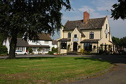
Sun and Slipper, Mamble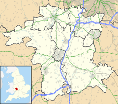
 Mamble
Mamble shown within WorcestershireOS grid reference SO689714 Parish Mamble District Malvern Hills Shire county Worcestershire Region West Midlands Country England Sovereign state United Kingdom Post town KIDDERMINSTER Postcode district DY14 Police West Mercia Fire Hereford and Worcester Ambulance West Midlands EU Parliament West Midlands UK Parliament West Worcestershire List of places: UK • England • Worcestershire Mamble is a village and civil parish in the Malvern Hills District in the county of Worcestershire, England. It is located on the A456 between Bewdley and Cleobury Mortimer. Notable buildings include the 13th century sandstone church of St John the Baptist and the 17th century Sun & Slipper Inn[citation needed]. A craft centre that existed previously was closed in summer 2006.
Roman remains have been found in the area, and at the time of the Domesday Book the settlement was known as Mamele. Although agriculture was always a major industry for the inhabitants of Mamble, coal mining was also important from the 14th century onwards, and the last local pit, at Hunthouse to the south-east of the village, remained in operation until its closure in 1972. In the 1790s the Leominster Canal was opened in the area which allowed coal to be carried to Tenbury Wells and Herefordshire, but the canal was unprofitable and was closed in 1859.[citation needed]
The poet John Drinkwater wrote a poem about the village, called simply Mamble:[1]
“ I NEVER went to Mamble
That lies above the Teme,
So I wonder who's in Mamble,
, And whether people seem
Who breed and brew along there
As lazy as the name,
And whether any song there
Sets alehouse wits aflame.
The finger-post says Mamble,
And that is all I know
Of the narrow road to Mamble,
And should I turn and go
To that place of lazy token
That lies above the Teme,
There might be a Mamble broken
That was lissom in a dream.
So leave the road to Mamble
And take another road
To as good a place as Mamble
Be it lazy as a toad ;
Who travels Worcester county
Takes any place that comes
When April tosses bounty
To the cherries and the plums.” References
- ^ Drinkwater, John, Selected Poems of John Drinkwater, pp.31-32. 'Mamble' (From Swords and Ploughshares, 1915) published 1922 Sidgwick & Jackson, Ltd. London. Retrieved 21 June 2009
Categories:- Villages in Worcestershire
- Worcestershire geography stubs


Wikimedia Foundation. 2010.